Scientists have made the first-ever remote observations of the fine-scale structure at the base of clouds. The results show that the air-cloud interface is a transition zone where aerosol particles suspended in Earth’s atmosphere give rise to the droplets that ultimately form clouds.
Tag: Remote Sensing
Seize the opportunity: satellite images enabled to estimate the salinity of the Azov Sea
Russian hydrophysicists elaborated a method for research of salinity of the Azon Sea with the help of data from the remote sensing. Scientists matched satellite images of water surface with field measurements and discovered that they can prognose salinity of water with an accuracy to 95%.
UAH researchers closing in on helping to solve 60-year-old solar mystery
Researchers at The University of Alabama in Huntsville (UAH), a part of the University of Alabama System, have supported a ground-breaking measurement that is helping solve a 60-year-old cosmic mystery that involves the question of why the Sun’s corona, the outermost part of the Sun’s atmosphere, is so much hotter than the surface of the Sun itself.
Urban climate research project helps shape minority students’ science identity
An Urban Integrated Field Laboratory led by Argonne is focusing on creating a diverse next generation workforce and involving students in tackling future urban climate challenges.
New algorithm maps safest routes for city drivers
A group developed a new approach which identifies the safest possible route in an urban network using real-time crash risk data, and can be incorporated into navigation apps such as Google Maps.
FAU Developed AUTOHOLO Shows Potential as Red Tide Warning System
Current methods to monitor red tide are limited. Using AUTOHOLO, a new autonomous, submersible, 3D holographic microscope and imaging system, a study is the first to characterize red tide in the field and breaks new ground for monitoring harmful algal blooms.
From ground to air to space: Tillage estimates get tech boost
In a new study, University of Illinois scientists demonstrate a way to accurately map tilled land in real time by integrating ground, airborne, and satellite imagery.
Eavesdropping on the Earth itself
The more-than 1.2 million km of fibre-optic cables that criss-cross the planet carry the world’s phone calls, internet signals and data.
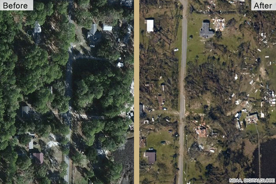
Remote sensing research improves hurricane response
Researchers with the FAMU-FSU College of Engineering’s Resilient Infrastructure and Disaster Response (RIDER) Center are investigating better ways to predict where road-clogging debris will be most severe after tropical cyclones.
Keeping Time With The Cosmos
Various technologies, networks and institutions benefit from or require accurate time keeping to synchronize their activities. Current ways of synchronizing time have some drawbacks that a new proposed method seeks to address.
Eureka! A cost effective and quick way to find groundwater in arid regions
Water is a scarce commodity in many countries worldwide, but new cost effective technology pioneered by researchers in Australia, Egypt and Saudi Arabia could ensure sustainable water supplies for decades to come.
Drone helps researchers find fresh water in the sea at Easter Island
Researchers at Binghamton University, State University of New York have demonstrated the effectiveness of using drones to locate freshwater sources at Easter Island.
Will this be the face of 7G?
Moving from the GHz regime into the THz regime…
Field biologists and NASA planes to map biodiversity in South Africa’s Greater Cape Floristic Region
Scientists from the U.S. and South Africa are launching a campaign to map marine, freshwater, and terrestrial species and ecosystems in one of Earth’s biodiversity hotspots: the Greater Cape Floristic Region at the southwestern edge of South Africa.
FAU Lands $736,000 from NASA to Study the Coastal Carbon Budget from Space
If successful, this research in the Gulf of Mexico’s hypoxia region off the coasts of Texas and Louisiana may demonstrate not just the ability, but also the utility, of remote sensing as an observational technique for characterizing potentially critical but often neglected carbon cycle processes related to marine sediments. Researchers will use satellite images, hydrodynamic modeling and field work in seeking a better understanding of the ocean’s role in the Earth system.
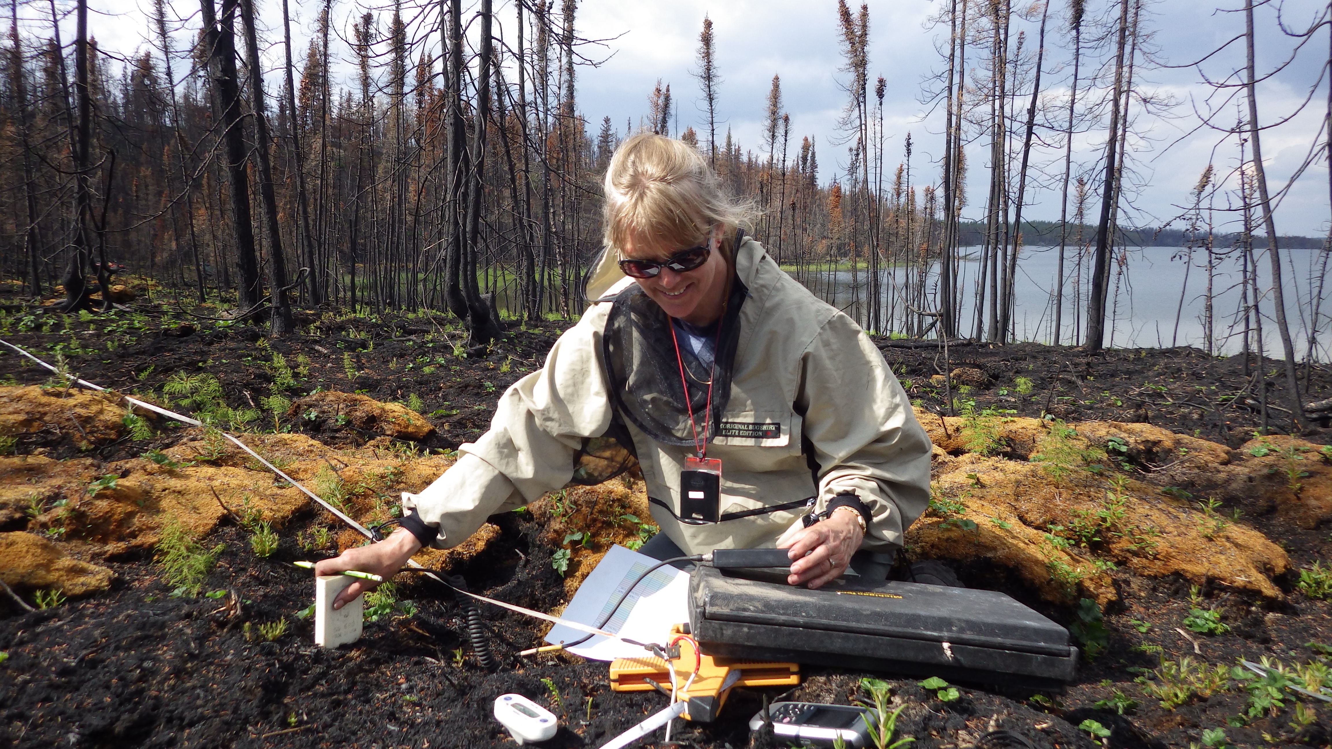
Russian forests are crucial to global climate mitigation
A new study by IIASA researchers, Russian experts, and other international colleagues have produced new estimates of biomass contained in Russian forests, confirming a substantial increase over the last few decades.
Driving in the Snow is a Team Effort for AI Sensors
Nobody likes driving in a blizzard, including autonomous vehicles. To make self-driving cars safer on snowy roads, Michigan Tech engineers look at the problem from the car’s point of view–its sensors.
Using satellite images to protect national security
The South Dakota State University Image Processing Laboratory is helping intelligence agencies use remote-sensing satellite images to protect national security.
The Jackson Pollock of THz Photomixing
Electronics so pretty they could hang on your wall.
Explosive Origins of ‘Secondary’ Ice—and Snow
Where does snow come from? This may seem like a simple question to ponder as half the planet emerges from a season of watching whimsical flakes fall from the sky–and shoveling them from driveways. But a new study on how water becomes ice in slightly supercooled Arctic clouds may make you rethink the simplicity of the fluffy stuff. It describes definitive, real-world evidence for “freezing fragmentation” of drizzle as a major source of ice in slightly supercooled clouds. The findings have important implications for forecasting weather and climate.
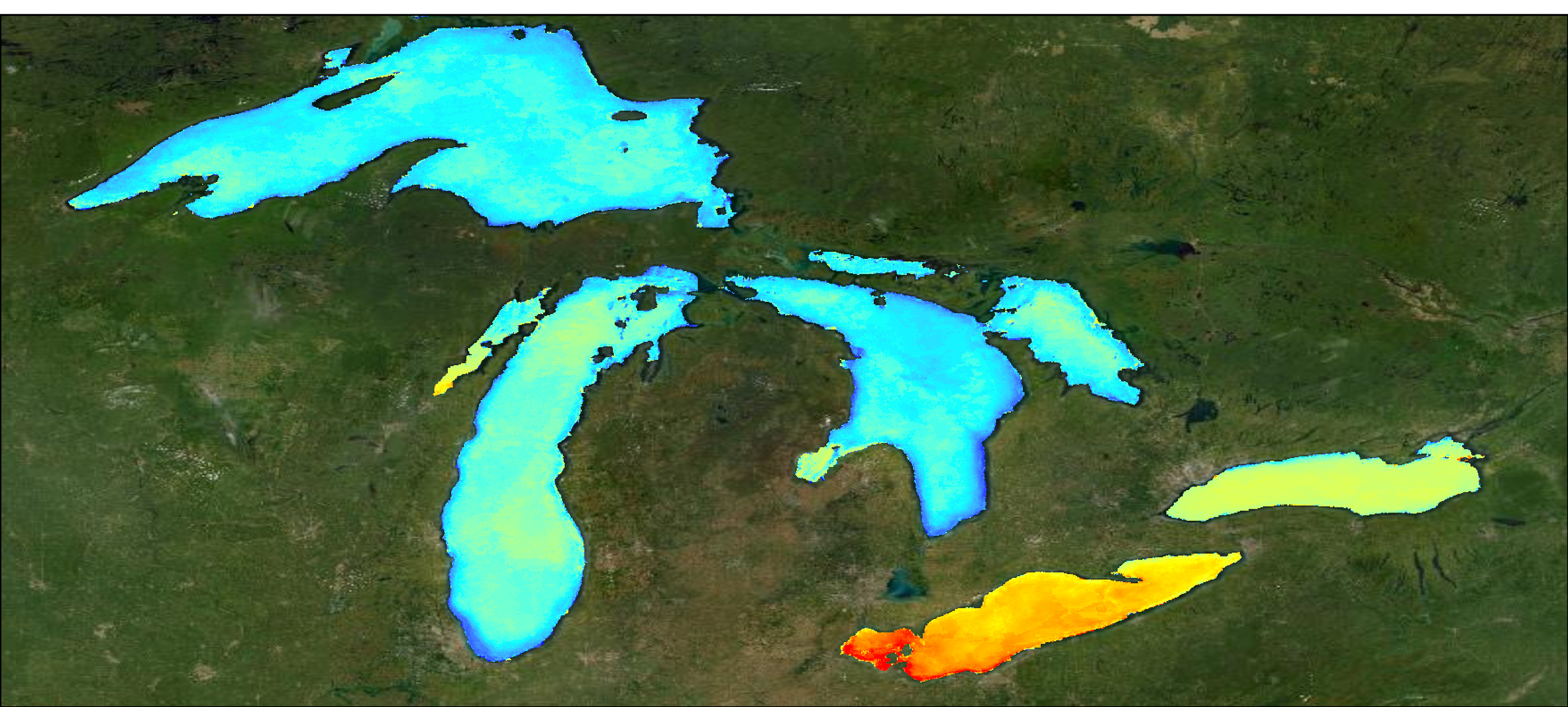
World’s Largest Lakes Reveal Climate Change Trends
Sixteen years of remote sensing data reveals that in Earth’s largest freshwater lakes, climate change influences carbon fixation trends.

Remote Sensing Expert: World’s Largest Lakes Reveal Climate Change Trends
Mike Sayers, Michigan Tech Research Institute research scientist, is available to speak to using remote sensing to discover how climate change affects the world’s largest freshwater lakes, which account for 50% of the Earth’s surface freshwater. Sayers’ NASA-funded research shows how…
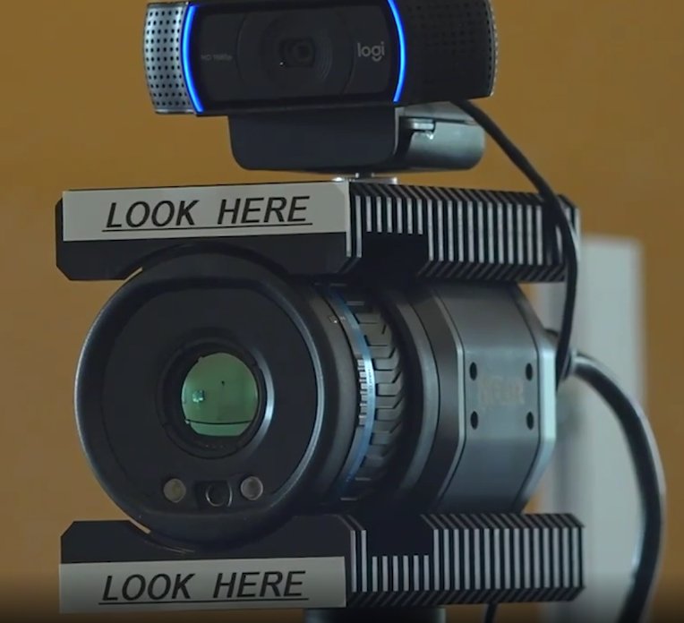
Think you have COVID? This camera could tell you
A key symptom of COVID-19 – oxygen saturation – is now being estimated remotely from a camera, thanks to research from University of South Australia engineers Professor Javaan Chahl, Dr Ali Al-Naji and their team of graduate students.
Michigan Tech remote sensing, ecology experts available to speak to wildfire carbon emissions, climate-related ecosystem changes
Michigan Technological University has remote sensing and ecology experts available to speak to wildfire carbon emissions, climate-related ecosystem changes, and the effects of wildfires on peatlands — which act as huge carbon sinks and when burned release an incredible amount…
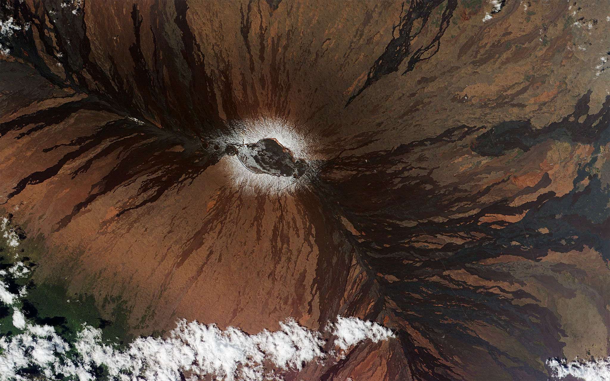
Deep learning artificial intelligence keeps an eye on volcano movements
Penn State researchers have used artificial intelligence (AI) to clear up that noise, drastically facilitating and improving near real-time observation of volcanic movements and the detection of volcanic activity and unrest.
UCLA Fielding School of Public Health joins consortium to address environmental change and its health impacts
The UCLA Fielding School of Public Health (FSPH) has joined the Planetary Health Alliance (PHA), a consortium of more than 200 universities, research institutes, and government agencies committed to understanding and addressing global environmental change and its health impacts.
How do wildfires affect ecosystems, the atmosphere, & human health? Connecting wildfire fuel to how fires behave & what ends up in the smoke.
What are the effects of wildfires on the ecosystem, the atmosphere, and human health? Through remote sensing, Nancy French, senior research scientist at the Michigan Tech Research Institute, connects wildfire fuel to how fires behave and what ends up in…
THz Spectrometers: ‘Ford vs. Ferrari’
Bakman continues to expand the market for THz technology – focusing on economical, reliable, rugged, application-specific THz sensors.
Scientists look to space to track plant pathogens coasting through atmosphere
To better understand how plant pathogens that travel the globe with dust particles might put crops at risk, a Cornell University-led team of scientists will use data from NASA’s Earth Observing Satellites to identify areas of potential disease and track plumes of dust that traverse the globe.
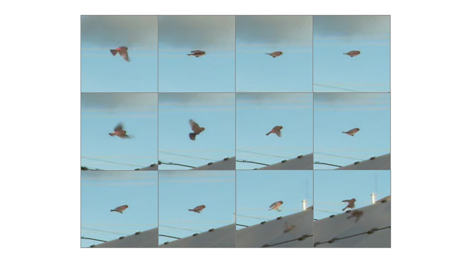
Deep learning system will monitor birds at solar facilities
The U.S. Department of Energy’s (DOE) Argonne National Laboratory has been awarded $1.3 million from DOE’s Solar Energy Technologies Office to develop technology that can cost-effectively monitor avian interactions with solar energy infrastructure.
Researchers use drones, machine learning to detect dangerous ‘butterfly’ landmines
Using advanced machine learning, drones could be used to detect dangerous “butterfly” landmines in remote regions of post-conflict countries, according to research from Binghamton University, State University at New York.
Applying Deep Learning to Automate UAV‐Based Detection of Scatterable Landmines
Recent advances in unmanned‐aerial‐vehicle‐ (UAV‐) based remote sensing utilizing lightweight multispectral and thermal infrared sensors allow for rapid wide‐area landmine contamination detection and mapping surveys. We present results of a study focused on developing and testing an automated technique of…
Satellite constellations harvest energy for near-total global coverage
A National Science Foundation-sponsored collaboration led by Patrick Reed, the Joseph C. Ford Professor of Engineering at Cornell University, has discovered the right combination of factors to make a four-satellite constellation possible, which could drive advances in telecommunication, navigation and remote sensing.
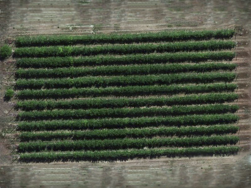
Drones effective tools for fruit farmers
Unmanned aerial vehicles provide reliable, accurate data to growers.
Sharing data for improved forest protection and monitoring
Although the mapping of aboveground biomass is now possible with satellite remote sensing, these maps still have to be calibrated and validated using on-site data gathered by researchers across the world. A newly established global database will support Earth Observation and encourage investment in relevant field-based measurements and research.
Mechanism Modeling for Better Forecasts, Climate Predictions
Modeling currents together with wind and waves provides more accurate predictions for weather forecasts and climate scientists.
Many uses for high-frequency radar in the Great Lakes: warning ships, tracking spills, monitoring algal blooms
Lorelle Meadows is available to discuss high-frequency radar capabilities in freshwater applications and the importance of remote sensing in the Great Lakes. Lorelle Meadows is the dean of the Pavlis Honors College at Michigan Technological University and an oceanographer by…