NASA estimates Hurricane Dorian’s massive Bahama rainfall totals

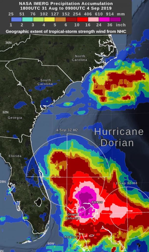
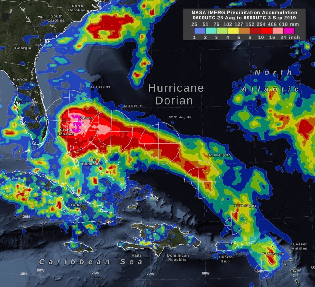
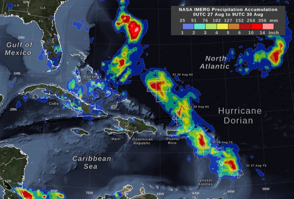
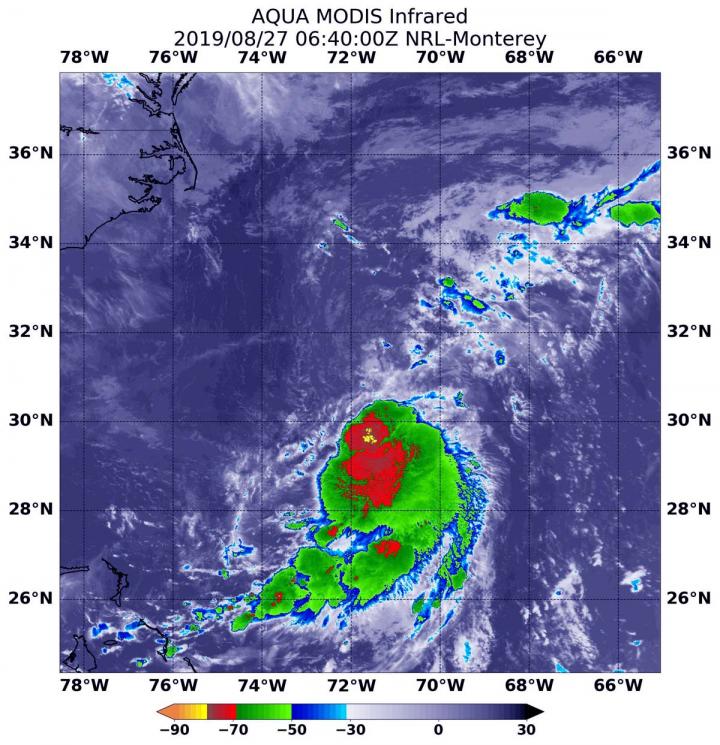
Hurricane Dorian dropped excessive rainfall on the Bahamas and NASA calculated the rainfall the storm generated. “By Wednesday morning, September 4, the rain accumulation from Hurricane Dorian exceeded 36 inches in an area that included parts of Grand Bahama Island…

NASA infrared data reveals rainmaking potential in tropical depression 7

Another Atlantic Ocean basin depression formed while Hurricane Dorian is still wreaking havoc on the Bahamas and affecting the southeastern U.S. Infrared imagery from NASA’s Aqua satellite shows that Tropical Depression 7 in the western Gulf of Mexico has developed…

NASA’s IMERG estimates hurricane Dorian’s rain

In the early hours of Tuesday, September 3, Hurricane Dorian had been stationary over the island of Grand Bahama for 18 hours, most of the time as a category 5 hurricane. Storm-total rain accumulation over parts of Grand Bahama and…

Snowfall frequency declining across Northwest, PSU study finds

With warming temperatures, average snowfall frequency is estimated to decline across the Pacific Northwest by 2100 — and at a faster rate if greenhouse emissions are not reduced, according to a new Portland State University study. Researchers in PSU’s Climate…

GPM analyzes tropical depression Kajiki’s rainfall over Vietnam and Laos

The Global Precipitation Measurement mission or GPM core satellite provided a look at rainfall rates in Tropical Depression Kajiki after it made a quick landfall in Vietnam. On Sept. 2, Kajiki formed as Tropical Depression 16W in the South China…

Major Hurricane Juliette’s emerging eye spotted in NASA satellite imagery

NASA’s Aqua satellite passed over the Eastern Pacific Ocean and provided an image of Hurricane Juliette as its eye began to emerge. Juliette has grown into a major hurricane, about 450 miles southwest of the southern tip of Baja California,…

NASA finds tropical storm 14W strengthening

Tropical Storm 14W formed as a depression a couple of days ago in the Northwestern Pacific Ocean and strengthened into a tropical storm on Sept. 2. Infrared data from NASA’s Aqua satellite shows some powerful thunderstorms fueling further intensification. On…

NASA infrared eye analyzes typhoon Lingling

The storm that became Typhoon Lingling strengthened very quickly in the Northwestern Pacific Ocean and infrared imagery from NASA revealed the powerful thunderstorms fueling that intensification. Lingling formed on Sept. 2 as Tropical Depression 15W and strengthened quickly into a…

Revolutionizing water quality monitoring for our rivers and reef

New, lower-cost help may soon be on the way to help manage one of the biggest threats facing the Great Barrier Reef. That threat is pollution from land making its way downstream by way of the many rivers and streams…

Corals take control of nitrogen recycling

Corals are shown to recycle their own waste ammonium using a surprising source of glucose–a finding that reveals more about the relationship between corals and their symbiotic algae. Symbiosis between corals and algae provides the backbone for building coral reefs,…

Impact of climate change on global banana yields revealed

Climate change could negatively impact banana cultivation in some of the world’s most important producing and exporting countries, a study has revealed. Bananas are recognised as the most important fruit crop – providing food, nutrition and income for millions in…

Deep snow cover in the Arctic region intensifies heat waves in Eurasia

Persistent abnormally hot weather can cause negative impacts on human health, agriculture, and natural environments. A heat wave — a spell of hot days with the mercury rising much higher than the average temperature — has been reported more frequently…

Hurricane Dorian marching slowly across Atlantic

The National Hurricane Center (NHC) in Miami reports that an Air Force plane is finding Dorian a “little stronger” as of the 8:00am EDT advisory put out today, Aug. 30, 2019.  Data from an Air Force Reserve reconnaissance aircraft indicate that…

NASA satellites on-hand as Dorian becomes a category 3 hurricane

As Hurricane Dorian was upgraded to a Category 3 hurricane on the Saffir-Simpson Hurricane Wind Scale, NASA’s fleet of satellites were gathering data during the day to assist weather forecasters and scientists. At 2:00 pm EDT the National Hurricane Center…

Bacteria feeding on Arctic algae blooms can seed clouds

WASHINGTON – New research finds Arctic Ocean currents and storms are moving bacteria from ocean algae blooms into the atmosphere where the particles help clouds form. These particles, which are biological in origin, can affect weather patterns throughout the world,…

UCI-led team creates first high-resolution global map of surface ocean phosphate

Irvine, Calif., Aug. 28, 2019 – An international team of Earth system scientists and oceanographers has created the first high-resolution global map of surface ocean phosphate, a key mineral supporting the aquatic food chain. In doing so, the University of California

Rutgers Coastal Expert Can Discuss ‘King Tide’ in N.J.

New Brunswick, N.J. (Aug. 28, 2019) – Rutgers coastal expert Lisa Auermuller is available for interviews on the “king tide” in New Jersey, which will lead to abnormally high water levels through Labor Day, causing localized tidal flooding and illustrating…

NASA finds wind shear affecting Tropical Depression Erin

Visible and infrared imagery from NASA’s Terra satellite revealed that strong wind shear was adversely affecting Tropical Depression Erin, located about 200 miles off the Carolina coast. On Aug. 27, the Moderate Resolution Imaging Spectroradiometer or MODIS instrument aboard NASA’s…

NASA sees Dorian become a hurricane

NASA’s Terra satellite passed over the northwestern Atlantic Ocean as Dorian reached hurricane status during the afternoon of August 28, 2019. On Aug. 28, 2019 at 1:30 p.m. EDT, the Moderate Resolution Imaging Spectroradiometer or MODIS instrument aboard NASA’s Terra…

The positives of climate change? WVU research shows agricultural, economic possibilities

Depending on your side of the aisle, climate change either elicits doomsday anxiety or unabashed skepticism. Jason Hubbart , director of Institute of Water Security and Science at West Virginia University , takes a more centered approach. He’s studied the…

Chipping away at how ice forms could keep windshields, power lines ice-free

SAN DIEGO, Aug. 27, 2019 — How does ice form? Surprisingly, science hasn’t fully answered that question. Differences in ice formation on various surfaces still aren’t well understood, but researchers today will explain their finding that the arrangements that surface…

NASA analyzes Tropical Storm Dorian day and night

Tropical Storm Dorian was approaching the Leeward Islands when NASA-NOAA’s Suomi NPP satellite passed overhead from space and snapped a visible image of the storm. When Suomi NPP came by again the satellite provided a night-time image from early morning…

NASA finds Tropical Depression battling wind shear off the Carolina coast

Newly formed Tropical Depression 6 in the Atlantic Ocean may have just formed, but it did so under adverse atmospheric conditions. The depression is battling wind shear and it’s apparent on imagery from NASA’s Aqua satellite. Wind shear is a…

NASA-NOAA satellite tracks tropical depression Podul across Philippines

Tropical Depression 13W, now named Podul, was crossing the Philippines from east to west as NASA-NOAA’s Suomi NPP satellite provided a visible image of the storm. Podul’s trek across the country triggered many Philippines warnings on August 27, 2019. Tropical…