Another Atlantic Ocean basin depression formed while Hurricane Dorian is still wreaking havoc on the Bahamas and affecting the southeastern U.S. Infrared imagery from NASA’s Aqua satellite shows that Tropical Depression 7 in the western Gulf of Mexico has developed powerful thunderstorms with heavy rain capabilities. That potential for heavy rainfall includes southern Texas and northeastern Mexico.
NASA conducts research on tropical cyclones and provides various data to forecasters at NOAA’s National Hurricane Center (NHC) to consider in their forecasts.
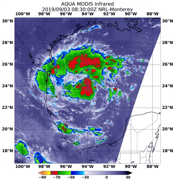
NASA’s Aqua satellite used infrared light to analyze the strength of storms in Tropical Depression 7 and found strongest storms in fragmented bands of thunderstorms north and south of the center. The westernmost extent of those strong storms were already affecting the extreme northeastern coast of Mexico. Infrared data provides temperature information, and the strongest thunderstorms that reach high into the atmosphere have the coldest cloud top temperatures.
On Sept. 3 at 4:30 a.m. EDT (0830 UTC) the Moderate Imaging Spectroradiometer or MODIS instrument that flies aboard NASA’s Aqua satellite found strongest thunderstorms had cloud top temperatures as cold as minus 70 degrees Fahrenheit (minus 56.6 Celsius). Cloud top temperatures that cold indicate strong storms with the potential to generate heavy rainfall.
The NHC said the system is expected to produce the following rainfall totals through Friday:
In northeastern Mexico, 6 to 12 inches of rainfall is possible with isolated totals to 15 inches, highest in the Sierra Madre Oriental of Tamaulipas and Nuevo Leon. This rainfall may cause life-threatening mudslides and flash floods. In south Texas and the lower Texas Coast, 2 to 4 inches are possible with isolated amounts as high as 6 inches.
Tropical Depression 7 (TD7) formed around 5 a.m. EDT today, Sept. 3, 2019 and NHC posted a Tropical Storm Warning from La Pesca to Barra El Mezquital, Mexico.
NHC’s advisory at 11 a.m. EDT (1500 UTC) on Sept. 3 noted that the center of Tropical Depression Seven (TD7) was located near latitude 23.6 degrees north and longitude 94.9 degrees west. The depression is moving toward the west near 7 mph (11 kph), and this motion is expected to continue today.
Maximum sustained winds are near 35 mph (55 km/h) with higher gusts. Slow strengthening is forecast before the system moves inland, and the depression is expected to become a tropical storm by Wednesday. The estimated minimum central pressure is 1004 millibars.
NHC forecasters said a motion toward the west-northwest is forecast tonight and Wednesday. This motion could bring the system near or over the coast of northeastern Mexico late Wednesday.
###
For updated forecasts, visit:
http://www.
nhc.
noaa.
gov
By Rob Gutro
NASA’s Goddard Space Flight Center
This part of information is sourced from https://www.eurekalert.org/pub_releases/2019-09/nsfc-nid090319.php
Rob Gutro
[email protected]
http://www.nasa.gov/goddard

