As Hurricane Dorian was upgraded to a Category 3 hurricane on the Saffir-Simpson Hurricane Wind Scale, NASA’s fleet of satellites were gathering data during the day to assist weather forecasters and scientists. At 2:00 pm EDT the National Hurricane Center (NHC) posted a supplemental advisory. NHC reports that “extremely dangerous Hurricane Dorian poses a significant threat to Florida and the northwestern Bahamas. The Hurricane Hunter plane finds Dorian is now a major hurricane.”
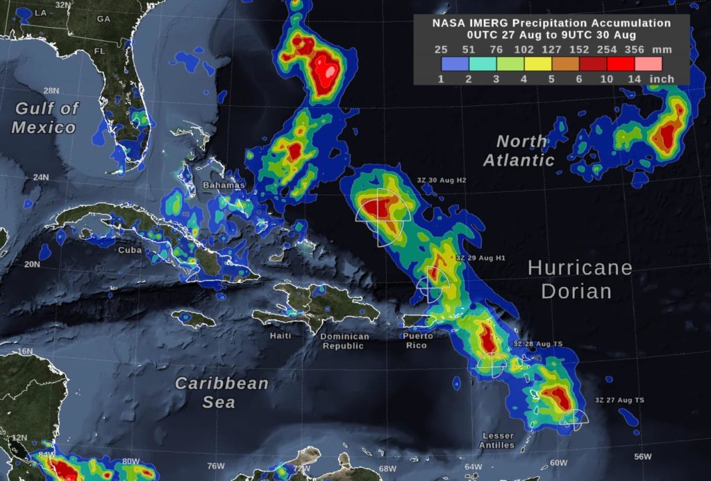
NASA’s Global Precipitation Measurement mission satellite uses its IMERG algorithm with data from a fleet of satellites to provide global estimates of the precipitation within the storm every 30 minutes. This map is showing the estimates early on the morning of August 30 prior to Dorian becoming a Category 3 storm.
NOAA-NASA’s Suomi NPP satellite uses its complement of instruments onboard to dissect storms and provide information on many different aspects of the hurricane including storm strength, cloudtop temperature, circulation, and rainfall, among others, within the structure of the storm. The next three images are all from the Suomi NPP satellite and its instruments which help scientists figure out the intensity of the storm and help predict where it will ultimately end up.
Hurricane Dorian is currently at latitude 24.8N and longitude 70.3W which is about 445 miles (715 km) east of the northwestern Bahamas and about 625 miles (1005 km) east of West Palm Beach, FL. The NHC forecast is: “A slower west-northwestward to westward motion should begin tonight and continue into early next week. On this track, the core of Dorian should move over the Atlantic well north of the southeastern and central Bahamas today and tomorrow, be near or over the northwestern Bahamas on Sunday, and be near the Florida peninsula late Monday.”
Currently the storm’s maximum sustained winds are 115 mph (185 km/h) with higher gusts, and is moving northwest at 10 mph (17 km/h). Hurricane-force winds extend outward up to 25 miles (35 km) from the center and tropical-storm-force winds extend outward up to 105 miles (165 km). The minimum central pressure is 970 mb.
###
The summary of watches and warnings in effect have not changed since the last NHC update at 11:00 am EDT.
For more information and updates, visit:
https:/
/
nhc.
noaa.
gov
By Lynn Jenner
NASA’s Goddard Space Flight Center
This part of information is sourced from https://www.eurekalert.org/pub_releases/2019-08/nsfc-nso083019.php
Lynn Jenner
[email protected]
http://www.nasa.gov/goddard

