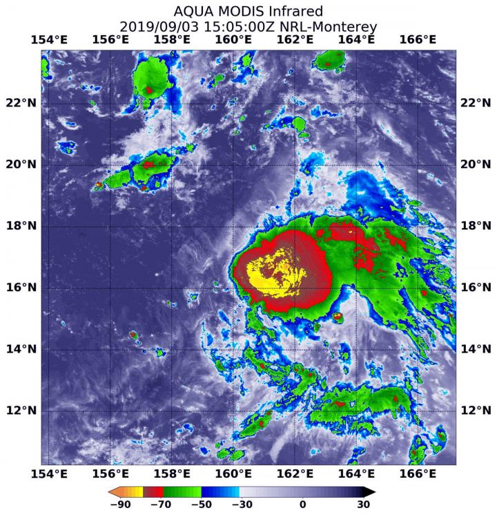
Tropical Storm 14W formed as a depression a couple of days ago in the Northwestern Pacific Ocean and strengthened into a tropical storm on Sept. 2. Infrared data from NASA’s Aqua satellite shows some powerful thunderstorms fueling further intensification.
On Sept. 3 at 1:05 p.m. EDT (1505 UTC), the Moderate Imaging Spectroradiometer or MODIS instrument that flies aboard NASA’s Aqua satellite used infrared light to analyze the strength of storms within the 14W. NASA researches these storms to determine how they rapidly intensify, develop and behave. In the data obtained about 14W, the very strong storms found near the center indicate the storm is strengthening.
Tropical cyclones are made of up hundreds of thunderstorms, and infrared data can show where the strongest storms are located. They can do that because infrared data provides temperature information, and the strongest thunderstorms that reach highest into the atmosphere have the coldest cloud top temperatures.
MODIS found those strongest storms were around the center of circulation where cloud top temperatures were as cold as minus 80 degrees Fahrenheit (minus 62.2 Celsius). NASA research has found that cloud top temperatures that cold indicate strong storms with the potential to generate heavy rainfall.
The Joint Typhoon Warning Center (JTWC) noted that, animated enhanced infrared satellite imagery shows that the low-level circulation center of the storm is exposed to outside winds, and that the strongest thunderstorms are being pushed to the eastern side of the storm, because of westerly winds. A microwave image at 6:47 a.m. EDT (1047 UTC) indicates tightly curved shallow banding of thunderstorms wrapping into the center with an isolated area of strong storms over the southeastern quadrant.
On Sept. 3 at 11 a.m. EDT (1500 UTC), Tropical Storm 14W had maximum sustained winds near 35 knots (40 mph/65 mph). 14W is far from land areas and is about 1,566 nautical miles southeast of Yokosuka, Japan. 14W is moving to the west.
JTWC said 14W will move west-northwest across the Pacific Ocean. The JTWC expects the system will gradually intensify to 90 knots after five days and move toward Japan.
###
By Rob Gutro
NASA’s Goddard Space Flight Center
This part of information is sourced from https://www.eurekalert.org/pub_releases/2019-09/nsfc-nft090319.php
Rob Gutro
[email protected]
http://www.nasa.gov/goddard

