Hurricane Dorian dropped excessive rainfall on the Bahamas and NASA calculated the rainfall the storm generated.
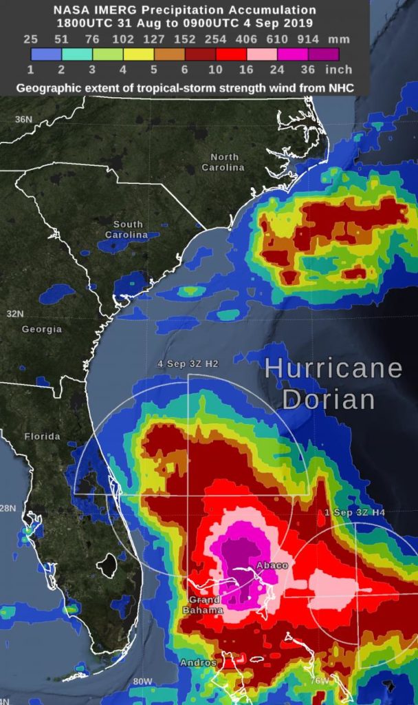
“By Wednesday morning, September 4, the rain accumulation from Hurricane Dorian exceeded 36 inches in an area that included parts of Grand Bahama Island and Abaco Island,” said Owen Kelley, researcher at NASA Goddard. “By that time, the Dorian’s center was north of the Bahamas and was moving further north, approximately parallel to Florida’s east coast.”
NASA Estimating Rainfall
NASA has the ability to peer under the clouds of a tropical cyclone and estimate the rainfall rates occurring in a storm or how much rain has fallen. Rainfall imagery was generated using the Integrated Multi-satEllite Retrievals for GPM or IMERG product at NASA’s Goddard Space Flight Center in Greenbelt, Maryland. These near-realtime rain estimates come from the NASA IMERG algorithm, which combines observations from a fleet of satellites in the GPM or Global Precipitation Measurement mission constellation of satellites, and is calibrated with measurements from the GPM Core Observatory as well as rain gauge networks around the world. The measurements are done in near-real time, to provide global estimates of precipitation every 30 minutes.
The storm-total rainfall at a particular location varies with the forward speed of the hurricane, with the size of the hurricane’s wind field, and with how vigorous the updrafts are inside the hurricane.
During the past day, the maximum sustained surface winds speed (Dorian’s intensity) decreased from category 5 to category 2 on the Saffir-Simpson scale. At the same time, the geographic extent of tropical-storm strength winds increased significantly.
Warnings and Watches on Sept. 4
NOAA’s National Hurricane Center (NHC) posted many warnings and watches as Dorian continues to move north along the U.S. East Coast.
A Storm Surge Warning is in effect for Sebastian Inlet, FL to Surf City, NC. A Storm Surge Watch is in effect from north of Surf City, NC to Poquoson, VA, including Hampton Roads, Pamlico and Albemarle Sounds and the Neuse and Pamlico Rivers.
A Hurricane Warning is in effect for Volusia/Brevard County, FL line to Ponte Vedra Beach, FL and from north of the Savannah River to Surf City, NC. A Hurricane Watch is in effect from north of Ponte Vedra Beach, FL to the Savannah River, from north of Surf City, NC to the North Carolina/Virginia border and for the Albemarle and Pamlico Sounds.
A Tropical Storm Warning is in effect from the Sebastian Inlet, FL to the Volusia/Brevard County, FL line and from north of Ponte Vedra Beach, FL to Savannah River. A Tropical Storm Watch is in effect from the North Carolina/Virginia border to Chincoteague, VA and for Chesapeake Bay from Smith Point southward.
NHC: Dorian’s Status on Sept. 4
At 8 EDT (1200 UTC) on Sept. 4, NHC said the center of Hurricane Dorian was located near latitude 29.5 degrees north and longitude 79.6 degrees west. Dorian is about 95 miles (155 km) east-northeast of Daytona Beach, Florida.
Because hurricane-force winds extend outward up to 60 miles (95 km) from the center, and tropical-storm-force winds extend outward up to 175 miles (280 km), Daytona was experiencing those tropical-storm-force winds at 8 a.m. EDT.
Dorian is moving toward the north-northwest near 8 mph (13 kph), and a northwest or north-northwest motion is expected through this morning. Maximum sustained winds are near 105 mph (165 kph) with higher gusts. Some weakening is expected during the next couple of days. However, Dorian is expected to remain a powerful hurricane during the next few days. The minimum central pressure reported by an Air Force Reserve Unit Hurricane Hunter aircraft is 964 millibars.
NOAA’s Forecasts
NHC said, “A turn toward the north is forecast by this evening, followed by a turn toward the north-northeast on Thursday morning. On this track, the core of Hurricane Dorian will move dangerously close to the Florida east coast and the Georgia coast through tonight. The center of Dorian is forecast to move near or over the coast of South Carolina and North Carolina Thursday through Friday morning.”
For updated forecasts, visit NOAA’s NHC:
http://www.
nhc.
noaa.
gov
###
This part of information is sourced from https://www.eurekalert.org/pub_releases/2019-09/nsfc-neh090419.php
Rob Gutro
[email protected]
http://www.nasa.gov/goddard

