Tropical Storm Isaias made landfall late on Aug. 3 and by today, Aug. 4, the huge storm stretched from Virginia to Maine. NASA satellites have been providing forecasters with rainfall rates, cloud top temperatures, storm extent and strength as Isaias…
Tag: Climate Science
Dartmouth receives DOE funding to develop concentrated solar power system
Engineers at Dartmouth have received a three-year $750,000 grant from the U.S. Department of Energy (DOE) to develop a new high-temperature tubing material for a concentrated solar power (CSP) system using a patented alloy developed at Dartmouth that could both…
Germany-wide rainfall measurements by utilizing the mobile network
Rainfall maps with high temporal resolution derived from the attenuation of commercial microwave links (CMLs) by precipitation
Atmospheric and earth system research with special halo aircraft to continue
DFG extends funding by another six years
Study calls for urgent plan to manage invasive weed which threatens livelihoods in Africa
CABI scientists have conducted research which is calling for an urgent integrated management strategy, including biological control, to fight the invasive weed Mimosa diplotricha which is threatening livelihoods in eastern and southern Africa
COVID-19: Lower incidence at high altitudes?
New Rochelle, NY, August 3, 2020–Despite recent reports of lower COVID-19 incidence among high-altitude populations, current data is insufficient to conclude that high altitude is protective against the SARS-CoV-2 virus, as reported in the peer-reviewed journal High Altitude Medicine &…
NASA finds an eye and a giant ‘tail’ in Typhoon Hagupit
NASA-NOAA’s Suomi NPP satellite provided forecasters with a visible image of Typhoon Hagupit in the Northwestern Pacific Ocean that showed the development of an eye as it quickly intensified. Imagery also showed a thick band of thunderstorms that resembled a…
NASA puts visible and water vapor eyes on Tropical Storm Isaias
NASA’s Aqua satellite obtained visible and water vapor imagery as Tropical Storm Isaias continued moving along the east coast of Florida. On Aug. 3, Warnings and Watches stretched from Florida to Maine. NASA Satellite View: Isaiah’s Organization The Moderate Resolution…
NASA satellites show two views of California’s Apple Fire
NASA’s satellites were working overtime as they snapped pictures of the large Apple Fire in Banning Canyon near San Bernardino, California on Aug. 02, 2020. This fire began on July 31, 2020 and the cause of the fire is still…
‘Worst-case’ CO2 emissions scenario is best for assessing climate risk and impacts to 2050
RCP 8.5 tracks within 1% of actual emissions
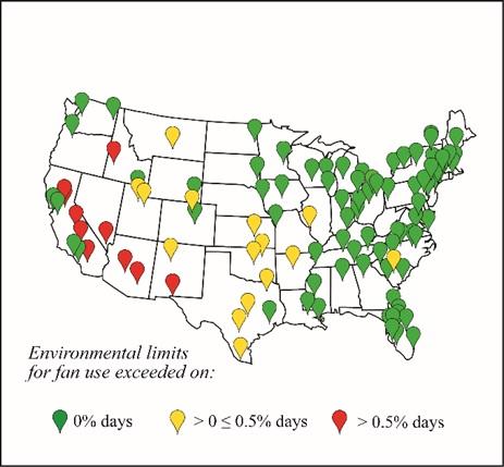
US should consider ‘stay-at-home’ cooling options during pandemic
A new study from Australian scientists at the forefront of climate and health modelling suggests electric fans and water dousing could be a viable stay-at-home cooling strategy as the United States (US) anticipates extreme heat.
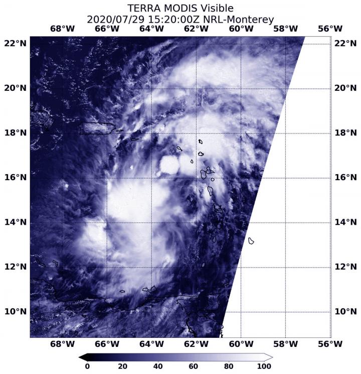
NASA follows potential tropical cyclone 9 into eastern Caribbean
NASA’s Terra satellite obtained visible imagery of Potential Tropical Cyclone 9 after it moved into the Eastern Caribbean Sea and continued bringing heavy rainfall and gusty winds to the Leeward Islands, the U.S. and British Virgin Islands and Puerto Rico.
Decreased iron levels in seawater make mussels loosen their grip
Mussels secrete sticky plaques that help them attach to wet surfaces, such as rocks on the beach. These adhesive structures are rich in iron, which is thought to help make the attachments strong yet flexible. Now, researchers reporting in Environmental…
Newer PFAS compound detected for first time in Arctic seawater
Per- and polyfluoroalkyl substances (PFAS), found in many household products and food packages, have raised concerns because of their persistence and possible toxicity to people and wildlife. Because the compounds don’t break down naturally, they have become environmental contaminants. Now,…
Scientists record rapid carbon loss from warming peatlands
Scientists at the Department of Energy’s Oak Ridge National Laboratory have demonstrated a direct relationship between climate warming and carbon loss in a peatland ecosystem.
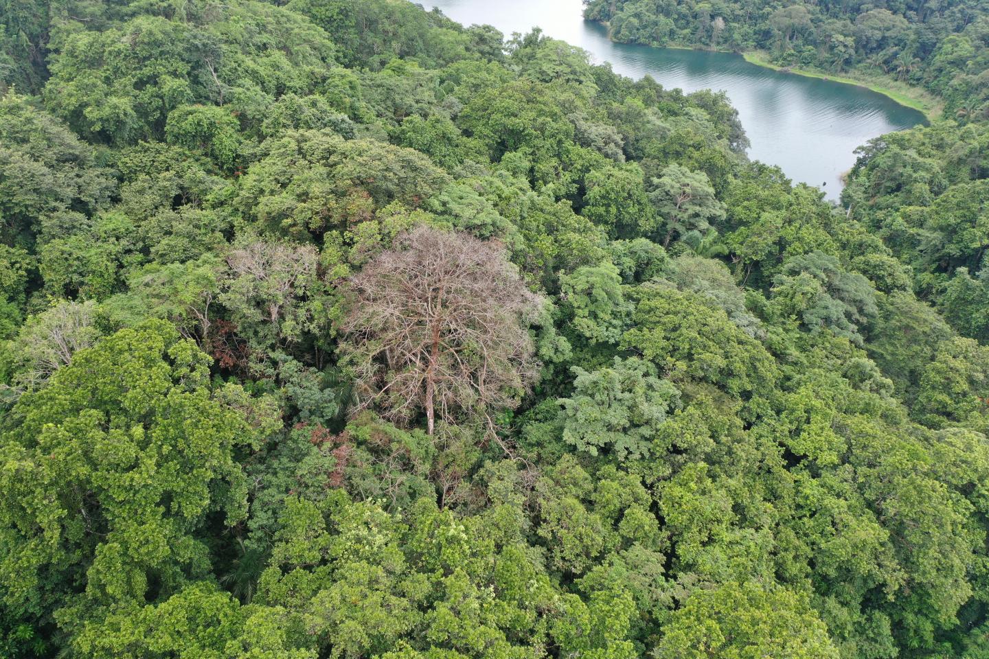
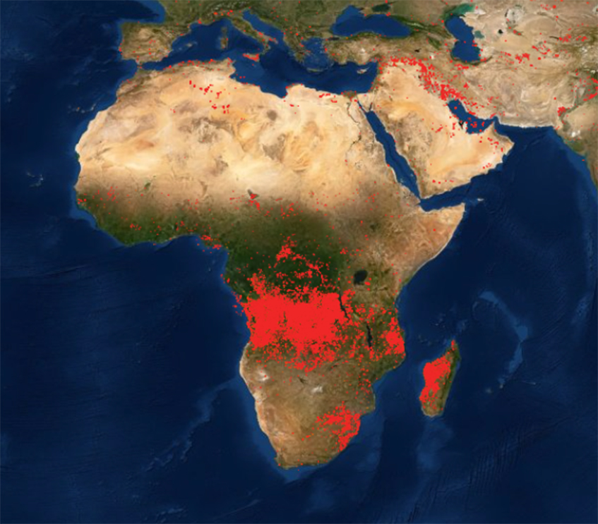
Lightning strikes more than 100 million times per year in the tropics
Researchers at the Smithsonian Tropical Research Institute (STRI) in Panama have published dramatic maps showing the locations of lightning strikes across the tropics in Global Change Biology.
Lightning strikes more than 100 million times per year in the tropics
Researchers at the Smithsonian Tropical Research Institute (STRI) in Panama have published dramatic maps showing the locations of lightning strikes across the tropics in Global Change Biology . Based on ground and satellite data, they estimate that more than 100…
Where are arctic mosquitoes most abundant in Greenland and why?
Examining the population dynamics during the larval life stage of these pests
NASA examines Tropical Storm Gonzalo’s structural changes
Visible and microwave imagery from NASA’s Aqua satellite indicated Tropical Storm Gonzalo was slightly less organized than it was on the previous day. Gonzalo formed in the central North Atlantic Ocean on July 21 and is moving west. The Moderate…
NASA finds strength in new Gulf Tropical Depression 8
NASA’s Aqua satellite used infrared light to identify the strongest storms and coldest cloud top temperatures in Tropical Depression 8, spinning in the Gulf of Mexico. Tropical Depression 8 formed in the Gulf about 530 miles (855 km) east-southeast of…
NASA sees compact Douglas strengthening to a major hurricane
Although a compact storm, hurricane Douglas in the Eastern Pacific is mighty, as it has become the season’s first major hurricane. NASA-NOAA’s Suomi NPP satellite provided forecasters with an image of Douglas that showed development of an eye as it…
Plastic flow into ocean expected to triple by 2040, action could stem tide more than 80%
Research lays out viable pathway to ‘break the plastic wave’
MIT Press’s New Environmental History book: The Contamination of the Earth
A History of Pollutions in the Industrial Age

International analysis narrows range of climate’s sensitivity to CO2
The most advanced and comprehensive analysis of climate sensitivity yet undertaken has revealed with more confidence than ever before how sensitive the Earth’s climate is to carbon dioxide.
International analysis narrows range of climate’s sensitivity to CO2
Four years of research confidently narrows range of 1.5°C-4.5°C down to 2.3°C-3.9°C
Mitigation of greenhouse gases in dairy cattle through genetic selection
Study targets reducing methane production by 20 percent in 10 years according to research in the Journal of Dairy Science®
Climate predictions several years into the future?
A study from Kiel reveals potential and mechanisms
NASA infrared confirms Douglas still a tropical storm
Infrared data from NASA’s Terra satellite showed that dry air around Tropical Storm Douglas has been inhibiting it from strengthening into a hurricane. On July 22 at 2:15 a.m. EDT (0615 UTC), the Moderate Resolution Imaging Spectroradiometer or MODIS instrument…
NASA sees record-breaking new Tropical Storm Gonzalo strengthening
The seventh named tropical cyclone of the North Atlantic Ocean has formed, and like some others this season, it has broken a record. NASA’s Aqua satellite provided a look at the small record-breaker. The National Hurricane Center (NHC) reports that…
Discovery of first active seep in Antarctica provides new understanding of methane cycle
CORVALLIS, Ore. – The discovery of the first active methane seep in Antarctica is providing scientists new understanding of the methane cycle and the role methane found in this region may play in warming the planet. A methane seep is…
New study shows retreat of East Antarctic ice sheet during previous warm periods
Evidence of glacial retreat in the Wilkes Basin 400,000 years ago suggests ice loss in this region could add 10 to 13 feet (3 to 4 meters) to future global sea level rise
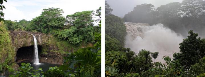
New research reveals how hurricane Lane brought fire and rain to Hawaiian islands
Hurricane Lane was an impactful event for the Hawaiian Islands.
NASA finds wind shear and cooler waters winding down Tropical Depression 7E
NASA-NOAA’s Suomi NPP satellite passed over the Eastern Pacific Ocean and provided forecasters with a visible image of the waning Tropical Depression 7E. Wind shear and cooler waters were taking their toll on the storm. The Visible Infrared Imaging Radiometer…
Tropical Storm Douglas organizing in NASA infrared imagery
Tropical Depression 8E developed on July 20 and quickly organized into a tropical storm. Infrared NASA satellite imagery revealed that Tropical Storm Douglas contained strong storms and showed banding of thunderstorms around its center. Tropical Depression 8E formed about 905…
Aerosols have an impact on the solar power yield in Europe
A joint research project of KIT, the German Weather Service, and meteocontrol investigates how tiny suspended particles in the air change the weather and the solar irradiance
NASA finds wind shear and cooler waters winding down Tropical Depression 7E
NASA-NOAA’s Suomi NPP satellite passed over the Eastern Pacific Ocean and provided forecasters with a visible image of the waning Tropical Depression 7E. Wind shear and cooler waters were taking their toll on the storm. The Visible Infrared Imaging Radiometer…
Tropical Storm Douglas organizing in NASA infrared imagery
Tropical Depression 8E developed on July 20 and quickly organized into a tropical storm. Infrared NASA satellite imagery revealed that Tropical Storm Douglas contained strong storms and showed banding of thunderstorms around its center. Tropical Depression 8E formed about 905…
Geoengineering is Just a Partial Solution to Fight Climate Change
Could we create massive sulfuric acid clouds that limit global warming and help meet the 2015 Paris international climate goals, while reducing unintended impacts? Yes, in theory, according to a Rutgers co-authored study in the journal Earth System Dynamics. Spraying sulfur dioxide into the upper atmosphere at different locations, to form sulfuric acid clouds that block some solar radiation, could be adjusted every year to keep global warming at levels set in the Paris goals. Such technology is known as geoengineering or climate intervention.
NASA analyzes new eastern Pacific Ocean Tropical Depression 7E
The seventh tropical depression of the Eastern Pacific Ocean has formed. NASA’s Terra satellite used infrared light to identify the area of strongest storms and coldest cloud top temperatures in Tropical Depression 7E. Tropical Depression 7E formed in the Eastern…
Plant roots increase carbon emission from permafrost soils
A key uncertainty in climate projections is the amount of carbon emitted by thawing permafrost in the Arctic. Plant roots in soil stimulate microbial decomposition, a mechanism called the priming effect. An international research team co-lead by Frida Keuper from…
New research reveals how hurricane Lane brought fire and rain to Hawaiian islands
Hurricane Lane was an impactful event for the Hawaiian Islands. In August 2018, over a four-day period, the island of Hawai’i received an average of 17 inches of rainfall, with a four-day single-station maximum of 57 inches, making Hurricane Lane…
Reduction in commercial flights due to COVID-19 leading to less accurate weather forecasts
Weather forecasts have become less accurate during the COVID-19 pandemic due to the reduction in commercial flights, according to new research.
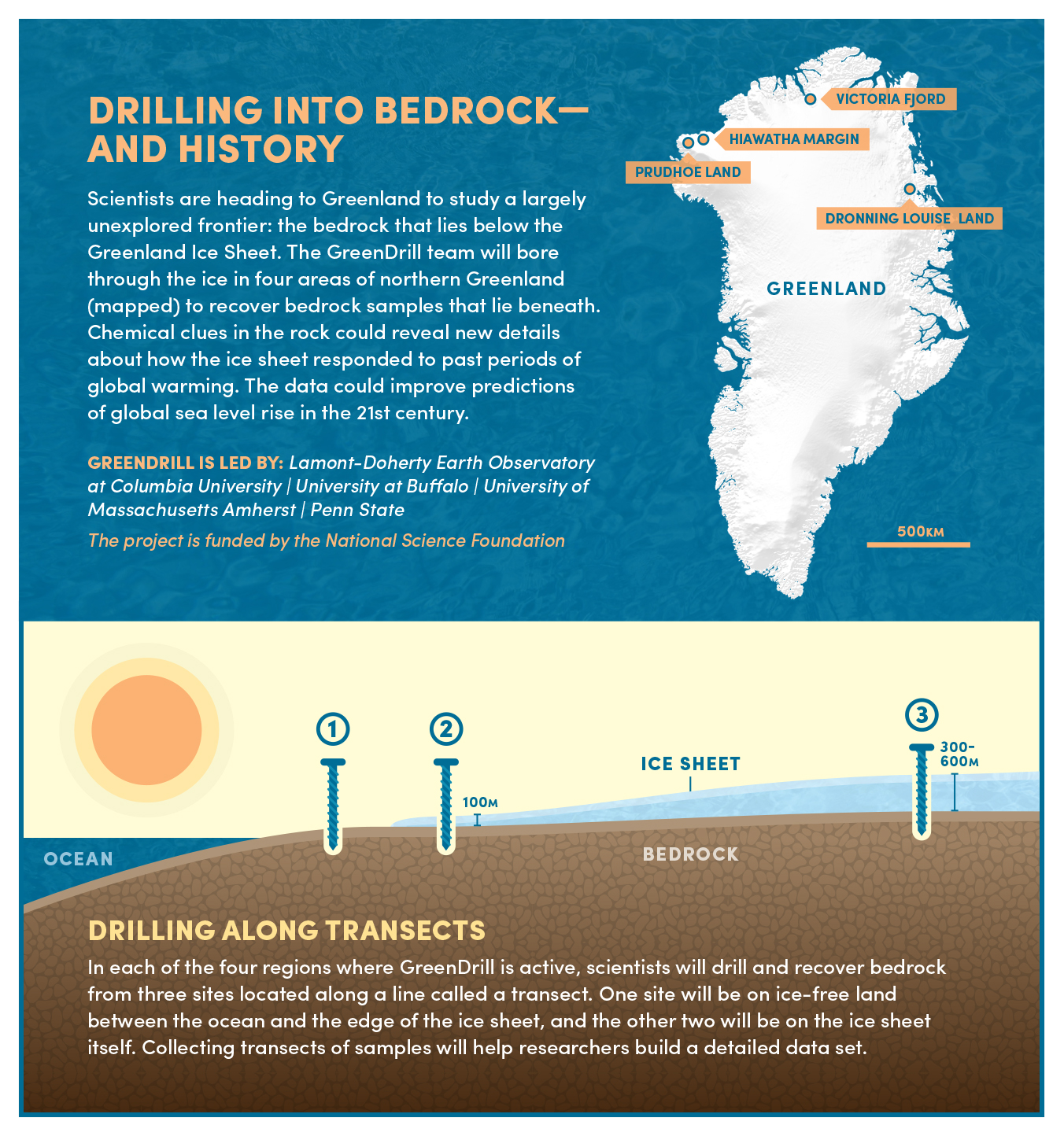
Bedrock drilling project to unlock Greenland Ice Sheet’s secrets
The GreenDrill team aims to unearth new details about the history of the Greenland Ice Sheet. The data could improve predictions of how much global sea levels will rise in the 21st century as ice sheets shrink, researchers say.
Antarctica more widely impacted than previously thought
Antarctica is considered one of the Earth’s largest, most pristine remaining wildernesses. Yet since its formal discovery 200 years ago, the continent has seen accelerating and potentially impactful human activity.
COVID-19 lockdown reduced dangerous air pollutants in five Indian cities by up to 54 percent
A team of 10 interdisciplinary researchers from the University of Surrey’s renowned Global Centre for Clean Air Research (GCARE), including PhD students and post-doctoral researchers, have united to develop a rapid assessment of the impact COVID-19 has had on air quality.
Revealing winners & losers in projected future climates
New research reveals how winners & losers from climate change can be identified based on their ability to adapt to rising future temperatures.
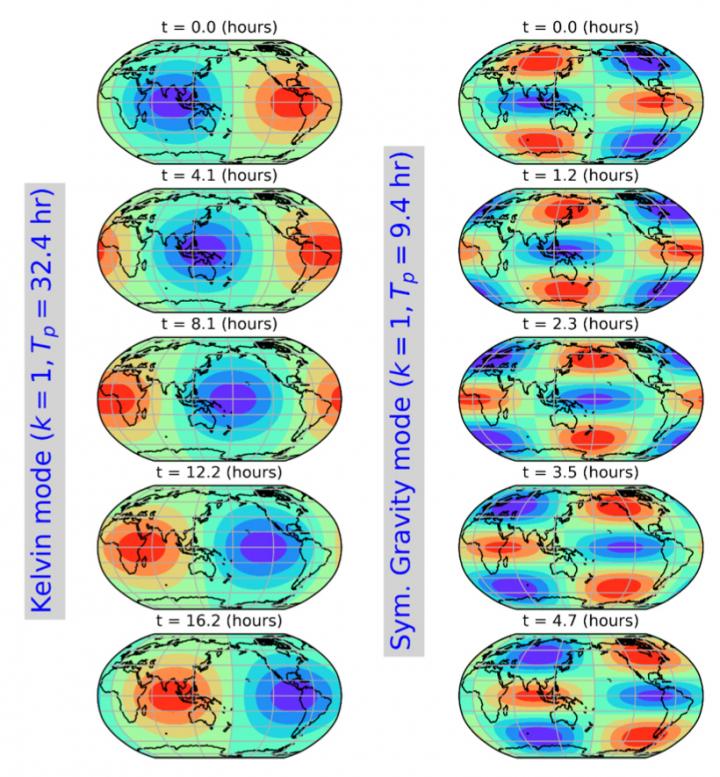
New study detects ringing of the global atmosphere
A ringing bell vibrates simultaneously at a low-pitched fundamental tone and at many higher-pitched overtones, producing a pleasant musical sound.

Future Texas hurricanes: Fast like Ike or slow like Harvey?
Climate change will intensify winds that steer hurricanes north over Texas in the final 25 years of this century, increasing the odds for fast-moving storms like 2008’s Ike compared with slow-movers like 2017’s Harvey, according to new research.
Tree rings show unprecedented rise in extreme weather in South America
Scientists have filled a gaping hole in the world’s climate records by reconstructing 600 years of soil-moisture swings across southern and central South America.
Story Tips: Predicting fire risk, solid state stability check and images in a flash
ORNL Story Tips: Predicting fire risk, solid state stability check and images in a flash