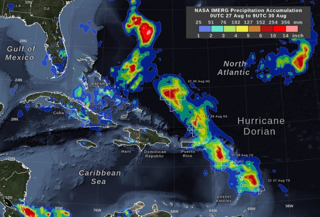
Hurricane Dorian continues to generate tremendous amounts of rainfall, and has left over three feet of rain in some areas of the Bahamas and is now lashing the Carolinas. NASA’s IMERG product provided a look at those rainfall totals. By…
news, journals and articles from all over the world.
Hurricane Dorian continues to generate tremendous amounts of rainfall, and has left over three feet of rain in some areas of the Bahamas and is now lashing the Carolinas. NASA’s IMERG product provided a look at those rainfall totals. By…
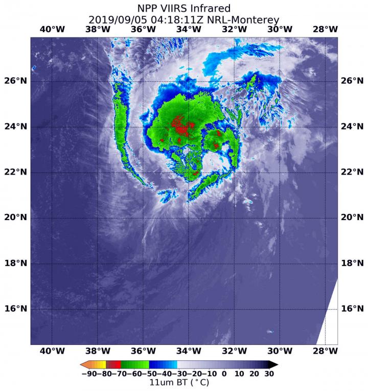
NASA-NOAA’s Suomi NPP satellite passed over the eastern Atlantic Ocean and infrared data revealed that the storm was being adversely affected by wind shear, pushing its strongest storms northeast of its center. NASA-NOAA’s Suomi NPP satellite used infrared light to…
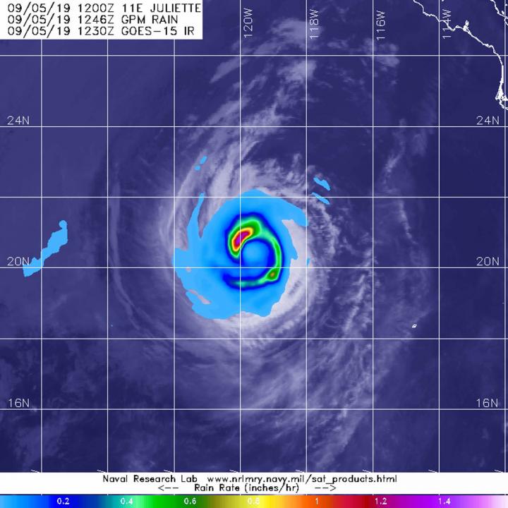
From its vantage point in orbit around the Earth, when the Global Precipitation Measurement mission or GPM core satellite passed over the Eastern Pacific Ocean, it gathered data on rainfall rates occurring in Hurricane Juliette. The areas of strongest rainfall…
In the wet-dry topics of Australia, drinking water in remote communities is often sourced from groundwater bores. The geochemistry of that groundwater impacts the occurrence of opportunistic pathogens in the drinking water supply, researchers now report in PLOS Neglected Tropical…
How much water single-family residences use is closely related to a community’s built environment, according to a University of Arizona-led study. In particular, design factors such as vegetated land cover, housing density and lot size appear to have a strong…
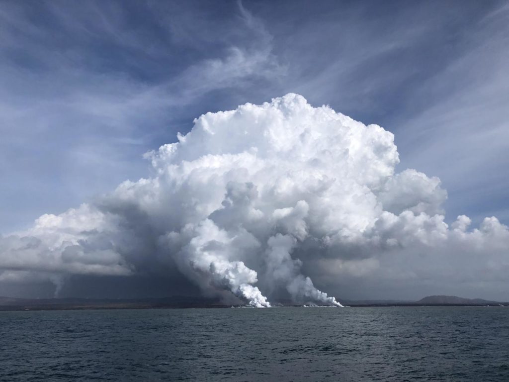
When Kīlauea Volcano erupted in 2018, it injected millions of cubic feet of molten lava into the nutrient-poor waters off the Big Island of Hawai’i. The lava-impacted seawater contained high concentrations of nutrients that stimulated phytoplankton growth, resulting in an…

The massive 2018 eruption set off an unusual effect: An algae super bloom that stretched for miles a

Tropical Storm 14W has been moving through the Northwestern Pacific Ocean for several days and has now been renamed Faxai. NASA’s Aqua satellite passed over the newly renamed storm and took the temperature of Faxai’s clouds and storms. NASA’s Terra…
The eastern Pacific Ocean margin stretching from Mexico to southern Chile offers seismologists a “natural laboratory” in which to study and test ideas about the processes of subduction zones, which are associated with some of the world’s largest recorded earthquakes…
One of the planet’s most active ecosystems is one most people rarely encounter and scientists are only starting to explore. The open ocean contains tiny organisms — phytoplankton — that perform half the photosynthesis on Earth, helping generate oxygen for…
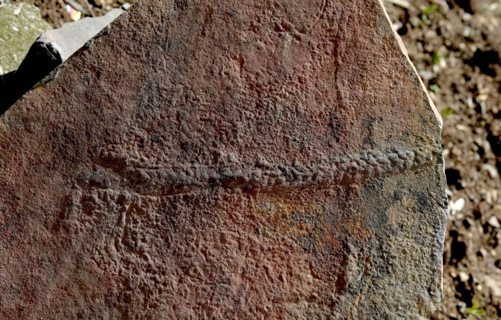
In a remarkable evolutionary discovery, a team of scientists co-led by a Virginia Tech geoscientist has discovered what could be among the first trails made by animals on the surface of the Earth roughly a half-billion years ago. Shuhai Xiao,…
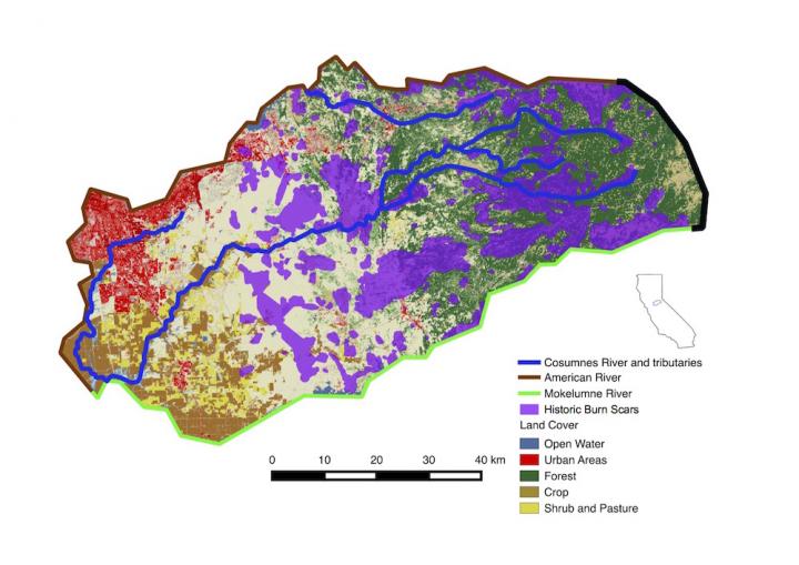
New Berkeley Lab study uses supercomputers to analyze hydrological changes in a California watershed

Shrimp consume snails that carry schistosomiasis which affects 220 million people
Researchers present a new paradigm for understanding how pressures in planets evolve

The Global Precipitation Measurement mission or GPM core satellite provided information about the rate in which rain was falling within the Eastern Atlantic Ocean’s latest tropical storm, Gabrielle. Tropical Depression 8 formed around 5 p.m. EDT on Tuesday, Sept. 3.…

NASA’s Aqua satellite provided forecasters at the National Hurricane Center with infrared data and cloud top temperature information for Tropical Storm Fernand as it was making landfall in northeastern Mexico. Those temperatures indicated Fernand’s rainmaking capabilities. The infrared data also…
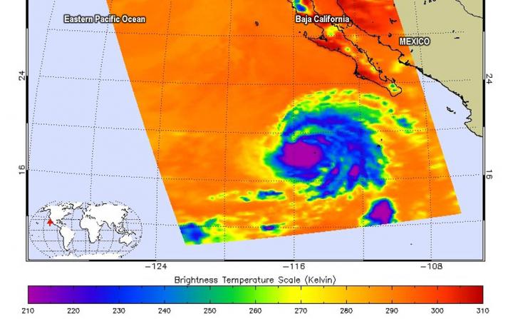
Although Hurricane Juliette is no longer a major hurricane in the Eastern Pacific Ocean, NASA’s Aqua satellite revealed there are still powerful thunderstorms around its center and captured an image of the storm over Socorro Island, Mexico. Aqua provided forecasters…
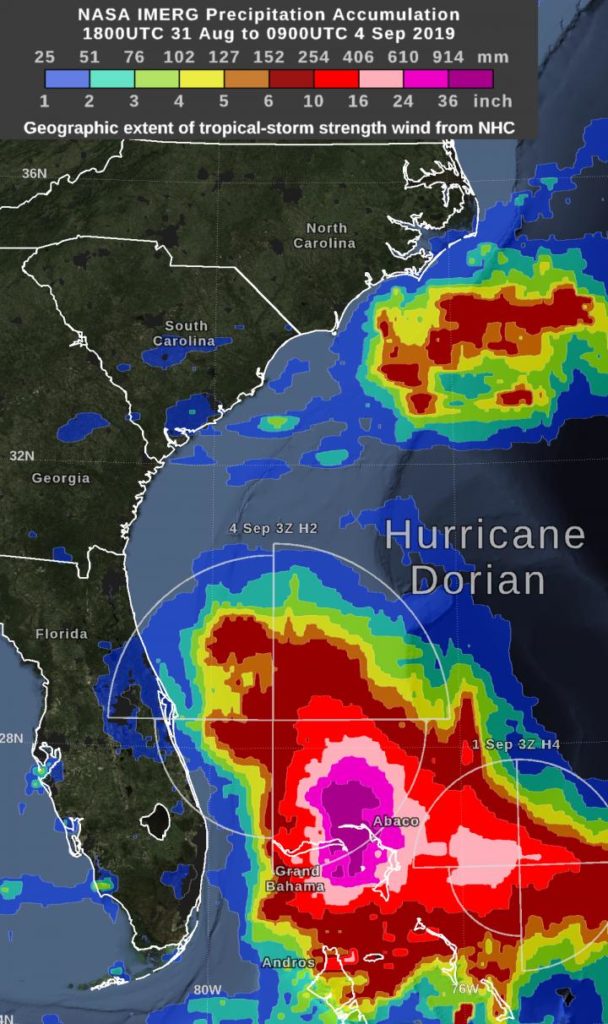
Hurricane Dorian dropped excessive rainfall on the Bahamas and NASA calculated the rainfall the storm generated. “By Wednesday morning, September 4, the rain accumulation from Hurricane Dorian exceeded 36 inches in an area that included parts of Grand Bahama Island…
Taxes that incentivize environmentally friendly practices could promote green development
In summer heat, cities may swelter more than nearby suburbs and rural areas. And while the size of this urban heat island effect varies widely among the world’s cities, heat island intensity can largely be explained by a city’s population…
Earthquake study casts doubt on early warnings but hints at improved forecasting
Scientists describe complex oxygen absorption system
Concrete may be what humans use to construct safe places to live and work when we go to the Moon or
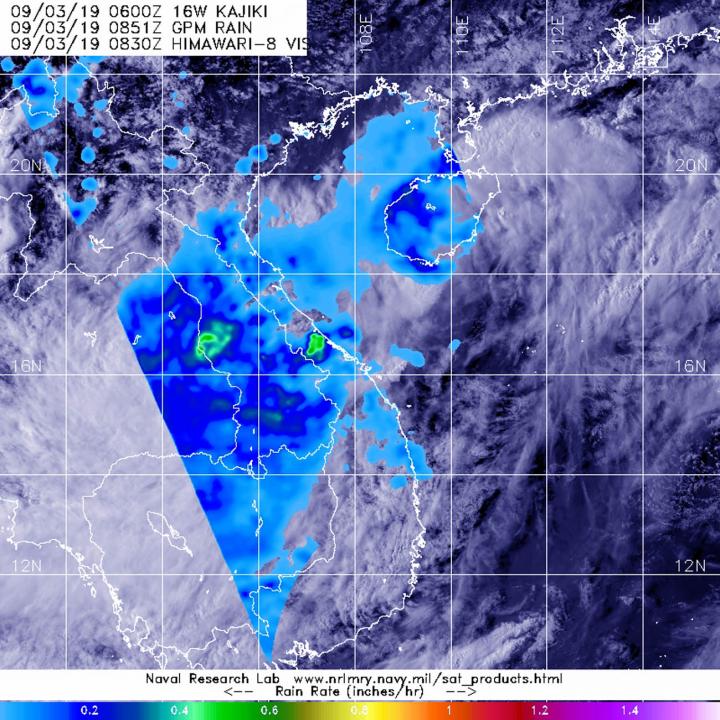
The Global Precipitation Measurement mission or GPM core satellite provided a look at rainfall rates in Tropical Depression Kajiki after it made a quick landfall in Vietnam. On Sept. 2, Kajiki formed as Tropical Depression 16W in the South China…

NASA’s Aqua satellite passed over the Eastern Pacific Ocean and provided an image of Hurricane Juliette as its eye began to emerge. Juliette has grown into a major hurricane, about 450 miles southwest of the southern tip of Baja California,…
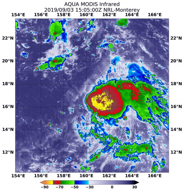
Tropical Storm 14W formed as a depression a couple of days ago in the Northwestern Pacific Ocean and strengthened into a tropical storm on Sept. 2. Infrared data from NASA’s Aqua satellite shows some powerful thunderstorms fueling further intensification. On…
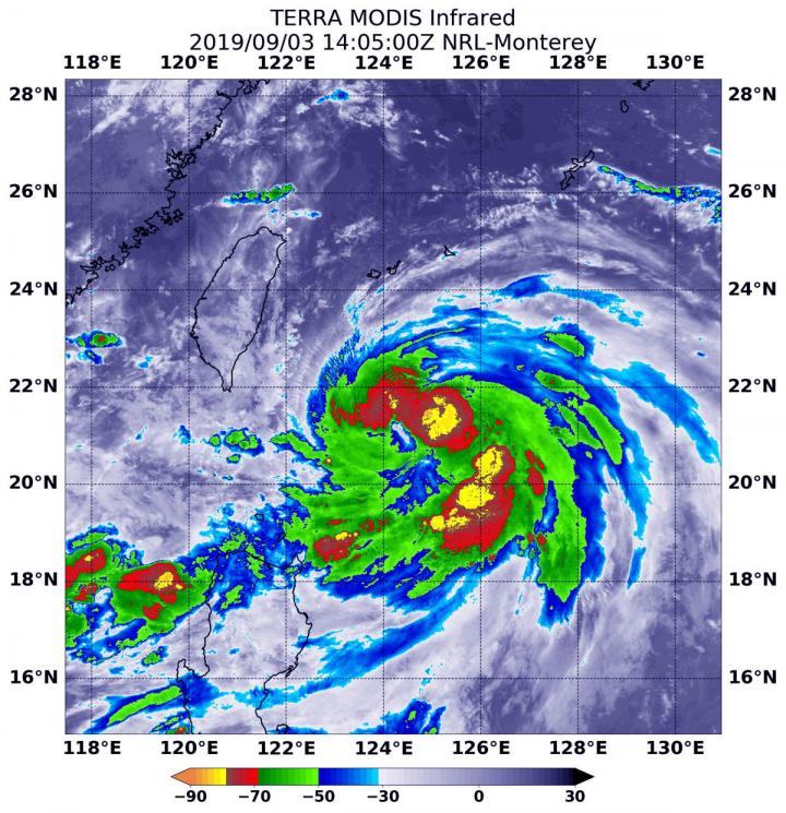
The storm that became Typhoon Lingling strengthened very quickly in the Northwestern Pacific Ocean and infrared imagery from NASA revealed the powerful thunderstorms fueling that intensification. Lingling formed on Sept. 2 as Tropical Depression 15W and strengthened quickly into a…
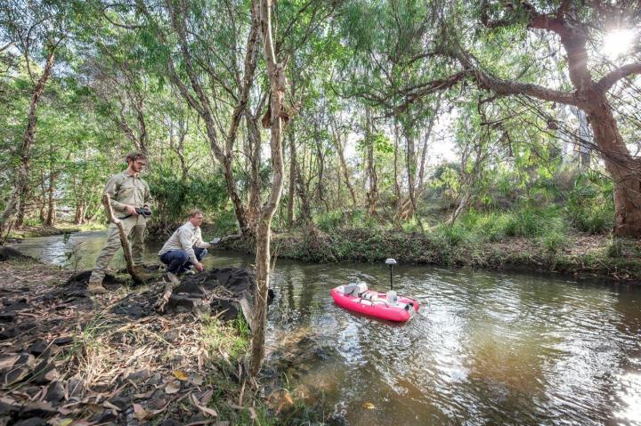
New, lower-cost help may soon be on the way to help manage one of the biggest threats facing the Great Barrier Reef. That threat is pollution from land making its way downstream by way of the many rivers and streams…

A deep drilling project at Lake Ohrid, situated at the border between Albania and North Macedonia and involving 47 researchers from 13 nations, has brought new insights into climate history to light. The team, headed by the geologist Professor Dr…
Interactive map of Europe
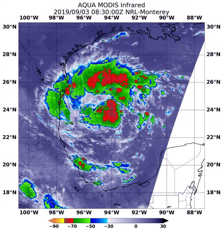
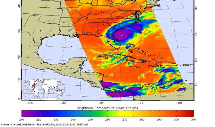
Another Atlantic Ocean basin depression formed while Hurricane Dorian is still wreaking havoc on the Bahamas and affecting the southeastern U.S. Infrared imagery from NASA’s Aqua satellite shows that Tropical Depression 7 in the western Gulf of Mexico has developed…
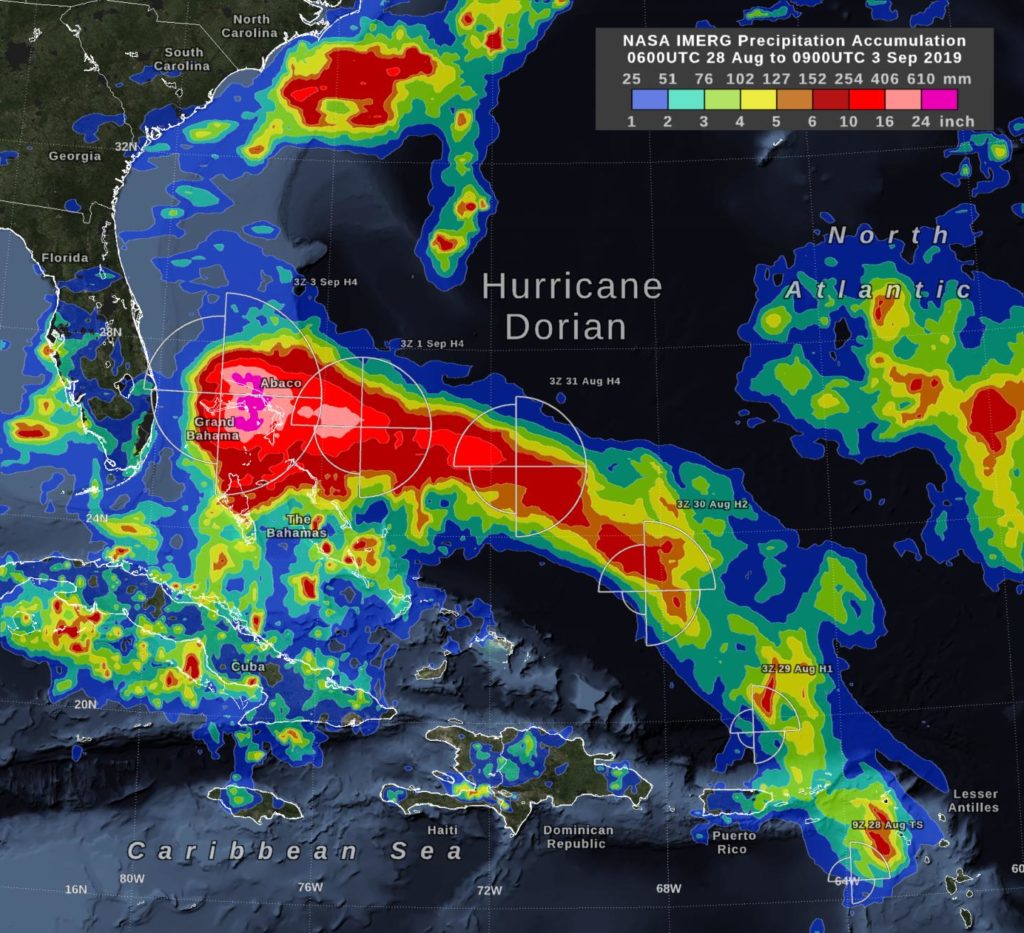
In the early hours of Tuesday, September 3, Hurricane Dorian had been stationary over the island of Grand Bahama for 18 hours, most of the time as a category 5 hurricane. Storm-total rain accumulation over parts of Grand Bahama and…
With warming temperatures, average snowfall frequency is estimated to decline across the Pacific Northwest by 2100 — and at a faster rate if greenhouse emissions are not reduced, according to a new Portland State University study. Researchers in PSU’s Climate…
New study shows an increasingly high probability of more frequent, more extreme concurrent soil drou
A study examines how anthropogenic and climate stressors correlate with local mammalian extinction. Although human activity and global warming are thought to be responsible for the rapid extinction of mammalian species, long-term data on the links is sparse. Zhibin Zhang…
Researchers digitized more than 400,000 line-km of archival Antarctic ice-penetrating radar data, originally recorded in the 1970s on 35-mm optical film, and deposited the digitized record into a public archive, enabling the archival data to be compared with modern radar…
Climate simulations suggest that land-atmosphere feedbacks involving soil moisture effects on atmospheric temperature and humidity can increase the frequency and intensity of atmospheric aridity, leading to a high probability of concurrent soil drought and extreme aridity in the present climate…
Researchers compiled previously published thorium-uranium ratios (Th/U) of more than 29,000 igneous rocks spanning the past 3 billion years and report 2 dramatic decreases occurring at approximately 2.35 and 0.75 billion years ago, consistent with previously established dates for the…
Researchers report that a model simulation of 100 km2 plantations of desert-hardy jojoba shrub in the deserts of Israel and Oman shows that, under appropriate atmospheric conditions, such plantations can initiate convection and enhance rainfall; the simulations also help establish…
Newly digitized vintage film has doubled how far back scientists can peer into the history of underground ice in Antarctica, and revealed that an ice shelf on Thwaites Glacier in West Antarctica is being thawed by a warming ocean more…
New study published in Geology

Tool lets scientists examine changing behavior of low-viscosity lava
As Hurricane Dorian was upgraded to a Category 3 hurricane on the Saffir-Simpson Hurricane Wind Scale, NASA’s fleet of satellites were gathering data during the day to assist weather forecasters and scientists. At 2:00 pm EDT the National Hurricane Center…
The first volume of a new book series on marine ecology explores marine pollution and why it is a ca
Persistent abnormally hot weather can cause negative impacts on human health, agriculture, and natural environments. A heat wave — a spell of hot days with the mercury rising much higher than the average temperature — has been reported more frequently…
The loss of forest cover in the Amazon has a significant impact on the local climate in Brazil, according to a new study. The UN Environment Programme has said warned that the Amazon wildfires threaten “…this precious natural resource…” and…
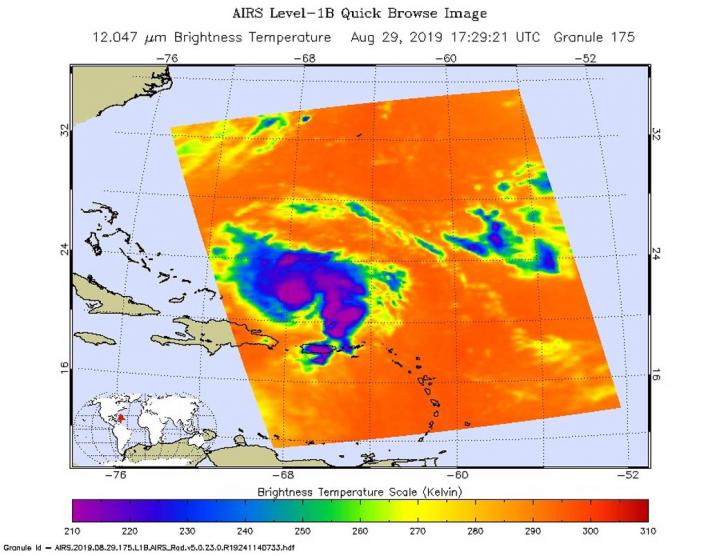
The National Hurricane Center (NHC) in Miami reports that an Air Force plane is finding Dorian a “little stronger” as of the 8:00am EDT advisory put out today, Aug. 30, 2019. Data from an Air Force Reserve reconnaissance aircraft indicate that…
New study published in Geology
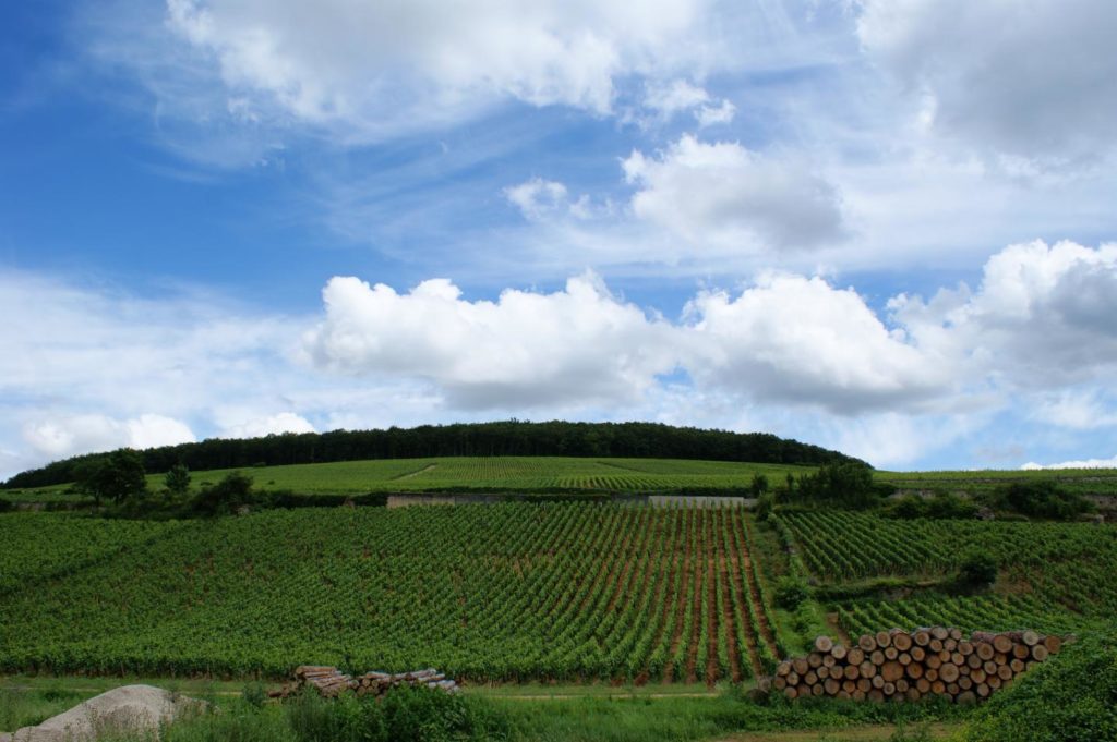
A newly published series of dates of grape harvest covering the past 664 years is the latest line of evidence confirming how unusual the climate of the past 30 years has been. The record shows wine grapes in Burgundy, eastern…
Multinational study shows significant regional differences in severity of floods