Although Hurricane Juliette is no longer a major hurricane in the Eastern Pacific Ocean, NASA’s Aqua satellite revealed there are still powerful thunderstorms around its center and captured an image of the storm over Socorro Island, Mexico.
Aqua provided forecasters at the National Hurricane Center with infrared data and cloud top temperature information that indicate Juliette’s rainmaking capabilities that affected Socorro Island.
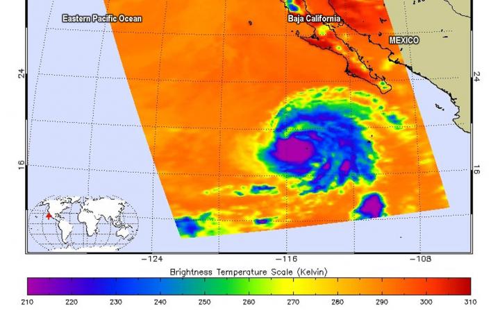
Cloud top temperatures provide information to forecasters about where the strongest storms are located within a tropical cyclone. The stronger the storms, the higher they extend into the troposphere with colder cloud temperatures.
NASA’s Aqua satellite analyzed the storm on Sept. 3, at 5:05 p.m. EDT (2105 UTC) using the Atmospheric Infrared Sounder or AIRS instrument. AIRS found coldest cloud top temperatures as cold as or colder than minus 63 degrees Fahrenheit (minus 53 degrees Celsius) around the center and in fragmented bands of thunderstorms stretching from the north to the southeast. NASA research has shown that cloud top temperatures that cold indicate strong storms that have the capability to create heavy rain. That heavy rainfall was experienced by the small number of residents on Socorro Island.
Socorro Island is a small volcanic island in the Revillagigedo Islands. It is about 373 miles (600 km) west of Mexico’s west coast. The island is only 51 square miles or 132 square kilometers. It is the largest of the four islands of the Revillagigedo Archipelago.
On Sept. 3, NOAA’s National Hurricane Center’s (NHC) noted at 5 a.m. EDT (0900 UTC), the center of Hurricane Juliette was located near latitude 19.1 degrees north and, longitude 116.4 degrees west. The center is about 495 miles (795 km) west-southwest of the southern tip of Baja California, Mexico. Juliette is moving toward the west-northwest near 6 mph (9 kph), and this general motion is expected during the next few days. Maximum sustained winds are near 110 mph (175 kph) with higher gusts. The estimated minimum central pressure is 966 millibars.
NHC said that additional slow weakening is forecast during the next several days.
For updated forecasts, visit:
http://www.
nhc.
noaa.
gov
For updated warnings from the Mexican Meteorological Service, visit:
https:/
/
smn.
conagua.
gob.
mx/
es/
pronosticos/
avisos/
aviso-de-ciclon-tropical-en-el-oceano-pacifico
###
This part of information is sourced from https://www.eurekalert.org/pub_releases/2019-09/nsfc-nch090419.php
Rob Gutro
[email protected]
http://www.nasa.gov/goddard

