Laminarin plays central role in marine carbon cycle; in the sunlit surface layer of the ocean, photosynthetic microalgae convert much carbon dioxide into biomass; scientists from Bremen and Bremerhaven now quantified details of this process
Tag: Climate Science
NASA analyzes tropical cyclone Herold’s water vapor concentration
When NASA’s Aqua satellite passed over the Southern Indian Ocean on Mar. 18, it gathered water vapor data that showed wind shear was adversely affecting Tropical Cyclone Herold. In general, wind shear is a measure of how the speed and…
Global warming influence on extreme weather events has been frequently underestimated
A new Stanford study reveals that a common scientific approach of predicting the likelihood of future extreme weather events by analyzing how frequently they occurred in the past can lead to significant underestimates – with potentially significant consequences for people’s…
$8.3M award to WHOI extends observational record of critical climate research
The National Science Foundation (NSF) recently awarded $8.2 million to the Woods Hole Oceanographic Institution (WHOI) to extend the life of the Overturning in the Sub-polar North Atlantic Program (OSNAP) in a key part of Earth’s ocean-climate system. The award…

Natural solutions to the climate crisis? One-quarter is all down to Earth…
Joint research conducted by The Nature Conservancy and the Kunming Institute of Botany, Chinese Academy of Sciences calculated the carbon-storing power of global soils and showcased approaches like agroforestry designed to capitalise on untapped potential.
Plant water saving system works like clockwork, it transpires
Plants, just like humans, have circadian clocks that allow them to tell the time. In humans this cellular clockwork influences when we wake and sleep. Plants are so dependent on daylight that circadian clocks are even more influential, regulating the…
Emissions of several ozone-depleting chemicals are larger than expected
Recovering and safely destroying the sources of these chemicals could speed ozone recovery and reduce climate change
Tropical Cyclone Herold’s eye opens further on NASA satellite imagery
As Tropical Cyclone Herold intensified, its eye appeared more defined in imagery taken by NASA’s Terra satellite. A Tropical Cyclone Warning class 3 was in force for Rodrigues Island on March 17. Rodrigues is an autonomous outer island of the…
NASA finds Gretel becoming extra-tropical
NASA’s Terra satellite passed over the Southern Pacific Ocean and captured an image of Tropical Storm Gretel as it was transitioning into an extra-tropical cyclone, northwest of New Zealand. Tropical Cyclone 23P formed on March 14 at 4 p.m. EDT…
NASA sees Tropical Cyclone Herold’s eye
NASA’s Aqua satellite passed over the Southern Indian Ocean and captured an image of a well-developed Tropical Cyclone Herold at hurricane strength, east of Madagascar. Herold formed on March 13 as Tropical Cyclone 22S and once it intensified into a…
New research first to relate Antarctic sea ice melt to weather change in tropics
Diminishing sea ice translates to warmer ocean, more rain, and stronger trade winds
Regional nuclear war a risk for global food security
Even a limited nuclear war could have dangerous effects far beyond the region that is fatally hit. It would result in global cooling that substantially reduces agricultural production in the world’s main breadbasket regions, from the US, to Europe, Russia,…

What causes an ice age to end?
New University of Melbourne research has revealed that ice ages over the last million years ended when the tilt angle of the Earth’s axis was approaching high values.
First-time direct proof of chemical reactions in particulates
Researchers at the Paul Scherrer Institute PSI have developed a new method to analyse particulate matter more precisely than ever before. With its help, they disproved an established doctrine: that molecules in aerosols undergo no further chemical transformations because they…
How plants sound the alarm about danger
Team led by Salk scientists provides a detailed picture of how plant hormones communicate through gene regulation
NASA’s Terra Satellite observes development of Tropical Storm 22S
NASA’s Terra satellite passed over the Southern Indian Ocean and provided forecasters with a visible image of newly formed Tropical Storm 22S, located near northeastern Madagascar. The Moderate Resolution Imaging Spectroradiometer or MODIS instrument aboard Terra provided a visible image…
NASA finds ex-Tropical Cyclone 21S affecting Australia’s Pilbara Coast
NASA’s Terra satellite passed over the Southern Indian Ocean and provided forecasters with a visible image of Ex-Tropical Cyclone 21S. Although no longer a tropical cyclone, the system has triggered warnings for heavy rainfall and winds. Tropical cyclone 21S was…
Coral reefs ‘weathering’ the pressure of globalization
Research links ENSO climate pattern to Southeast Asian coral reefs
NASA-NOAA satellite catches development of tropical storm 21S
NASA-NOAA’s Suomi NPP satellite passed over the Southern Indian Ocean and provided forecasters with a visible image of newly formed Tropical Storm 21S. The Visible Infrared Imaging Radiometer Suite (VIIRS) instrument aboard Suomi NPP provided a visible image of Tropical…
Biomass Fuels can Significantly Mitigate Global Warming — Ben-Gurion U.
Biomass Fuels as a Gasoline Replacement can Significantly Mitigate Global Warming, According to New Study by Ben-Gurion University BEER-SHEVA, ISRAEL…March 10, 2020 – Biomass fuels derived from various grasses could significantly mitigate global warming by reducing carbon, according to a…
Climate shifts prompt shrubs and trees to take root in open areas
Wild, treeless landscapes are becoming more wooded as climate change leads to warming temperatures and wetter weather, research suggests. Trees and shrubs are spreading across the tundra and the savanna, transforming these vast, open areas that contain unique biodiversity, researchers…
Rain, more than wind, led to massive toppling of trees in Hurricane Maria, says study
Surprising conclusion signals a hidden threat to forests in future hurricanes
Rain, more than wind, led to massive toppling of trees in Hurricane Maria, says study
Surprising conclusion signals a hidden threat to forests in future hurricanes
UNIST and JDC sign MoU for research collaboration
The signing ceremony of MoU between UNIST and Jeju Free International City Development Center took place on January 15, 2020.
Indian Ocean phenomenon spells climate trouble for Australia
New international research has found a worrying change in the Indian Ocean’s surface temperatures that puts southeast Australia on course for increasingly hot and dry conditions. The work led by The Australian National University (ANU) and the ARC Centre of…
Damaging impacts of warming moderated by migration of rainfed crops
Continued migration, however, may result in significant environmental costs
Tropical fire soot deposited in the ocean will help predict future global climate changes
Studying the processes of transport of smoke from the fires of tropical Africa and the dust of the Sahara Desert, and its deposition in marine sediments to understand how atmospheric circulation has shifted in the past, and to be able…
Fire from the sky
Researchers find evidence of a cosmic impact that caused destruction of one of the world’s earliest human settlements
Deep-sea fish community structure strongly affected by oxygen and temperature
Research on deep-sea fish density and diversity in the Gulf of California has implications for climate change
Satellite data boosts understanding of climate change’s effects on kelp
CORVALLIS, Ore. – Tapping into 35 years of satellite imagery, researchers at Oregon State University have dramatically enlarged the database regarding how climate change is affecting kelps, near-shore seaweeds that provide food and shelter for fish and protect coastlines from…
NASA tracks ex-Tropical Cyclone Esther over Northern Territory
NASA’s Aqua satellite continues to provide forecasters with a visible image ex-tropical cyclone Esther’s remnant clouds and storms, now over the Barkly Region of Australia’s Northern Territory. On March 4, the Moderate Resolution Imaging Spectroradiometer or MODIS instrument that flies…
Sensitivity to low flow
Heat, dry conditions, and the resulting low flows in rivers and lakes characterized the summer months of 2003, 2015 and 2018 in Europe. Another low flow period is on the cards for the summer of 2020. Researchers from the University…
New book tells of early Antarctic explorations, continent’s connection to climate
A new book illustrates the environmental history of Antarctica through stories of 19th-century expeditions.
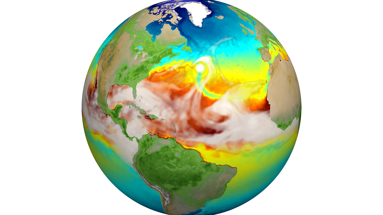
New version of Earth model captures detailed climate dynamics
DOE laboratories are collaborating on a new high-resolution Earth systems model to predict climate trends into the next century. The model will provide the scientific basis by which to mitigate the effects of extreme climate on energy and other essential services.
More than 60% of Myanmar’s mangroves has been deforested in the last 20 years: NUS study
Between 1996 and 2016, substantial mangrove forests have been converted to agricultural use; Pressing need to protect the critical coastal ecosystem
NASA sees ex-tropical cyclone Esther move back into northern territory
NASA-NOAA’s Suomi NPP satellite provided forecasters with a visible image ex-tropical cyclone Esther’s remnant clouds that have now moved over Australia’s Northern Territory. The remnants have generated a flood watch including in the Tanami and Central Deserts. Visible imagery from…
Texas A&M researchers develop flooding prediction tool
Almost real-time flood prediction tool may boost emergency response during hurricanes
Coral reefs in Turks and Caicos Islands resist global bleaching event
CHAMPAIGN, Ill. — A study that relied on citizen scientists to monitor the health of corals on Turks and Caicos Islands in the Caribbean from 2012 to 2018 found that 35 key coral species remained resilient during a 2014-17 global…
New model shows winners, losers among marine microbes in warming oceans
A USC-led research team developed a new tool to show how rising ocean temperatures help and hurt various marine microbes
Ocean changes almost starved life of oxygen
Chemical changes in the oceans more than 800 million years ago almost destroyed the oxygen-rich atmosphere that paved the way for complex life on Earth, new research suggests. Then, as now, the planet had an “oxidizing” atmosphere, driven by phytoplankton…
Collaborative using UVM researcher using NSF grant to recreate regional temperature data
Discovering a missing piece of recent climate data
Collaborative using UVM researcher using NSF grant to recreate regional temperature data
Discovering a missing piece of recent climate data
NASA finds ex-Tropical Cyclone Esther moving back inland
Ex-Tropical Cyclone Esther just won’t give up. The storm formed in the South Pacific Ocean, tracked across Australia’s Northern Territory and reached the Kimberley coast of Western Australia, and has now turned around. NASA’s Aqua satellite provided forecasters with a…
Ocean changes almost starved life of oxygen
Chemical changes in the oceans more than 800 million years ago almost destroyed the oxygen-rich atmosphere that paved the way for complex life on Earth, new research suggests. Then, as now, the planet had an “oxidizing” atmosphere, driven by phytoplankton…