NASA’s CloudSat passed over Tropical Storm Isaias as it was strengthening back into a hurricane on Aug. 3, and before it made landfall in North Carolina. CloudSat revealed areas of heavy rain and ice particles in high, powerful clouds. Tropical Storm…
Tag: TEMPERATURE-DEPENDENT PHENOMENA
NASA infrared imagery shows Hagupit nearing landfall in China
NASA’s Aqua satellite provided a look at Typhoon Hagupit as it was nearing landfall in southeastern China. One of the ways NASA researches tropical cyclones is using infrared data that provides temperature information. Cloud top temperatures provide information to forecasters…
NASA providing data on Tropical Storm Isaias as it blankets eastern seaboard
Tropical Storm Isaias made landfall late on Aug. 3 and by today, Aug. 4, the huge storm stretched from Virginia to Maine. NASA satellites have been providing forecasters with rainfall rates, cloud top temperatures, storm extent and strength as Isaias…
Atmospheric and earth system research with special halo aircraft to continue
DFG extends funding by another six years
COVID-19: Lower incidence at high altitudes?
New Rochelle, NY, August 3, 2020–Despite recent reports of lower COVID-19 incidence among high-altitude populations, current data is insufficient to conclude that high altitude is protective against the SARS-CoV-2 virus, as reported in the peer-reviewed journal High Altitude Medicine &…
NASA finds an eye and a giant ‘tail’ in Typhoon Hagupit
NASA-NOAA’s Suomi NPP satellite provided forecasters with a visible image of Typhoon Hagupit in the Northwestern Pacific Ocean that showed the development of an eye as it quickly intensified. Imagery also showed a thick band of thunderstorms that resembled a…
NASA puts visible and water vapor eyes on Tropical Storm Isaias
NASA’s Aqua satellite obtained visible and water vapor imagery as Tropical Storm Isaias continued moving along the east coast of Florida. On Aug. 3, Warnings and Watches stretched from Florida to Maine. NASA Satellite View: Isaiah’s Organization The Moderate Resolution…
NASA satellites show two views of California’s Apple Fire
NASA’s satellites were working overtime as they snapped pictures of the large Apple Fire in Banning Canyon near San Bernardino, California on Aug. 02, 2020. This fire began on July 31, 2020 and the cause of the fire is still…
North Atlantic climate far more predictable following major scientific breakthrough
A team of scientists, led by UK Met Office, has achieved a scientific breakthrough allowing the longer-term prediction of North Atlantic pressure patterns, the key driving force behind winter weather in Europe and eastern North America. CMCC scientists Panos Athanasiadis…
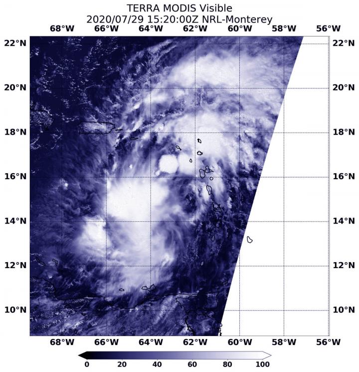
NASA follows potential tropical cyclone 9 into eastern Caribbean
NASA’s Terra satellite obtained visible imagery of Potential Tropical Cyclone 9 after it moved into the Eastern Caribbean Sea and continued bringing heavy rainfall and gusty winds to the Leeward Islands, the U.S. and British Virgin Islands and Puerto Rico.

Report provides new framework for understanding climate risks, impacts to US agriculture
Agricultural production is highly sensitive to weather and climate, which affect when farmers and land managers plant seeds or harvest crops. These conditions also factor into decision-making, when people decide to make capital investments or plant trees in an agroforestry system.
An international study analyzes five hundred years of floods in Europe
The research has been published in Nature
NASA examines Tropical Storm Gonzalo’s structural changes
Visible and microwave imagery from NASA’s Aqua satellite indicated Tropical Storm Gonzalo was slightly less organized than it was on the previous day. Gonzalo formed in the central North Atlantic Ocean on July 21 and is moving west. The Moderate…
NASA finds strength in new Gulf Tropical Depression 8
NASA’s Aqua satellite used infrared light to identify the strongest storms and coldest cloud top temperatures in Tropical Depression 8, spinning in the Gulf of Mexico. Tropical Depression 8 formed in the Gulf about 530 miles (855 km) east-southeast of…
NASA sees compact Douglas strengthening to a major hurricane
Although a compact storm, hurricane Douglas in the Eastern Pacific is mighty, as it has become the season’s first major hurricane. NASA-NOAA’s Suomi NPP satellite provided forecasters with an image of Douglas that showed development of an eye as it…

International analysis narrows range of climate’s sensitivity to CO2
The most advanced and comprehensive analysis of climate sensitivity yet undertaken has revealed with more confidence than ever before how sensitive the Earth’s climate is to carbon dioxide.
International analysis narrows range of climate’s sensitivity to CO2
Four years of research confidently narrows range of 1.5°C-4.5°C down to 2.3°C-3.9°C
2,000 years of storms in the Caribbean
Geoscientists from Goethe University create sedimentary archive with annual resolution
Climate predictions several years into the future?
A study from Kiel reveals potential and mechanisms
NASA infrared confirms Douglas still a tropical storm
Infrared data from NASA’s Terra satellite showed that dry air around Tropical Storm Douglas has been inhibiting it from strengthening into a hurricane. On July 22 at 2:15 a.m. EDT (0615 UTC), the Moderate Resolution Imaging Spectroradiometer or MODIS instrument…
NASA sees record-breaking new Tropical Storm Gonzalo strengthening
The seventh named tropical cyclone of the North Atlantic Ocean has formed, and like some others this season, it has broken a record. NASA’s Aqua satellite provided a look at the small record-breaker. The National Hurricane Center (NHC) reports that…
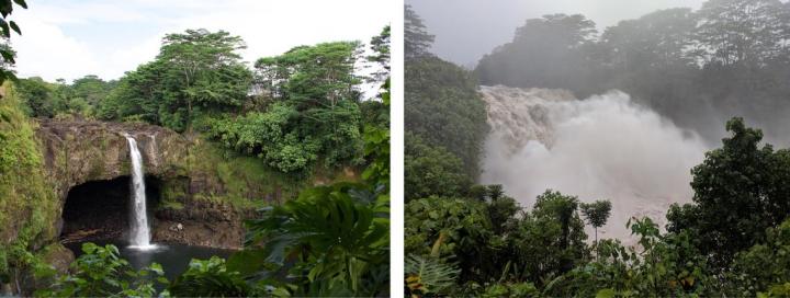
New research reveals how hurricane Lane brought fire and rain to Hawaiian islands
Hurricane Lane was an impactful event for the Hawaiian Islands.
NASA finds wind shear and cooler waters winding down Tropical Depression 7E
NASA-NOAA’s Suomi NPP satellite passed over the Eastern Pacific Ocean and provided forecasters with a visible image of the waning Tropical Depression 7E. Wind shear and cooler waters were taking their toll on the storm. The Visible Infrared Imaging Radiometer…
Tropical Storm Douglas organizing in NASA infrared imagery
Tropical Depression 8E developed on July 20 and quickly organized into a tropical storm. Infrared NASA satellite imagery revealed that Tropical Storm Douglas contained strong storms and showed banding of thunderstorms around its center. Tropical Depression 8E formed about 905…
Global warming boosts heat-related cardiovascular hospitalizations, study finds
The impact of high temperatures on hospitalizations due to cardiovascular diseases has increased over the past two decades in Queensland, Australia, according to a new study published this week in PLOS Medicine by Shanshan Li and Yuming Guo of Monash…
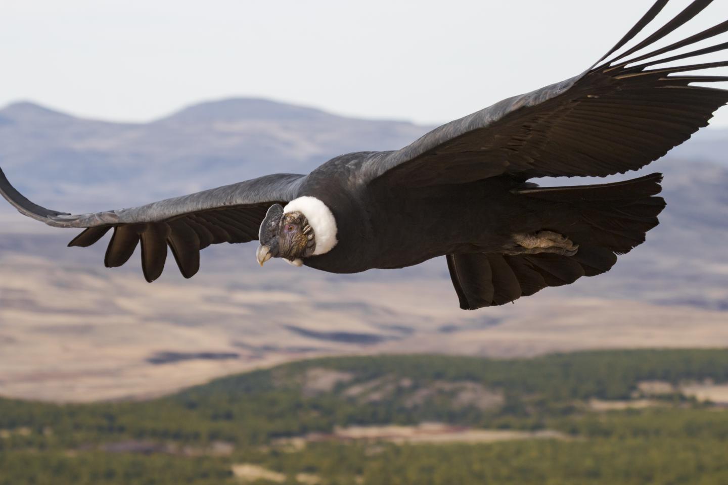
Experts’ high-flying study reveals secrets of soaring birds
New research has revealed when it comes to flying the largest of birds don’t rely on flapping to move around. Instead they make use of air currents to keep them airborne for hours at a time.
Neanderthals of Western Mediterranean did not become extinct because of changes in climate
Homo Neanderthaliensis did not become extinct because of changes in climate. At least, this did not happen to the several Neanderthals groups that lived in the western Mediterranean 42,000 years ago. A research group of the University of Bologna came…
NASA analyzes new eastern Pacific Ocean Tropical Depression 7E
The seventh tropical depression of the Eastern Pacific Ocean has formed. NASA’s Terra satellite used infrared light to identify the area of strongest storms and coldest cloud top temperatures in Tropical Depression 7E. Tropical Depression 7E formed in the Eastern…
New research reveals how hurricane Lane brought fire and rain to Hawaiian islands
Hurricane Lane was an impactful event for the Hawaiian Islands. In August 2018, over a four-day period, the island of Hawai’i received an average of 17 inches of rainfall, with a four-day single-station maximum of 57 inches, making Hurricane Lane…
Baleen whales have changed their distribution in the Western North Atlantic
Researchers have been using passive acoustic recordings of whale calls to track their movements.

Social media inspired models show winter warming hits fish stocks
Mathematical modelling inspired by social media is identifying the significant impacts of warming seas on the world’s fisheries.
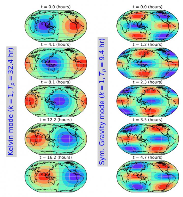
New study detects ringing of the global atmosphere
A ringing bell vibrates simultaneously at a low-pitched fundamental tone and at many higher-pitched overtones, producing a pleasant musical sound.
Tree rings show unprecedented rise in extreme weather in South America
Scientists have filled a gaping hole in the world’s climate records by reconstructing 600 years of soil-moisture swings across southern and central South America.
In the Arctic, spring snowmelt triggers fresh CO2 production
Studies have shown the Arctic is warming roughly twice as fast as the rest of the world, and its soil holds twice the amount of carbon dioxide as the atmosphere. New research from San Diego State University finds that water from spring snowmelt infiltrates the soil and triggers fresh carbon dioxide production at higher rates than previously assumed.
NASA-NOAA satellite animation shows the end of Tropical Cyclone Boris
NASA-NOAA’s Suomi NPP satellite imagery provided a look at the end of the second named tropical cyclone of the Eastern Pacific Ocean’s 2020 Hurricane Season. Tropical Cyclone Boris formed in the Eastern Pacific Ocean on Wednesday, June 24 and by…
NASA-NOAA’s Suomi NPP satellite sees Tropical Storm Boris form
NASA-NOAA’s Suomi NPP satellite provided forecasters with visible image of the Eastern Pacific Ocean’s second tropical storm of the season, Boris. Boris formed just east of the Central Pacific Ocean’s boundary as it was moving into that region. The Central…
Agricultural fires in central Africa light up in Suomi NPP satellite image
Fires have spread across the majority of the landscape in Angola and the Democratic Republic of the Congo in this NOAA/NASA Suomi NPP satellite image using the VIIRS (Visible Infrared Imaging Radiometer Suite) instrument from June 25, 2020. Fires of…
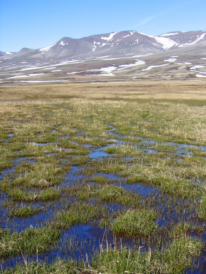
Spider baby boom in a warmer Arctic
Climate change leads to longer growing seasons in the Arctic. A new study, which has just been published in Proceedings of the Royal Society B, show that predators like wolf spiders respond to the changing conditions and have been able to produce two clutches of offspring during the short Arctic summer.
NASA finds post-Tropical Cyclone Dolly exiting the tropical stage
NASA’s Terra satellite provided a night-time look at what is now Post-Tropical Storm Dolly in the Northern Atlantic Ocean. Terra found that all of Dolly’s clouds were on one side of the storm as the storm weakened further. The National…
New research will look at heat wave risks during pandemic
Scientists to study intersecting impacts of extreme heat and COVID-19
Better prepared for forest fires
Cross-institute project to understand the dynamics of forest fires and mitigate the risk
NASA analyzes the newest Atlantic Ocean subtropical depression
NASA’s Aqua satellite used infrared light to analyze the strength of storms in the North Atlantic Ocean’s newly formed Subtropical Depression 4. Infrared data provides temperature information to find the strongest thunderstorms that reach high into the atmosphere which have…
NASA satellite gives a hello to tropical storm Dolly
During the morning of June 23, the fourth system in the Northern Atlantic Ocean was a subtropical depression. By the afternoon, the subtropical depression took on tropical characteristics and was renamed Dolly. NASA’s Terra satellite greeted Tropical Storm Dolly by…
NOAA/NASA’s Suomi NPP satellite captures 63 mile smoke trail from bush fire
NOAA/NASA’s Suomi NPP satellite captured this image of the Bush Fire on June 22, 2020 showing clouds of smoke pouring off the Bush Fire that is plaguing Arizona. Overnight (to the 23rd) the fire grew to 186,848 acres, growing 2,200…
New research will look at heat wave risks during pandemic
Scientists to study intersecting impacts of extreme heat and COVID-19