New research shed lights on the complex relationships between tree types, forest soil nutrients and microbes, and impact on environment
Tag: ATMOSPHERIC CHEMISTRY
More than just CO2: It’s time to tackle short-lived climate-forcing pollutants
Climate change mitigation is about more than just CO2. So-called “short-lived climate-forcing pollutants” such as soot, methane, and tropospheric ozone all have harmful effects. Climate policy should be guided by a clearer understanding of their differentiated impacts. It is common…
New NCAR-Wyoming supercomputer to accelerate scientific discovery
New system will advance nation’s understanding of geosciences
How aerosols are formed
Aerosols are suspensions of fine solid particles or liquid droplets in a gas. Clouds, for example, are aerosols because they consist of water droplets dispersed in the air. Such droplets are produced in a two-step process: first, a condensation nucleus…
Semper floats! Marines use sensor buoys to better understand ocean battlespace
ARLINGTON, Va.–Flying several thousand feet above the Pacific Ocean, an air crew and a scientist from Woods Hole Oceanographic Institution tossed cylindrical floats from a U.S. Marine Corps MV-22 Osprey aircraft. Packed with data-gathering sensors to measure underwater conditions, the…
The upside of volatile space weather
Robust stellar flares might not prevent life on exoplanets, could facilitate its detection
Land ecosystems are becoming less efficient at absorbing CO2
Land ecosystems currently play a key role in mitigating climate change. The more carbon dioxide (CO2) plants and trees absorb during photosynthesis, the process they use to make food, the less CO2 remains trapped in the atmosphere where it can…
Potentially damaging surface ozone levels rose in lockdown
Less traffic in first lockdown reduced air pollution but caused potentially damaging surface ozone levels to rise
Mystery solved: new study shows link between hot and dry weather and air quality in Korea
Scientists demonstrate ground-level ozone concentrations have risen alongside the increasingly frequent spells of dry tropical weather
Shedding light on the dark side of biomass burning pollution
Oxidized aerosol from biomass burning is especially toxic; a new study identifies new nocturnal processes in the forming of these aerosols and suggests their levels are largely underestimated
Better benzene sensing at laser point
A laser-based sensor developed at KAUST could improve monitoring of benzene emissions and limit exposure to this pollutant. In collaboration with Saudi Aramco, KAUST researchers have developed a device that accurately senses extremely low concentrations of benzene in real time.…
The natural ‘Himalayan aerosol factory’ can affect climate
Large amounts of new particles can form in the valleys of the Himalayas from naturally emitted gases and can be transported to high altitudes by the mountain winds and injected into the upper atmosphere. The emitted particles may eventually affect…
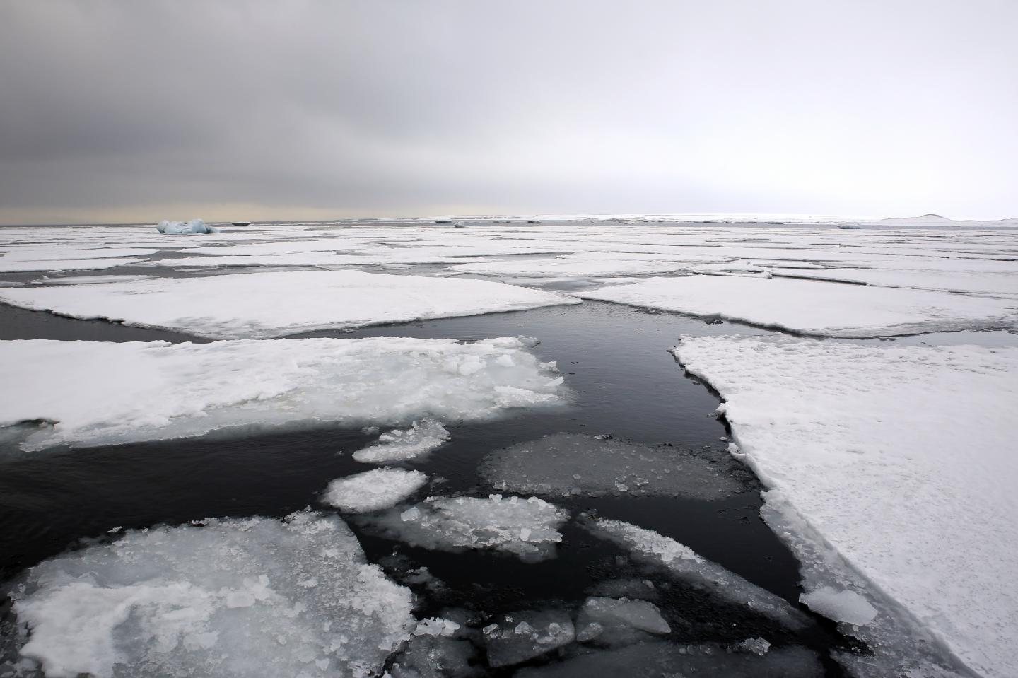
The climate changed rapidly alongside sea ice decline in the north
Researchers from the Niels Bohr Institute, University of Copenhagen have, in collaboration with Norwegian researchers in the ERC Synergy project, ICE2ICE, shown that abrupt climate change occurred as a result of widespread decrease of sea ice.
Ozone breaks down THC deposited on surfaces from thirdhand cannabis smoke
Second- and thirdhand tobacco smoke have received lots of attention, but much less is known about the compounds deposited on surfaces from cannabis smoke. Now, researchers reporting in ACS’ Environmental Science & Technology have discovered that ozone –a component of…
Bleach-alternative COVID-19 surface disinfectants may pollute indoor air: USask research
Cleaning surfaces with hydrogen peroxide-based disinfectants has the potential to pollute the air and pose a health risk, according to research led by University of Saskatchewan (USask). The research team found that mopping a floor with a commercially available hydrogen…
Oil & gas industry commits to new framework to monitor, report and reduce methane emissions
Governments, UN, civil society, companies collaborate on robust new tracking and disclosure system
CCNY researchers overcome barriers for bio-inspired solar energy harvesting materials
Inspired by nature, researchers at The City College of New York (CCNY) can demonstrate a synthetic strategy to stabilize bio-inspired solar energy harvesting materials. Their findings, published in the latest issue of Nature Chemistry , could be a significant breakthrough…
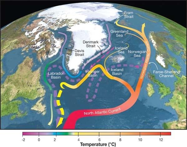
Reducing aerosol pollution without cutting carbon dioxide could make the planet hotter
Humans must reduce carbon dioxide and aerosol pollution simultaneously to avoid weakening the ocean’s ability to keep the planet cool, new research shows.
Reducing aerosol pollution without cutting carbon dioxide could make the planet hotter
Solving one environmental problem could create another
Preparing for a human mission to Mars
New Rochelle, NY, November 12, 2020–Future human missions to Mars depend on field research in an environment similar to that of Mars. It will enable the evaluation of operational concepts and optimization of strategies. The goals and results of the…
How air pollution affects homeless populations
When air quality worsens, either from the smoke and ozone of summer or the inversion of winter, most of us stay indoors. But for individuals experiencing homelessness, that’s not always an option. In a new study, researchers from the University…
Tree rings may hold clues to impacts of distant supernovas on Earth
Massive explosions of energy happening thousands of light-years from Earth may have left traces in our planet’s biology and geology, according to new research by University of Colorado Boulder geoscientist Robert Brakenridge. The study, published this month in the International…
Decrease in fossil-fuel CO2 emissions due to COVID-19 detected by atmospheric observations
Synoptic CO2 variations decreased at Hateruma Island, Japan, during February-March 2020
Brown carbon ‘tarballs’ detected in Himalayan atmosphere
Some people refer to the Himalaya-Tibetan Plateau as the “third pole” because the region has the largest reserve of glacial snow and ice outside of the north and south poles. The glaciers, which are extremely sensitive to climate change and…
International team tracks record-setting smoke cloud from Australian wildfires
SASKATOON – Researchers with the University of Saskatchewan’s Institute of Space and Atmospheric Studies are part of a global team that has found that the smoke cloud pushed into the stratosphere by last winter’s Australian wildfires was three times larger…
How a greenhouse catastrophe killed nearly all life
Scientists show the unfolding of one of the largest mass extinctions in Earth’s history
NASA finds wind shear affecting Tropical Storm Nangka post-landfall
Tropical Storm Nangka made landfall south of Haiphong, Vietnam and began to weaken. NASA’s Aqua satellite revealed wind shear was affecting the storm as it continued to push inland. The Moderate Resolution Imaging Spectroradiometer or MODIS instrument that flies aboard…
Thawing permafrost releases organic compounds into the air
When permafrost thaws due to global warming, not only the greenhouse gases known to all, but also organic compounds are released from the soil.
Aerosols vs droplets
Winter is on its way. And in this year of coronavirus, with it comes the potential for a second wave of COVID-19. Add in flu season and our tendency to head inside and close our windows to the cold, wet weather, and it appears the next several months are going to present us with new health challenges.
NASA rainfall imagery reveals Norbert regains tropical storm status
Norbert has been meandering around in the Eastern Pacific Ocean for several days as a tropical depression. A NASA satellite rainfall product that incorporates data from satellites and observations revealed that Norbert has regained tropical storm status after showing increased…
Recent Atlantic ocean warming unprecedented in nearly 3,000 years
UMass Amherst, Canadian research uses ancient lake sediments to extend climate record
NASA animation tracks the end of Tropical Storm Delta
NASA’s Terra satellite obtained visible imagery as Tropical Storm Delta made landfall in Louisiana and moved northeastward soaking the U.S. southeast and Mid-Atlantic states. NASA Satellite View: Delta’s Organization The Moderate Resolution Imaging Spectroradiometer or MODIS instrument that flies aboard…
NASA sees Tropical Storm Nangka soaking Hainan Island
Using a NASA satellite rainfall product that incorporates data from satellites and observations, NASA estimated Nangka’s rainfall rates as the storm soaked Hainan Island, China early on Oct. 13 (EDT). Nangka formed in the South China Sea and moved in…
New global temperature data will inform study of climate impacts on health, agriculture
A seemingly small one-to-two degree change in the global climate can dramatically alter weather-related hazards. Given that such a small change can result in such big impacts, it is important to have the most accurate information possible when studying the…
School absences correlate to impaired air quality
Even mildly elevated air pollution associated with increase in absences in Salt Lake City
NASA shows heaviest rainfall displaced in Typhoon Chan-hom
Typhoon Chan-hom was still moving parallel to Japan’s east coast as NASA’s satellite rainfall product, that incorporates data from satellites and observations, showed its heaviest rainfall was pushed northeast of center. Chan-hom’s Status on Oct. 9 At 5 a.m. EDT…
NASA finds hurricane delta packing heavy rainfall
NASA’s satellite rainfall product that incorporates data from satellites and observations found that Hurricane Delta was bringing along heavy rainfall as it headed to the U.S. Gulf Coast on Oct. 9. Warnings and Watches in Effect on Oct. 9 There…
NASA examines Hurricane Delta’s early morning structure
The NASA-NOAA Suomi NPP satellite provided two nighttime views of Hurricane Delta as it moved toward the U.S. Gulf Coast. A moonlit image and an infrared image revealed the extent and organization of the intensifying hurricane. Satellite Imagery Shows Delta’s…
N2O emissions pose an increasing climate threat, finds breakthrough study
Rising nitrous oxide (N2O) emissions are jeopardizing the climate goals of the Paris Agreement, according to a major new study by an international team of scientists.
NASA analyzes Hurricane Delta’s water vapor concentration
When NASA’s Aqua satellite passed over the Caribbean Sea on Oct. 7, it gathered water vapor data on Hurricane Delta as Mexico’s Yucatan continues to feel its effects. Water vapor analysis of tropical cyclones tells forecasters how much potential a…
NASA analyzes rainfall around Typhoon Chan-hom’s ragged eye
A NASA satellite rainfall product that incorporates data from satellites and observations found heavy rainfall occurring throughout Typhoon Chan-hom and the heaviest rainfall in the eyewall. Chan-hom is expected to bring rainfall to Japan on its track through the Northwestern…
NASA finds dry air sapping Tropical Storm Norbert’s strength
Infrared imagery from NASA’s Aqua satellite revealed that dry air is eroding Tropical Storm Norbert, located off the coast of southwestern Mexico. Infrared Data Reveals Dry Air Effects On Oct. 7 at 4:30 a.m. EDT (0830 UTC), the Moderate Resolution…
Revising climate models with new aerosol field data
Smoke from the many wildfires burning in the West have made air quality hazardous for millions of people in the United States. And it is the very tiniest of the aerosol particles in that air that make it particularly harmful…
California’s August Complex largest fire in state’s history
NOAA/NASA’s Suomi NPP satellite captured another startling image of the August Complex of fires that has grown to over 1,000,000 acres burned (1,006,140 acres total) and because of that grim milestone the complex has been dubbed a “gigafire.” The August…
Infrared NASA imagery finds Chan-hom organizing, consolidating
NASA’s Aqua satellite analyzed the large Tropical Storm Chan-hom as it tracked through the Northwestern Pacific Ocean. Aqua imagery showed the storm was consolidating, indicating a strengthening trend. One of the ways NASA researches tropical cyclones is using infrared data…
NASA catches development of Tropical Storm Norbert as Marie declines
NASA-NOAA’s Suomi NPP satellite passed over the Eastern Pacific Ocean and captured the birth of a depression that became Tropical Storm Norbert while Marie continued weakening while headed toward the Central Pacific. Tropical Depression 19E formed well offshore of southwestern…
NASA-NOAA satellite finds Hurricane Delta rapidly intensifying
Infrared imagery from NASA-NOAA’s Suomi NPP satellite revealed that Hurricane Delta has been rapidly growing stronger and more powerful. Infrared imagery revealed that powerful thunderstorms circled the eye of the hurricane and southern quadrant as it moved through the Caribbean…
NASA infrared imagery reveals wind shear displacing Marie’s strongest storms
NASA’s Aqua satellite provided an infrared view of Tropical Storm Marie that revealed the effects of outside winds battering the storm. Wind shear occurs when winds at different levels of the atmosphere push against the rotating cylinder of winds, weakening…
NASA imagery reveals Tropical Storm Chan-hom’s skewed structure
NASA’s Terra satellite obtained visible imagery of Tropical Storm Chan-hom as it continued moving though the Northwestern Pacific Ocean. The imagery revealed that the center of circulation was exposed and its strongest storms were south of the center. Tropical Depression…
NASA imagery reveals Tropical Storm Gamma battered by wind shear
NASA’s Terra satellite obtained visible imagery of Tropical Storm Gamma being battered by outside winds in the south central Gulf of Mexico. Over the weekend of Oct. 3 and 4, Gamma tracked over Mexico’s Yucatan Peninsula. Tropical Depression 25 formed…