Formerly a typhoon, now an extra-tropical storm, Neoguri has taken on more of a frontal system appearance in imagery from NASA’s Aqua satellite. The final warning on the system has been issued. On Oct. 22, the Moderate Imaging Spectroradiometer or…
Tag: WEATHER/STORMS
NASA catches short-lived Tropical Storm Priscilla’s landfall in Mexico
Tropical Storm Priscilla was short-lived because it formed on Sunday, Oct. 20 very close to the coast of western Mexico and made landfall that same day. NASA’s Terra satellite provided a visible picture of the storm as it was making…
NASA finds a transitioning Tropical Storm Neoguri
NASA’s Terra satellite passed over the Northwestern Pacific Ocean on Oct. 21 and captured a visible image of Tropical Storm Neoguri. Satellite imagery revealed that the storm is becoming extra-tropical. On Oct. 21, the Moderate Imaging Spectroradiometer or MODIS instrument…
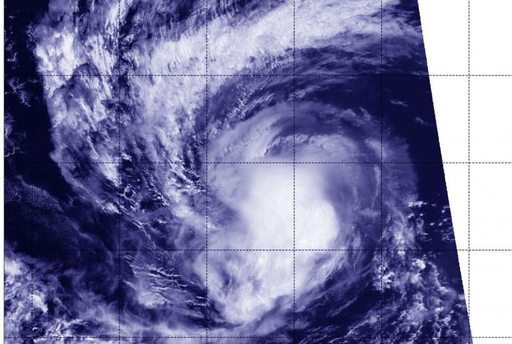
NASA finds Typhoon Bualoi rapidly intensified
Typhoon Bualoi rapidly intensified over 24 hours and quickly developed an eye and powerful thunderstorms. On Oct. 21, the eye of Typhoon Bualoi was just over 50 miles from the island of Saipan when NASA-NOAA’s Suomi NPP satellite passed overhead.…
NASA-NOAA satellite observes development of Tropical Storm Octave
NASA-NOAA’s Suomi NPP satellite provided infrared data that showed the development of Tropical Storm Octave in the Eastern Pacific Ocean. Octave formed on Oct. 17 by 5 p.m. EDT as a tropical depression. At that time, it was located about…
NASA-NOAA satellite finds Tropical Storm Neoguri consolidating
NASA-NOAA’s Suomi NPP satellite provided forecasters at the Joint Typhoon Warning Center with a visible image of Tropical Storm Neoguri that showed it had become more organized over the previous 24 hours. Tropical Depression 21W lacked organization for a couple…
NASA-NOAA satellite finds overshooting tops, gravity waves in Tropical Storm Nestor
NASA-NOAA’s Suomi NPP satellite provided night-time and infrared views of developing Tropical Storm Nestor in the Gulf of Mexico and found over-shooting cloud tops and gravity waves. When the satellite passed over the potential tropical depression early on Oct. 18,…
NASA-NOAA satellite catches last burst before demise of Tropical Depression 17E
NASA-NOAA’s Suomi NPP satellite passed over Mexico and found two small areas of very strong thunderstorms near two different coastlines. One area was in Potential Tropical Cyclone 17E in the Eastern Pacific Ocean and the other was for another system…
NASA’s Terra satellite catches end of Atlantic Tropical Depression 15
Tropical Depression Fifteen or TD15, developed off the west coast of Africa on Oct. 14 by 5 p.m. EDT. The depression never strengthened into a tropical storm before it reached the end of its life. NASA’s Terra satellite provided an…
Urbanisation costs Edinburgh over 11 hectares of green land each year
Much of vegetation loss is due to private gardens being paved over or built on
FSU research: Strong storms generating earthquake-like seismic activity
TALLAHASSEE, Fla. — A Florida State University researcher has uncovered a new geophysical phenomenon where a hurricane or other strong storm can spark seismic events in the nearby ocean as strong as a 3.5 magnitude earthquake. “We’re calling them ‘stormquakes,’”…
NASA’s Aqua satellite reveals flooding in Japan from Typhoon Hagibis
Typhoon Hagibis made landfall in Japan over the weekend of October 12 and 13, bringing damaging winds, rough surf and flooding rains. NASA’s Aqua satellite provided a visible image of the flooding caused by the torrential rainfall. Hagibis made landfall…
NASA provides a farewell infrared view of extra-tropical storm Melissa
NASA’s Suomi NPP satellite passed over North Atlantic Ocean on Oct. 14 and provided forecasters with an infrared view of Tropical Storm Melissa that revealed wind shear was tearing the storm apart as it was becoming extra-tropical. NASA’s Suomi NPP…
NASA’s Terra satellite catches a glimpse of a fleeting Ema
Tropical Storm Ema had a very short life, but NASA’s Terra satellite caught a glimpse of the storm before it dissipated in the Central Pacific Ocean. The newest tropical storm of the Central Pacific Ocean hurricane season formed to the…
Lakes worldwide are experiencing more severe algal blooms
Climate change is likely hampering recovery efforts
Heat waves could increase substantially in size by mid-century, says new study
Our planet has been baking under the sun this summer as temperatures reached the hottest ever recorded and heat waves spread across the globe. While the climate continues to warm, scientists expect the frequency and intensity of heat waves to…
Dust in ice cores leads to new knowledge on the advancement of the ice before the ice age
Ice core research: Researchers from the section Physics of Ice, Climate and Earth (PICE) at the Niels Bohr Institute, University of Copenhagen, have succeeded in making a method to enlighten an otherwise dark period in climate history. Working with the…
NASA finds a transitioning cyclone Mitag filling the sea of Japan
NASA’s Terra satellite passed over the Sea of Japan on Oct. 3 and captured a visible image of Tropical Storm Mitag. Clouds associated with the storm blanketed the Sea of Japan and satellite imagery indicated the storm was becoming extra-tropical.…
NASA sees Post-tropical Cyclone Lorenzo affecting Ireland
NASA’s Terra satellite passed over the eastern North Atlantic Ocean early on Oct. 3 and captured a visible image of Post-tropical Cyclone Lorenzo as it neared Ireland. Lorenzo’s eastern side is already affecting Ireland, and both Ireland and the United…
Managing stormwater and stream restoration projects together
Both stormwater control and stream restoration are proven ways to reduce erosion along water channels. Often, though, each method is managed by a different urban land-management department, measuring different success values. Efforts are rarely coordinated due to funding and other…
NASA satellite shows Typhoon Mitag’s large reach over East China Sea
The bulk of Typhoon Mitag’s clouds and precipitation has been pushed north of its center, extending its reach over the East China Sea. Mitag was centered just off the coast of China’s Zhejiang province when NASA-NOAA’s Suomi NPP satellite passed…
NASA finds Narda’s remnants bringing rain to mexico, headed to southwestern US
The remnant low pressure area that was formerly known as tropical cyclone Narda is still generating rainfall as it moves toward the southwestern U.S. The Global Precipitation Measurement mission or GPM satellite provided a look at the rainfall occurring on…
NASA satellite sees a large Hurricane Lorenzo headed toward Azores
Hurricane Lorenzo was heading toward the Azores Islands when NASA-NOAA’s Suomi NPP satellite provided forecasters with an image of the storm. Satellite imagery revealed the large extent of the storm. Visible imagery from NASA satellites help forecasters understand if a…
NASA finds tropical storm Narda bringing heavy rainfall to western Mexico
NASA’s Aqua satellite captured an image of Tropical Storm Narda along Mexico’s west coast in the Eastern Pacific Ocean. Satellite data revealed the potential for heavy rainfall within Narda, and warnings are in effect for portions of western Mexico. Narda…
NASA finds Typhoon Mitag’s eye east of Taiwan
NASA’s Terra satellite captured an image of Typhoon Mitag’s cloud-filled eye, located east of Taiwan. On Sept. 30, the Moderate Imaging Spectroradiometer or MODIS instrument that flies aboard NASA’s Terra satellite provided a visible image of Mitag. The MODIS image…
NASA-NOAA’s Suomi NPP analyzes record-setting hurricane Lorenzo
Over the weekend of Sept. 28 and 29, Hurricane Lorenzo attained Category 5 strength briefly, becoming the strongest hurricane on record in the eastern-most Atlantic Ocean. Lorenzo has also attained and contributed to some other significant statistics. NASA-NOAA’s Suomi NPP…
NASA data stares into the eye of powerful hurricane Lorenzo
Satellite data has confirmed that Lorenzo is a major hurricane in the eastern North Atlantic Ocean with an impressive structure. NASA’s Terra Satellite provided a visible image of Lorenzo that revealed a clear eye and a solid structure of thunderstorms…
NASA Satellite finds Karen holding onto tropical storm status
NASA’s Terra Satellite provides a variety of data on tropical cyclones including cloud heights and cloud top temperatures. Terra examined those factors in Tropical Storm Karen in the North Atlantic Ocean and data showed Karen holding onto tropical storm status.…
NASA-NOAA satellite sees Tropical Depression 19W organizing
NASA-NOAA’s Suomi NPP satellite passed over the Northwestern Pacific Ocean and provided forecasters at the Joint Typhoon Warning Center with a view of Tropical Depression 19W’s structure that helped confirm it is now a depression. On Sept. 27, 2019, the…
2019 Science in Society Journalism Award winners announced
We are pleased to announce the winners of the 2019 Science in Society Journalism Awards, sponsored by the National Association of Science Writers: In the Book category, She Has Her Mother’s Laugh: The Powers, Perversions and Potentials of Heredity ,…
NASA finds light rain in former hurricane Kiko’s remnants
Former Hurricane Kiko is now just a remnant low pressure area that has slid into the Central Pacific Ocean. The Global Precipitation Measurement mission or GPM satellite provided a look at the rainfall occurring within the low. Kiko weakened to…
NASA-NOAA satellite finds Jerry now a post-tropical storm
NASA-NOAA’s Suomi NPP satellite passed over Jerry and provided forecasters with a view of its structure that helped confirm it is now post-tropical. On Sept. 25 at 12:48 p.m. EDT (1806 UTC), the Visible Infrared Imaging Radiometer Suite (VIIRS) instrument…
NASA finds Tropical Storm Karen bringing heavy rain to Puerto Rico
Tropical Storm Karen has crossed over Puerto Rico and into the western Atlantic Ocean. Early on Sept. 25 when Global Precipitation Measurement mission or GPM core satellite passed overhead, the satellite found heavy rain occurring over the territory. The GPM’s…
NASA-NOAA satellite sees Hurricane Lorenzo strengthening
Dropping cloud top temperatures from NASA-NOAA’s Suomi NPP satellite indicated Hurricane Lorenzo was getting stronger in the North Atlantic Ocean. The Visible Infrared Imaging Radiometer Suite (VIIRS) instrument aboard Suomi NPP provided an infrared image of the storm. Infrared imagery…
Weathering Antarctic storms — Weather balloon data boost forecasting skill
Observational data from radiosondes deployed in Antarctica improve the forecasting accuracy for severe Antarctic cyclones, according to a Japanese research team led by the Kitami Institute of Technology, Hokkaido, Japan. In parts of the Earth that are very sparsely populated,…
Academic team to be frozen in Arctic ice for historic polar expedition
Sea ice and snow cover experts support global climate study
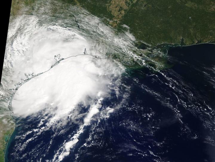
NASA’s Terra Satellite sees the birth of Tropical Storm Imelda
NASA’s Terra satellite passed over the western Gulf of Mexico during the early afternoon of Sept. 17 and captured a visible image of the newly formed Tropical Depression 11. The eleventh tropical depression developed during the late morning of Sept.…

Researchers see need for action on forest fire risk
New statistical approach: changes in forest fires in the 19th and 20th centuries were man-made
NASA-NOAA satellite catches Hurricane Kiko at night
Hurricane Kiko continued to track west through the Eastern Pacific Ocean when NASA-NOAA’s Suomi NPP satellite passed overhead and provided a view of the storm. Satellite imagery revealed an elongated shape, which indicated wind shear was still affecting Kiko. The…
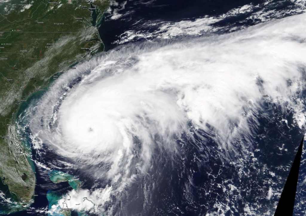
NASA satellite provides a view of a large hurricane Humberto
NASA’s Terra Satellite provided a visible image of Hurricane Humberto when it was off the coast of the Carolinas and slowly moving north. The satellite image revealed that Humberto is a very large storm. On Sept. 16, the Moderate Imaging…

‘Fire inversions’ lock smoke in valleys
Research shows why fire inversions happen and offers new air quality prediction tools
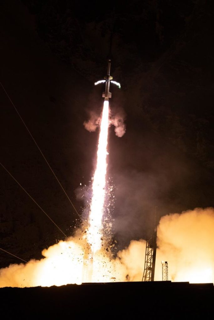
Clemson physicists lead rocket missions to explore Earth’s atmosphere
Clemson University physicists will conduct a pair of three-year rocket missions funded by NASA Helio
NASA finds a few strong storms left in Fernand’s remnants over Northeastern Mexico
Tropical Storm Fernand made landfall in northeastern Mexico and began dissipating. However, infrared imagery from NASA’s Aqua satellite shows that there are still fragmented strong storms left in the tropical cyclone’s remnants. Those storms have the potential to generate heavy…
NASA measures Dorian’s heavy rainfall from Bahamas to Carolinas
Hurricane Dorian continues to generate tremendous amounts of rainfall, and has left over three feet of rain in some areas of the Bahamas and is now lashing the Carolinas. NASA’s IMERG product provided a look at those rainfall totals. By…
NASA-NOAA satellite finds wind shear pushing on Tropical Storm Gabrielle
NASA-NOAA’s Suomi NPP satellite passed over the eastern Atlantic Ocean and infrared data revealed that the storm was being adversely affected by wind shear, pushing its strongest storms northeast of its center. NASA-NOAA’s Suomi NPP satellite used infrared light to…
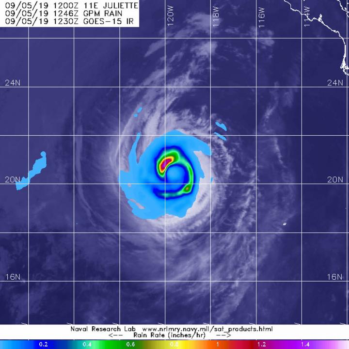
Satellite finds a ‘hook’ of heavy rainfall in Hurricane Juliette
From its vantage point in orbit around the Earth, when the Global Precipitation Measurement mission or GPM core satellite passed over the Eastern Pacific Ocean, it gathered data on rainfall rates occurring in Hurricane Juliette. The areas of strongest rainfall…

Tropical storm Faxai gets a name and NASA gets an infrared picture
Tropical Storm 14W has been moving through the Northwestern Pacific Ocean for several days and has now been renamed Faxai. NASA’s Aqua satellite passed over the newly renamed storm and took the temperature of Faxai’s clouds and storms. NASA’s Terra…
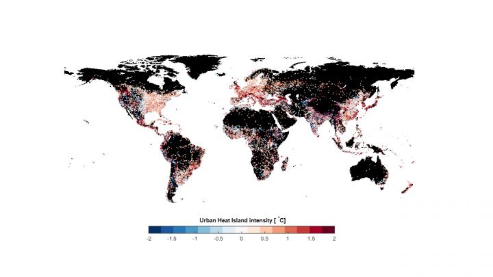
Natural ways of cooling cities
Urban heat islands are a phenomenon where the temperature in a city is noticeably higher than in the surrounding rural area. When combined with the sort of heatwave that hit many parts of Europe at the beginning of July, urban…

GPM finds a band of heavy rainfall in Tropical Storm Gabrielle
The Global Precipitation Measurement mission or GPM core satellite provided information about the rate in which rain was falling within the Eastern Atlantic Ocean’s latest tropical storm, Gabrielle. Tropical Depression 8 formed around 5 p.m. EDT on Tuesday, Sept. 3.…

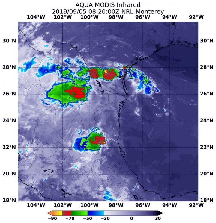
NASA analyzed Tropical Storm Fernand’s strength before landfall
NASA’s Aqua satellite provided forecasters at the National Hurricane Center with infrared data and cloud top temperature information for Tropical Storm Fernand as it was making landfall in northeastern Mexico. Those temperatures indicated Fernand’s rainmaking capabilities. The infrared data also…