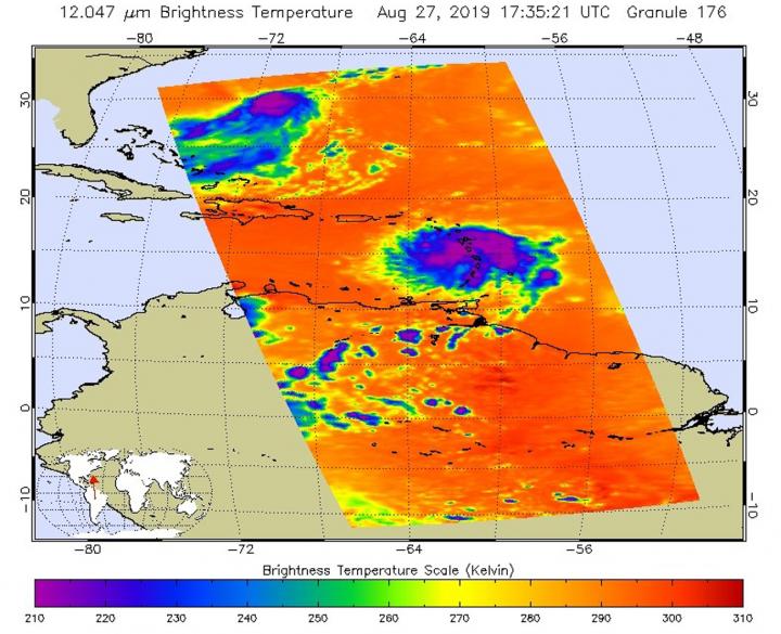
NASA’s Aqua satellite provided forecasters at the National Hurricane Center with visible imagery and infrared data on Tropical Storm Dorian as it continued its western track into the Eastern Caribbean Sea. Infrared data provided an indication of the storm’s heavy rain making potential.
Watches and Warnings
On Wednesday, August 28, 2019, the National Hurricane Center or NHC noted that a Hurricane Watch is in effect for Puerto Rico, Vieques, Culebra, and the U.S. Virgin Islands. A Tropical Storm Warning is in effect for Puerto Rico, Vieques, Culebra, the U.S. Virgin Islands and the British Virgin Islands. A Tropical Storm Watch is in effect for the Dominican Republic from Isla Saona to Samana.
Infrared Temperatures Indicate Strong Storms
Cloud top temperatures provide information to forecasters about where the strongest storms are located within a tropical cyclone. The stronger the storms, the higher they extend into the troposphere, and the colder the cloud top temperatures. NASA’s Aqua satellite analyzed Tropical Storm Dorian’s cloud tops to get that information. AIRS found that some areas in Dorian were being affected by dry air, which was sapping the development of thunderstorms.
The NHC noted that 10-mile wide eye feature developed in Martinique and Guadeloupe radar data between 11 a.m. and 12 p.m. EDT (1500-1600 UTC) around the time Aqua passed over Dorian, and then again between 1 p.m. and 2 p.m. EDT (1700-1800 UTC) around the time the Aqua satellite passed overhead.
NASA’s Aqua satellite analyzed the storm on Aug. 27 at 1:35 p.m. EDT (1735 UTC) using the Atmospheric Infrared Sounder or AIRS instrument. AIRS found coldest cloud top temperatures as cold as or colder than minus 63 degrees Fahrenheit (minus 53 degrees Celsius) around the center and in a thick band of thunderstorms east of the center. NASA research has indicated that cloud top temperatures that cold indicate strong storms that have the capability to create heavy rain.
Heavy Rainfall Expected
NHC forecasters said that Dorian is expected to produce the following rainfall accumulations:
- Western Leeward Islands from Guadeloupe to St. Kitts to Anguilla…1 to 4 inches
- Southern and Eastern Puerto Rico and the U.S. and British Virgin Islands…4 to 6 inches, isolated 10 inches
- Northwestern Puerto Rico…1 to 4 inches
- Haiti and Dominican Republic…1 to 3 inches
- Southern Bahamas…1 to 4 inches
- Northern Bahamas…3 to 6 inches
- Florida Peninsula…4 to 8 inches, isolated 10 inches
This rainfall may cause life-threatening flash floods.
Dorian’s Status at 8 a.m. EDT on August 28, 2019
At 8 a.m. EDT (1200 UTC), the center of Tropical Storm Dorian was located near latitude 17.1 North, longitude 64.1 West.
Dorian is moving toward the northwest near 13 mph (20 kph), and this general motion is expected to continue during the next few days. Maximum sustained winds are near 60 mph (95 kph) with higher gusts. Tropical-storm-force winds extend outward up to 60 miles (95 km) from the center. NHC forecasters said some strengthening is expected today, and Dorian is forecast to be near hurricane strength when it approaches the Virgin Islands and Puerto Rico. An Air Force reconnaissance plane just reported an estimated minimum central pressure of 1003 millibars.
Tropical storm conditions are expected and hurricane conditions are possible in Puerto Rico, Vieques, Culebra, and the U.S. Virgin Islands today. Swells are expected to increase later this morning across the U.S. and British Virgin Islands and along the southern coasts of Puerto Rico and Hispaniola, and they could cause life-threatening surf and rip current conditions.
On the forecast track, the center of Dorian will pass over or near the U.S. and British Virgin Islands and Puerto Rico later today, Aug. 28. Dorian is then forecast to move to the east of the Turks and Caicos and the southeastern Bahamas on Thursday, and near or to the east of the central and northwestern Bahamas on Friday and Saturday.
###
For updated forecasts, visit:
http://www.
By Rob Gutro
NASA’s Goddard Space Flight Center
This part of information is sourced from https://www.eurekalert.org/pub_releases/2019-08/nsfc-nfh082819.php
Rob Gutro
[email protected]
http://www.nasa.gov/goddard


