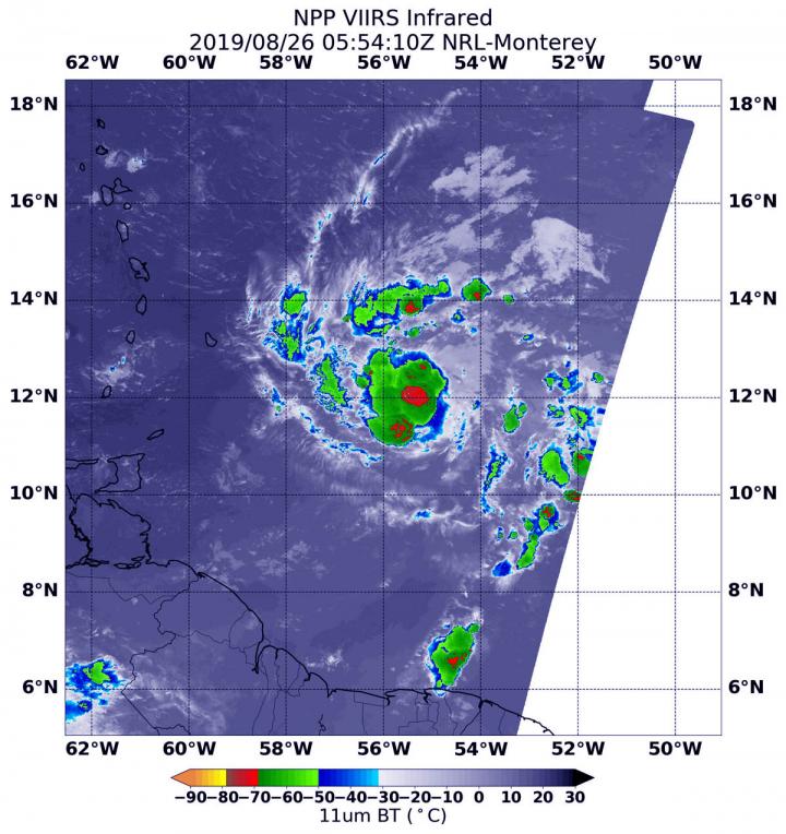
NASA-NOAA’s Suomi NPP satellite passed over Tropical Storm Dorian as it triggered warnings and watches for the islands of the Eastern Caribbean Sea.
On Monday, August 26, 2019, a Tropical Storm Warning is in effect for Barbados, Martinique, St. Lucia, St. Vincent and the Grenadines. A Tropical Storm Watch is in effect for Dominica, Grenada and its dependencies, Saba and St. Eustatius. A Hurricane Watch is in effect for St. Lucia.
Dorian formed as a tropical depression on Saturday, Aug. 24 about 805 miles (1,300 km) east-southeast of Barbados. By 5 p.m. EDT that day, the depression strengthened into a tropical storm and was named Dorian.
NASA-NOAA’s Suomi NPP satellite passed over Tropical Storm Dorian in the western North Atlantic Ocean on Aug. 26 at 1:54 a.m. EDT (0554 UTC). The Visible Infrared Imaging Radiometer Suite (VIIRS) instrument aboard Suomi NPP provided an infrared image of the storm. Infrared imagery reveals cloud top temperatures, and the higher the cloud top, the colder it is, and the stronger the storm. Coldest cloud top temperatures were as cold as minus 70 degrees Fahrenheit (minus 56.6 Celsius) and found around the center of circulation, southwest of the center and in fragmented bands of thunderstorms north of the center. Storms with cloud tops that cold have been found to generate heavy rainfall.
Dorian is a small tropical cyclone. Tropical-storm-force winds only extend outward up to 45 miles (75 km) from the center.
Those areas of strong storms with heavy rainfall potential play into the forecast. NOAA’s National Hurricane Center or NHC said that Dorian is expected to produce total rain accumulations of 3 to 8 inches in the Windward Islands from Martinique south to St. Vincent, including Barbados. Isolated maximum totals of 10 inches are possible across the northern Windward Islands. Rainfall totals of 1 to 3 inches are expected from the Grenadines, south to Grenada and across Dominica.
Satellite microwave imagery has shown a persistent low-level eye-like feature along with an intermittent mid-level eyewall forming that quickly erodes because of dry air entering the storm in the mid-levels of the atmosphere.
At 11 a.m. EDT (1500 UTC) on Monday, August 26, the center of Tropical Storm Dorian was located near latitude 12.3 degrees north and longitude 57.7 degrees west. The center of Dorian was about 135 miles (220 km) east-southeast of Barbados. The estimated minimum central pressure is 1002 millibars.
Dorian is moving toward the west-northwest near 14 mph (22 kph) and this motion is expected to continue through Tuesday night [Aug. 27], followed by a turn toward the northwest on Wednesday [Aug. 28]. Maximum sustained winds are near 60 mph (95 kph) with higher gusts.
Some strengthening is forecast during the next few days, and Dorian could be near hurricane strength when it passes through the northern Windward Islands on Tuesday, and is expected to be a hurricane when it moves near Puerto Rico and eastern Hispaniola.
The National Hurricane Center noted, “Hurricane conditions are possible tonight and early Tuesday within the Hurricane Watch area in the Lesser Antilles. Tropical storm conditions are likely in the warning area by late today. Tropical storm conditions are possible within the tropical storm watch area by tonight or Tuesday. Swells generated by Dorian will be affecting portions of the Lesser Antilles by late today. These swells could cause life-threatening surf and rip current conditions.”
On the forecast track, the center of Dorian is expected to be near the Windward Islands late today and tonight, and move into the eastern Caribbean Sea on Tuesday. Dorian is expected to pass near or south of Puerto Rico on Wednesday and approach eastern Hispaniola Wednesday night.
###
For updated forecasts, visit:
http://www.
nhc.
noaa.
gov
By Rob Gutro
NASA’s Goddard Space Flight Center
This part of information is sourced from https://www.eurekalert.org/pub_releases/2019-08/nsfc-nsf082619.php
Rob Gutro
[email protected]
http://www.nasa.gov/goddard


