“In particular, this study helped us understand the importance of ice shelves, the portion of the ice sheet that hangs into the ocean, and that are most susceptible to melt,” says Matthew Hoffman, a glaciologist and climate modeler at Los Alamos. “Ice shelves are like the cork on a champagne bottle holding everything in. If they weaken, then the ice resting on the ground behind them can flow more quickly into the ocean, leading to rapid sea-level rise.”
The ISMIP6 project, led by NASA’s Goddard Space Flight Center, brought together more than 60 scientists focused on melting ice in Antarctica and Greenland, which contain the world’s largest ice sheets. As the atmosphere and ocean warm, ice sheets contribute to sea-level rise when they melt and flow into the ocean more quickly than they grow new ice from falling snow. To assess the effects of a changing climate, the models simulated ice sheet conditions from 2015 to the end of the century, following both extreme and mitigated warming scenarios.
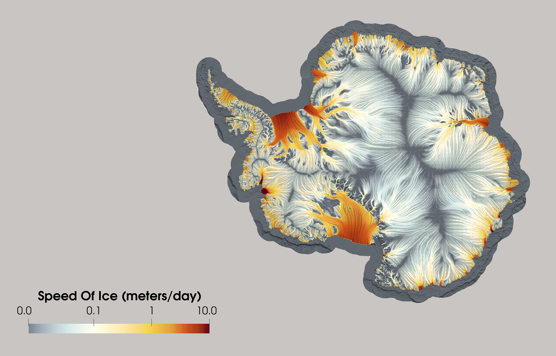
The Laboratory’s work focused on modeling ice changes in Antarctica, using its MPAS Albany Land Ice model (MALI), which was run by Hoffman and Los Alamos scientists Tong Zhang and Stephen Price. Among the 13 models in the project, MALI used the most accurate equations of ice flow and ran at the highest model resolution (each model grid cell representing about one mile of Antarctica), which was enabled by using 6,800 computer processors on Department of Energy supercomputers.
Click here to view the simulation.
Predicting ice melt in Antarctica was more complicated than for Greenland because of its unique geographic setting. In the continent’s east, the simulations project the ice sheet to grow due to warming air temperatures that produce more precipitation. But in the west, warm ocean currents will erode the base of floating ice shelves at a rapid rate, leading to exceptional ice melt and adding up to 7.1 inches of global sea rise alone. This drastic variation, caused by the uniqueness of Antarctica’s climate and geographic setting, is one factor that has always made modeling ice sheet melt on the continent especially difficult.
“The exciting part of this coordinated project using more than a dozen models and multiple climate scenarios is being able to identify what matters most for possible future ice sheet changes,” Hoffman says. “And the most important factors we found were how rapidly the ocean is able to melt the ice from underneath and the amount of future greenhouse gases in the atmosphere.”
The results of the ISMIP6 collaboration, published this week, appear in a special issue of the journal The Cryosphere. The work is part of the Laboratory’s ongoing research to model the impacts of climate change on sea level.
The Laboratory’s expertise in data visualization allowed these high-resolution simulations of Antarctic ice flow to be depicted in unprecedented detail, analysis led by data scientist John Patchett. Laboratory climate scientists Alice Barthel and Xylar Asay-Davis played key roles in preparing the climate model projections used as inputs to the ice sheet modeling.
The research was funded by the Biological and Environmental Research program of the Department of Energy Office of Science. MALI is developed jointly by Los Alamos National Laboratory and Sandia National Laboratories.
Link to special issue: “The Ice Sheet Model Intercomparison Project for CMIP6 (ISMIP6) ”
https://tc.copernicus.org/articles/special_issue1019.html
Laboratory scientists contributed to six of the papers in the special issue.
Link to papers discussed:
“ISMIP6 Antarctica: a multi-model ensemble of the Antarctic ice sheet evolution over the 21st century” in The Cryosphere.
https://doi.org/10.5194/tc-14-3033-2020
https://doi.org/10.5194/tc-14-3071-2020
“CMIP5 model selection for ISMIP6 ice sheet model forcing: Greenland and Antarctica”
https://doi.org/10.5194/tc-14-855-2020
“A protocol for calculating basal melt rates in the ISMIP6 Antarctic ice sheet projections”
https://doi.org/10.5194/tc-14-3111-2020
About Los Alamos National Laboratory
Los Alamos National Laboratory, a multidisciplinary research institution engaged in strategic science on behalf of national security, is managed by Triad, a public service oriented, national security science organization equally owned by its three founding members: Battelle Memorial Institute (Battelle), the Texas A&M University System (TAMUS), and the Regents of the University of California (UC) for the Department of Energy’s National Nuclear Security Administration.
Los Alamos enhances national security by ensuring the safety and reliability of the U.S. nuclear stockpile, developing technologies to reduce threats from weapons of mass destruction, and solving problems related to energy, environment, infrastructure, health, and global security concerns.
LA-UR-20-27086

