On a new study (DOI: 10.1186/s43020-023-00126-1) recently published in the journal Satellite Navigation, researchers from Shandong Universityhave developed an innovative calibration algorithm for the Inertial Measurement Unit (IMU), significantly improving navigation performance through acoustic LBL-based calibration.
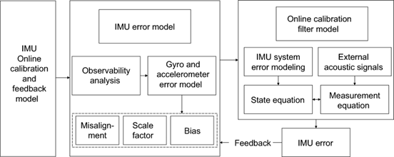
The core of this groundbreaking study lies in its innovative approach to overcoming the limitations of traditional underwater navigation methods. Researchers have ingeniously developed a calibration algorithm that integrates acoustic signals from seabed beacons with the data from an IMU onboard underwater vehicles. This integration allows for real-time correction of the IMU’s cumulative errors, which are a significant hurdle in the path of accurate and extended underwater navigation. The experiment focused on calibrating the IMU by employing an acoustic LBL system. When the vehicle is within the LBL network and can receive acoustic signals from the seafloor beacons, these signals are used to recalibrate the IMU, thereby significantly reducing the navigational errors. The research pinpoints gyroscope and accelerometer biases as the primary culprits behind navigational inaccuracies. Through extensive experimentation and analysis, it was discovered that correcting these biases through the proposed calibration method could enhance navigation precision remarkably.
Dr. Wenfeng Nie, a leading researcher in the study, highlights the significance of their work, “Our research introduces a method to calibrate the IMU using acoustic signals from seafloor beacons, allowing underwater vehicles to maintain accuracy even outside the direct coverage of LBL networks. This breakthrough promises to extend the operational range and precision of underwater navigation significantly.”
This technological advancement heralds a new era in underwater exploration, offering the potential for more accurate, reliable, and extended operations beneath the ocean’s surface. It’s a pivotal step towards unlocking the mysteries of the deep, enabling safer and more efficient exploration, research, and resource extraction activities.
###
References
DOI
Original Source URL
https://doi.org/10.1186/s43020-023-00126-1
Funding information
This study is sponsored by Laoshan Laboratory (No. LSKJ202205100, LSKJ202205104), National Natural Science Foundation of China (41931076) and the Young Scholars Program of Shandong University, Weihai.
About Satellite Navigation
Satellite Navigation (E-ISSN: 2662-1363; ISSN: 2662-9291) is the official journal of Aerospace Information Research Institute, Chinese Academy of Sciences. The aims is to report innovative ideas, new results or progress on the theoretical techniques and applications of satellite navigation. The journal welcomes original articles, reviews and commentaries.

