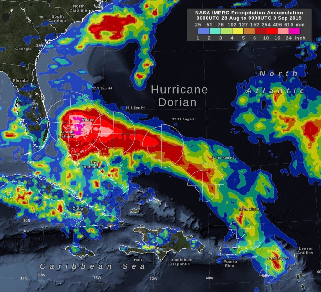
In the early hours of Tuesday, September 3, Hurricane Dorian had been stationary over the island of Grand Bahama for 18 hours, most of the time as a category 5 hurricane. Storm-total rain accumulation over parts of Grand Bahama and Abaco Islands have exceeded 24 inches according to NASA satellite-based estimates.
On early Tuesday morning, Dorian’s central pressure had risen and its wind intensity had dropped to category 4 on the Saffir-Simpson scale. In addition, Dorian had experienced an eyewall replacement cycle on September 2, so by Tuesday morning Sept. 3, the geographic extent of its tropical-storm-force winds had expanded.
These rain estimates come from the NASA IMERG algorithm, which combines observations from a fleet of satellites, in near-realtime, to provide global estimates of precipitation every 30 minutes. The storm-total rainfall at a particular location varies with the forward speed of the hurricane, with the size of the hurricane’s wind field, and with how vigorous the updrafts are inside of the hurricane’s eyewall.
IMERG, or the Integrated Multi-satellitE Retrievals for GPM (IMERG) data product is generated by NASA’s Precipitation Processing System every half hour with a 6 hour latency from the time of data acquisition. It is produced using data from the satellites in the GPM or Global Precipitation Measurement mission constellation of satellites, and is calibrated with measurements from the GPM Core Observatory as well as rain gauge networks around the world.
IMERG is an example of the research role that NASA has in hurricanes – developing observational tools and building computer models to better understand the behavior of tropical cyclones. NASA’s research data is utilized by NOAA’s National Hurricane Center (NHC) to enhance their forecasts.
On Tuesday, September 3, 2019, at 8 a.m. EDT (1200 UTC), NHC reported at the eye of Hurricane Dorian was located by reconnaissance aircraft and NOAA Doppler radar near latitude 27.1 degrees North and longitude 78.4 degrees West. NHC said Dorian is beginning to move northwestward at about 1 mph (2 kph), and a slightly faster motion toward the northwest or north-northwest is expected later today and tonight.
At present maximum sustained winds are near 120 mph (195 kph) with higher gusts. Dorian is a category 3 hurricane on the Saffir-Simpson Hurricane Wind Scale. Dorian is expected to remain a powerful hurricane during the next couple of days. Hurricane-force winds extend outward up to 45 miles (75 km) from the center, and tropical-storm-force winds extend outward up to 160 miles (260 km). The latest minimum central pressure reported by reconnaissance aircraft is 952 mb (28.11 inches).
NHC forecasts a turn toward the north by Wednesday evening, followed by a turn to the north-northeast Thursday morning. On this track, the core of extremely dangerous Hurricane Dorian will gradually move north of Grand Bahama Island through this evening. The hurricane will then move dangerously close to the Florida east coast late today through Wednesday evening, very near the Georgia and South Carolina coasts Wednesday night and Thursday, and near or over the North Carolina coast late Thursday.
###
For updated forecasts, visit:
http://www.
nhc.
noaa.
gov
For more about NASA’s IMERG, visit:
https:/
/
pmm.
nasa.
gov/
gpm/
imerg-global-image
By Owen Kelly / with NOAA’s NHC Update
This part of information is sourced from https://www.eurekalert.org/pub_releases/2019-09/nsfc-nie090319.php
Rob Gutro
[email protected]
http://www.nasa.gov/goddard


