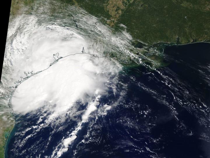
NASA’s Terra satellite passed over the western Gulf of Mexico during the early afternoon of Sept. 17 and captured a visible image of the newly formed Tropical Depression 11.
The eleventh tropical depression developed during the late morning of Sept. 17. Soon afterward it briefly strengthened into a tropical storm and was re-named Imelda. Then Imelda made landfall near Freeport, Texas. A Tropical Storm Warning was in effect from Sargent to Port Bolivar, Texas.
On Sept. 17 at 1:30 p.m. EDT (17:30 UTC), the Moderate Imaging Spectroradiometer or MODIS instrument that flies aboard NASA’s Terra satellite provided a visible picture of the storm shortly after it made landfall on the southeastern Texas coastline. The storm appeared to be slightly elongated, and when Terra passed overhead the western quadrant of the storm was already over land while the eastern half was over the western Gulf of Mexico.
At 1 p.m. EDT (1700 UTC), the center of Tropical Storm Imelda was located near latitude 28.7 North, longitude 95.4 West. The storm is moving toward the north near 7 mph (11 kph), and this general motion is expected to continue through early Wednesday. Maximum sustained winds are near 35 mph (55 kph), tropical storm strength, with higher gusts. Some slight strengthening is possible before the center moves onshore. The estimated minimum central pressure is 1009 millibars.
For local Houston area radar, visit:
https:/
/
www.
weather.
gov/
hgx/
A north-northwestward motion is expected Wednesday night and Thursday. On the forecast track, the center of the depression will move inland over the Upper Texas coast later today, and move farther inland tonight and Wednesday.
###
For updated forecasts, visit:
https:/
/
www.
nhc.
noaa.
gov
Rob Gutro
NASA’s Goddard Space Flight Center.
This part of information is sourced from https://www.eurekalert.org/pub_releases/2019-09/nsfc-nts091719.php
Rob Gutro
[email protected]
http://www.nasa.gov/goddard


