On Dec. 6 local time (Dec. 5 in the United States), Japanese spacecraft Hayabusa2 dropped a capsule to the ground of the Australian Outback from about 120 miles (or 200 kilometers) above Earth’s surface. Inside that capsule is some of…
Tag: Meteorology

The climate changed rapidly alongside sea ice decline in the north
Researchers from the Niels Bohr Institute, University of Copenhagen have, in collaboration with Norwegian researchers in the ERC Synergy project, ICE2ICE, shown that abrupt climate change occurred as a result of widespread decrease of sea ice.
Planetary scientist named key partner on NASA’s Lunar Trailblazer mission
Christopher Edwards joins multi-institutional team led by Caltech to design and build instrumentation for satellite to study the Moon’s water cycle and make critical basemaps
Climate change and ‘atmospheric thirst’ to increase fire danger and drought in NV and CA
New study shows impacts of increased levels of evaporative demand as climate grows warmer and drier
Chemical physicist to collaborate on NASA-funded study of Saturn’s moon Titan
Findings will contribute to NASA’s mission to Titan in 2026
Heat and dust help launch Martian water into space, scientists find
Scientists using an instrument aboard NASA’s Mars Atmosphere and Volatile EvolutioN, or MAVEN, spacecraft have discovered that water vapor near the surface of the Red Planet is lofted higher into the atmosphere than anyone expected was possible. There, it is…
Aurora-chasing citizen scientists help discover a new feature of STEVE
In 2018, a new aurora-like discovery struck the world. From 2015 to 2016, citizen scientists reported 30 instances of a purple ribbon in the sky, with a green picket fence structure underneath. Now named STEVE, or Strong Thermal Emission Velocity…
NASA deems SwRI-developed satellites healthy, extends CYGNSS mission
Hurricane wind monitoring mission will continue through 2023
Climatologist Warren Knapp, acid rain expert, dies at 82
Warren Knapp, professor emeritus of meteorology and climate in the Department of Earth and Atmospheric Sciences at Cornell University, and the second director of Cornell’s Northeast Regional Climate Center, died Oct. 3 in Ithaca. He was 82.
Recipe for a storm
Scientists from the University of Oldenburg generate realistic storm turbulence in the laboratory

Expect more mega-droughts
Mega-droughts – droughts that last two decades or longer – are tipped to increase thanks to climate change, according to University of Queensland-led research.
“Fireball” meteorite contains pristine extraterrestrial organic compounds
On the night of January 16, 2018, a fireball meteor streaked across the sky over the Midwest and Ontario before landing on a frozen lake in Michigan. Scientists used weather radar to find where the pieces landed and meteorite hunters…
Rutgers Expert Available to Discuss Vietnam’s Vulnerability to Floods
New Brunswick, N.J. (Oct. 23, 2020) – Rutgers Professor Pamela McElwee, an expert on Vietnam environmental issues, is available for interviews on the devastating flooding in that country this month and the flood threat posed by Typhoon Saudel. McElwee, who has done research…
NASA finds wind shear affecting Tropical Storm Nangka post-landfall
Tropical Storm Nangka made landfall south of Haiphong, Vietnam and began to weaken. NASA’s Aqua satellite revealed wind shear was affecting the storm as it continued to push inland. The Moderate Resolution Imaging Spectroradiometer or MODIS instrument that flies aboard…
NASA rainfall imagery reveals Norbert regains tropical storm status
Norbert has been meandering around in the Eastern Pacific Ocean for several days as a tropical depression. A NASA satellite rainfall product that incorporates data from satellites and observations revealed that Norbert has regained tropical storm status after showing increased…
The mountains of Pluto are snowcapped, but not for the same reasons as on Earth
In 2015, the New Horizons space probe discovered spectacular snowcapped mountains on Pluto, which are strikingly similar to mountains on Earth. Such a landscape had never before been observed elsewhere in the Solar System. However, as atmospheric temperatures on our…
NASA animation tracks the end of Tropical Storm Delta
NASA’s Terra satellite obtained visible imagery as Tropical Storm Delta made landfall in Louisiana and moved northeastward soaking the U.S. southeast and Mid-Atlantic states. NASA Satellite View: Delta’s Organization The Moderate Resolution Imaging Spectroradiometer or MODIS instrument that flies aboard…
NASA sees Tropical Storm Nangka soaking Hainan Island
Using a NASA satellite rainfall product that incorporates data from satellites and observations, NASA estimated Nangka’s rainfall rates as the storm soaked Hainan Island, China early on Oct. 13 (EDT). Nangka formed in the South China Sea and moved in…
NASA shows heaviest rainfall displaced in Typhoon Chan-hom
Typhoon Chan-hom was still moving parallel to Japan’s east coast as NASA’s satellite rainfall product, that incorporates data from satellites and observations, showed its heaviest rainfall was pushed northeast of center. Chan-hom’s Status on Oct. 9 At 5 a.m. EDT…
NASA finds hurricane delta packing heavy rainfall
NASA’s satellite rainfall product that incorporates data from satellites and observations found that Hurricane Delta was bringing along heavy rainfall as it headed to the U.S. Gulf Coast on Oct. 9. Warnings and Watches in Effect on Oct. 9 There…
NASA examines Hurricane Delta’s early morning structure
The NASA-NOAA Suomi NPP satellite provided two nighttime views of Hurricane Delta as it moved toward the U.S. Gulf Coast. A moonlit image and an infrared image revealed the extent and organization of the intensifying hurricane. Satellite Imagery Shows Delta’s…
NASA finds dry air sapping Tropical Storm Norbert’s strength
Infrared imagery from NASA’s Aqua satellite revealed that dry air is eroding Tropical Storm Norbert, located off the coast of southwestern Mexico. Infrared Data Reveals Dry Air Effects On Oct. 7 at 4:30 a.m. EDT (0830 UTC), the Moderate Resolution…
NASA analyzes Hurricane Delta’s water vapor concentration
When NASA’s Aqua satellite passed over the Caribbean Sea on Oct. 7, it gathered water vapor data on Hurricane Delta as Mexico’s Yucatan continues to feel its effects. Water vapor analysis of tropical cyclones tells forecasters how much potential a…
NASA analyzes rainfall around Typhoon Chan-hom’s ragged eye
A NASA satellite rainfall product that incorporates data from satellites and observations found heavy rainfall occurring throughout Typhoon Chan-hom and the heaviest rainfall in the eyewall. Chan-hom is expected to bring rainfall to Japan on its track through the Northwestern…
Infrared NASA imagery finds Chan-hom organizing, consolidating
NASA’s Aqua satellite analyzed the large Tropical Storm Chan-hom as it tracked through the Northwestern Pacific Ocean. Aqua imagery showed the storm was consolidating, indicating a strengthening trend. One of the ways NASA researches tropical cyclones is using infrared data…
NASA catches development of Tropical Storm Norbert as Marie declines
NASA-NOAA’s Suomi NPP satellite passed over the Eastern Pacific Ocean and captured the birth of a depression that became Tropical Storm Norbert while Marie continued weakening while headed toward the Central Pacific. Tropical Depression 19E formed well offshore of southwestern…
NASA-NOAA satellite finds Hurricane Delta rapidly intensifying
Infrared imagery from NASA-NOAA’s Suomi NPP satellite revealed that Hurricane Delta has been rapidly growing stronger and more powerful. Infrared imagery revealed that powerful thunderstorms circled the eye of the hurricane and southern quadrant as it moved through the Caribbean…
NASA gages Tropical Storm Delta’s strength in infrared
NASA’s Aqua satellite analyzed Tropical Storm Delta in infrared imagery as it moved through the Caribbean Sea. The imagery provided cloud top temperatures to identify the strongest areas within the storm. Potential Tropical Cyclone 26 formed in the Caribbean Sea…
NASA infrared imagery reveals wind shear displacing Marie’s strongest storms
NASA’s Aqua satellite provided an infrared view of Tropical Storm Marie that revealed the effects of outside winds battering the storm. Wind shear occurs when winds at different levels of the atmosphere push against the rotating cylinder of winds, weakening…
NASA imagery reveals Tropical Storm Chan-hom’s skewed structure
NASA’s Terra satellite obtained visible imagery of Tropical Storm Chan-hom as it continued moving though the Northwestern Pacific Ocean. The imagery revealed that the center of circulation was exposed and its strongest storms were south of the center. Tropical Depression…
NASA imagery reveals Tropical Storm Gamma battered by wind shear
NASA’s Terra satellite obtained visible imagery of Tropical Storm Gamma being battered by outside winds in the south central Gulf of Mexico. Over the weekend of Oct. 3 and 4, Gamma tracked over Mexico’s Yucatan Peninsula. Tropical Depression 25 formed…
NASA finds heavy rainfall ringing major Hurricane Maria’s eye
Imagine being able to look down at a storm from orbit in space, and provide data that lets scientists calculate the rate in which rain is falling throughout it. That is what a NASA satellite rainfall product does as it…
NASA finds Hurricane Marie rapidly intensifying
NASA infrared imagery revealed that Hurricane Marie is rapidly growing stronger and more powerful. Infrared imagery revealed that powerful thunderstorms circled the eye of the hurricane as it moved through the Eastern Pacific Ocean. NOAA’s National Hurricane Center (NHC) expects…
NASA confirms, heavy rainfall, strengthening of tropical storm Marie
Tropical Storm Marie has formed in the Eastern Pacific Ocean and NASA satellite data helped confirm the strengthening of the storm. In addition, using a NASA satellite rainfall product that incorporates data from satellites and observations, NASA estimated Marie’s rainfall…
NASA imagery reveals Kujira transitioning into an extratropical cyclone
Tropical cyclones can become post-tropical before they dissipate, meaning they can become sub-tropical, extra-tropical or a remnant low-pressure area. NASA’s Aqua satellite provided a visible image that showed Typhoon Kujira transitioning into an extra-tropical storm, and the effects of strong…
NASA’s infrared view of typhoon Kujira
NASA’s Terra satellite used infrared light to identify strongest storms and coldest cloud top temperatures in Typhoon Kujira as it tracked through the northwestern Pacific Ocean. Infrared Data Reveals Most Powerful Storms Infrared data provides temperature information about the cloud…
NASA casts an infrared eye on Tropical Storm Kujira’s very cold cloud tops
NASA analyzed the cloud top temperatures in Tropical Storm Kujira using infrared light to determine the strength of the storm. Infrared imagery revealed that the strongest storms were around Kujira’s center and in a band of thunderstorms on the western…
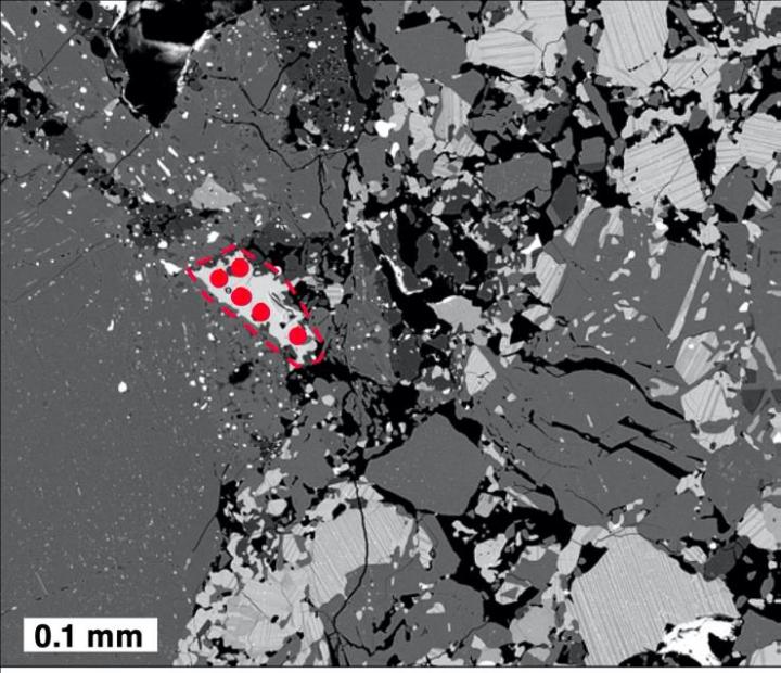
Remnants of an ancient asteroid shed new light on the early solar system
Researchers have shaken up a once accepted timeline for cataclysmic events in the early solar system.
NASA finds wind shear displacing Lowell’s strongest storms
NASA’s Aqua satellite provided an infrared view of Tropical Storm Lowell that revealed the effects of outside winds battering the storm. Wind shear occurs when winds at different levels of the atmosphere push against the rotating cylinder of winds, weakening…
NASA finds post-tropical storm Beta’s clouds blanketing the Southeastern US
NASA’s Terra satellite obtained visible imagery of Post-Tropical Cyclone Beta as it continued moving slowly through the Tennessee Valley. Clouds associated with the low-pressure area looked like a large white blanket draped across much of the southeastern U.S. On Sept.…

Solving the strange storms on Jupiter
At the south pole of Jupiter lurks a striking sight–even for a gas giant planet covered in colorful bands that sports a red spot larger than the earth.
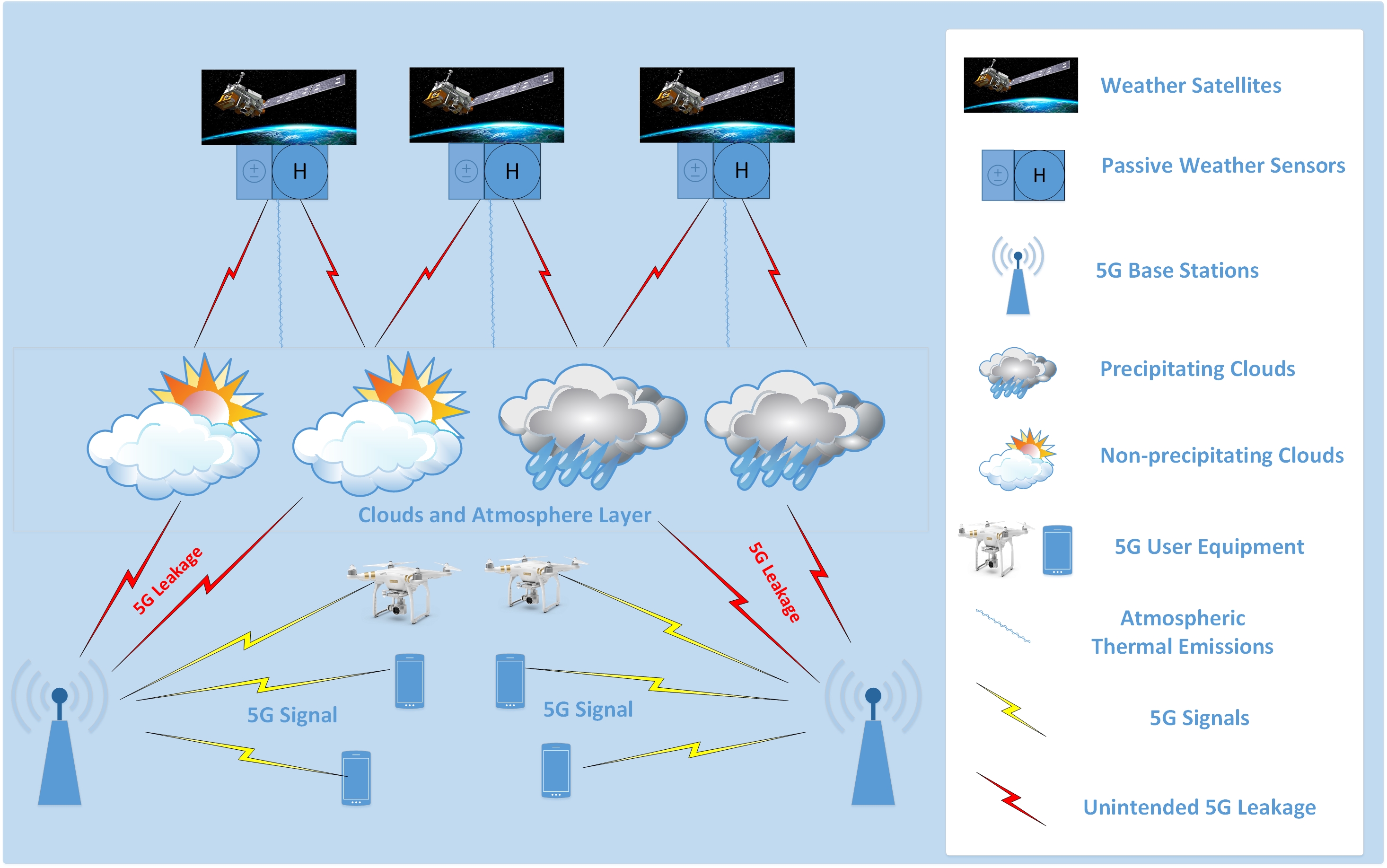
5G Wireless May Lead to Inaccurate Weather Forecasts
Upcoming 5G wireless networks that will provide faster cell phone service may lead to inaccurate weather forecasts, according to a Rutgers study on a controversial issue that has created anxiety among meteorologists.
NASA estimating Beta’s rains moving into the Tennessee valley
Using a NASA satellite rainfall product that incorporates data from satellites and observations, NASA estimated Post-tropical Cyclone Beta’s rainfall rates as it moved over Mississippi, Alabama and Tennessee. Beta continues a steady northeast track into Mississippi, bringing heavy rainfall across…
NASA nets Dolphin as an extratropical storm
NASA’s Aqua satellite caught a visible image of Dolphin after it passed east central Japan on Sept. 24, where it became an extratropical storm in the Northwestern Pacific Ocean. At 11 p.m. EDT on Sept. 23 (0300 UTC on Sept.…
NASA-NOAA satellite finds wind shear affecting Tropical Storm Lowell
NASA-NOAA’s Suomi NPP satellite passed over the Eastern North Pacific Ocean and captured a visible image of Tropical Storm Lowell that revealed the storm was dealing with wind shear. Wind shear is caused by winds outside of a tropical cyclone…
Post-Tropical Storm Teddy in NASA Newfoundland nighttime view
NASA-NOAA’s Suomi NPP satellite provided an infrared image of Post-tropical cyclone Teddy over the province of Newfoundland, Canada in the early morning hours of Sept. 24. Teddy’s Last Advisory At 11 p.m. EDT on Sept. 23 (0300 UTC on Sept.…
Rutgers Experts Can Discuss Fall Foliage Outlook in N.J.
New Brunswick, N.J. (Sept. 23, 2020) – Rutgers University–New Brunswick climatologist David A. Robinson and tree expert Jason Grabosky are available for interviews on the outlook for the fall foliage season in the Garden State. “Seasonable temperatures, including some cool nights, and adequate rainfall during…
NASA sees post-tropical storm Teddy generating heavy rain over Eastern Canada
Hurricane Teddy has transitioned to a large post-tropical cyclone over eastern Canada. Using a NASA satellite rainfall product that incorporates data from satellites and observations, NASA estimated Teddy’s rainfall rates. In addition to the heavy rainfall, Teddy causing destructive waves…
NASA finds Dolphin swimming against wind shear
NASA’s Terra satellite provided a visible image of a slightly elongated Tropical Storm Dolphin as it battled wind shear upon its approach to east central Japan. A Visible Satellite Image The Moderate Resolution Imaging Spectroradiometer or MODIS instrument that flies…
NASA finds Tropical Storm Lowell’s center north of strongest side
NASA’s Aqua satellite used infrared light to identify strongest storms and coldest cloud top temperatures in Tropical Storm Lowell and found them south of the center of circulation. Lowell is moving through the Eastern Pacific Ocean and far from land…