The bulk of Typhoon Mitag’s clouds and precipitation has been pushed north of its center, extending its reach over the East China Sea. Mitag was centered just off the coast of China’s Zhejiang province when NASA-NOAA’s Suomi NPP satellite passed…
Tag: Meteorology
NASA finds tropical storm Narda bringing heavy rainfall to western Mexico
NASA’s Aqua satellite captured an image of Tropical Storm Narda along Mexico’s west coast in the Eastern Pacific Ocean. Satellite data revealed the potential for heavy rainfall within Narda, and warnings are in effect for portions of western Mexico. Narda…
NASA finds Typhoon Mitag’s eye east of Taiwan
NASA’s Terra satellite captured an image of Typhoon Mitag’s cloud-filled eye, located east of Taiwan. On Sept. 30, the Moderate Imaging Spectroradiometer or MODIS instrument that flies aboard NASA’s Terra satellite provided a visible image of Mitag. The MODIS image…
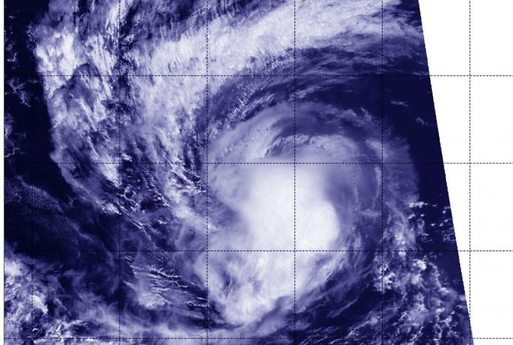
NASA-NOAA’s Suomi NPP analyzes record-setting hurricane Lorenzo
Over the weekend of Sept. 28 and 29, Hurricane Lorenzo attained Category 5 strength briefly, becoming the strongest hurricane on record in the eastern-most Atlantic Ocean. Lorenzo has also attained and contributed to some other significant statistics. NASA-NOAA’s Suomi NPP…
NASA data stares into the eye of powerful hurricane Lorenzo
Satellite data has confirmed that Lorenzo is a major hurricane in the eastern North Atlantic Ocean with an impressive structure. NASA’s Terra Satellite provided a visible image of Lorenzo that revealed a clear eye and a solid structure of thunderstorms…
NASA Satellite finds Karen holding onto tropical storm status
NASA’s Terra Satellite provides a variety of data on tropical cyclones including cloud heights and cloud top temperatures. Terra examined those factors in Tropical Storm Karen in the North Atlantic Ocean and data showed Karen holding onto tropical storm status.…
NASA-NOAA satellite sees Tropical Depression 19W organizing
NASA-NOAA’s Suomi NPP satellite passed over the Northwestern Pacific Ocean and provided forecasters at the Joint Typhoon Warning Center with a view of Tropical Depression 19W’s structure that helped confirm it is now a depression. On Sept. 27, 2019, the…
NASA finds light rain in former hurricane Kiko’s remnants
Former Hurricane Kiko is now just a remnant low pressure area that has slid into the Central Pacific Ocean. The Global Precipitation Measurement mission or GPM satellite provided a look at the rainfall occurring within the low. Kiko weakened to…
NASA-NOAA satellite finds Jerry now a post-tropical storm
NASA-NOAA’s Suomi NPP satellite passed over Jerry and provided forecasters with a view of its structure that helped confirm it is now post-tropical. On Sept. 25 at 12:48 p.m. EDT (1806 UTC), the Visible Infrared Imaging Radiometer Suite (VIIRS) instrument…
NASA finds Tropical Storm Karen bringing heavy rain to Puerto Rico
Tropical Storm Karen has crossed over Puerto Rico and into the western Atlantic Ocean. Early on Sept. 25 when Global Precipitation Measurement mission or GPM core satellite passed overhead, the satellite found heavy rain occurring over the territory. The GPM’s…
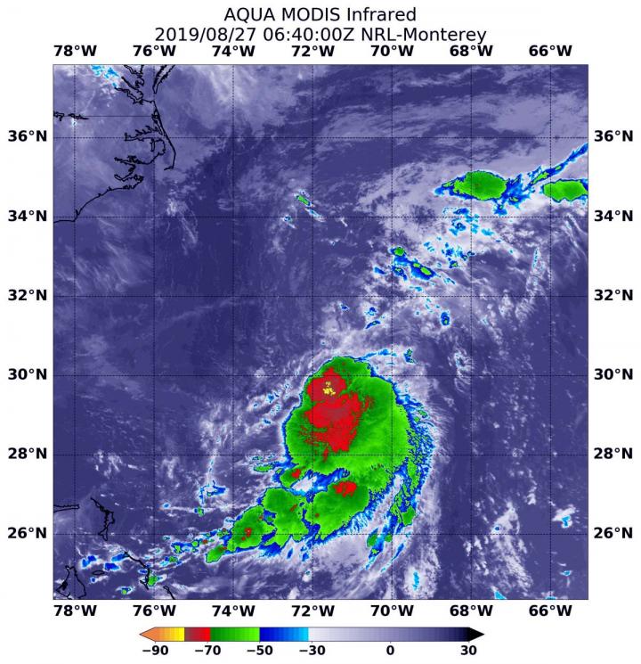
NASA-NOAA satellite sees Hurricane Lorenzo strengthening
Dropping cloud top temperatures from NASA-NOAA’s Suomi NPP satellite indicated Hurricane Lorenzo was getting stronger in the North Atlantic Ocean. The Visible Infrared Imaging Radiometer Suite (VIIRS) instrument aboard Suomi NPP provided an infrared image of the storm. Infrared imagery…

Dust from a giant asteroid crash caused an ancient ice age
About 466 million years ago, long before the age of the dinosaurs, the Earth froze. The seas began to ice over at the Earth’s poles, and the new range of temperatures around the planet set the stage for a boom…
NASA-NOAA satellite catches Hurricane Kiko at night
Hurricane Kiko continued to track west through the Eastern Pacific Ocean when NASA-NOAA’s Suomi NPP satellite passed overhead and provided a view of the storm. Satellite imagery revealed an elongated shape, which indicated wind shear was still affecting Kiko. The…
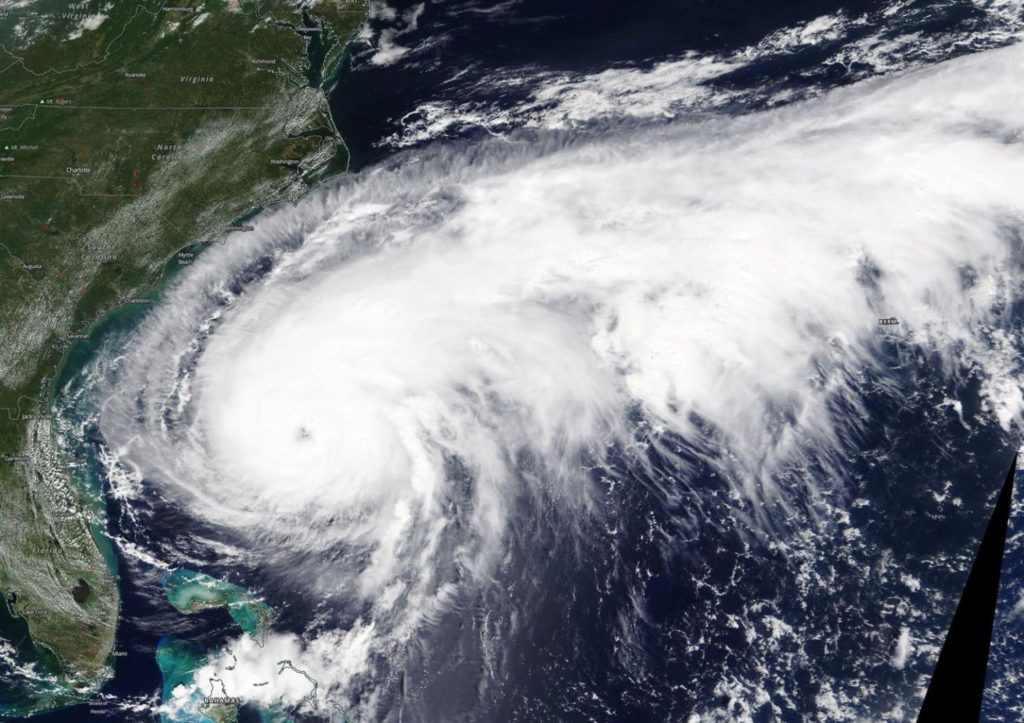
NASA satellite provides a view of a large hurricane Humberto
NASA’s Terra Satellite provided a visible image of Hurricane Humberto when it was off the coast of the Carolinas and slowly moving north. The satellite image revealed that Humberto is a very large storm. On Sept. 16, the Moderate Imaging…
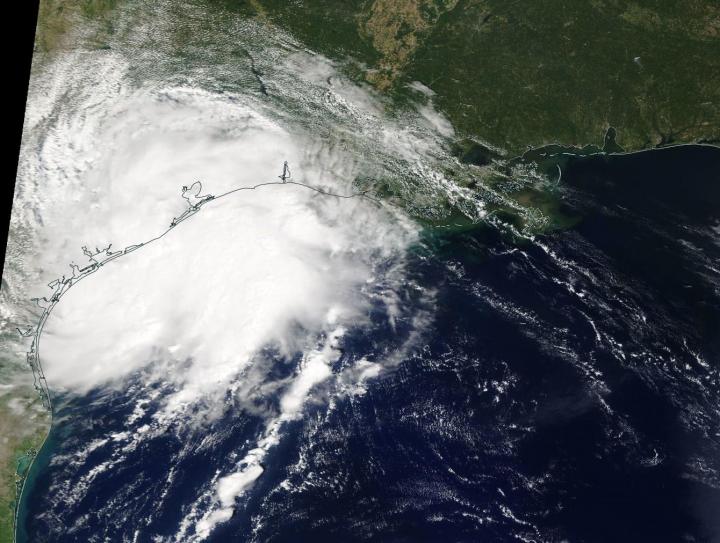
NASA’s Terra Satellite sees the birth of Tropical Storm Imelda
NASA’s Terra satellite passed over the western Gulf of Mexico during the early afternoon of Sept. 17 and captured a visible image of the newly formed Tropical Depression 11. The eleventh tropical depression developed during the late morning of Sept.…
NASA finds a few strong storms left in Fernand’s remnants over Northeastern Mexico
Tropical Storm Fernand made landfall in northeastern Mexico and began dissipating. However, infrared imagery from NASA’s Aqua satellite shows that there are still fragmented strong storms left in the tropical cyclone’s remnants. Those storms have the potential to generate heavy…
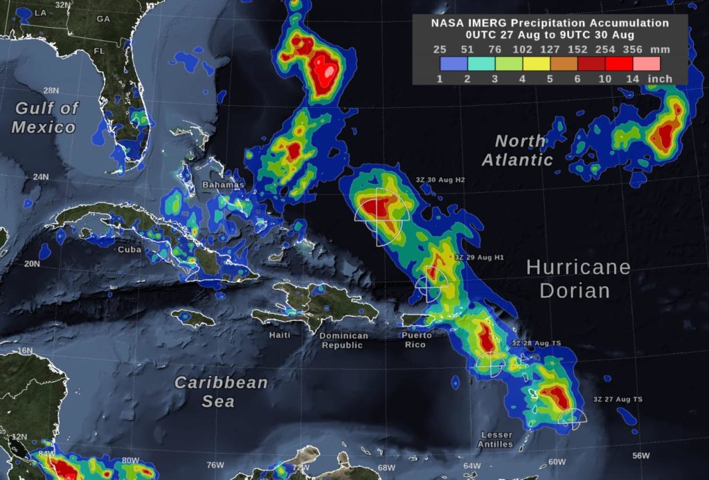
NASA measures Dorian’s heavy rainfall from Bahamas to Carolinas
Hurricane Dorian continues to generate tremendous amounts of rainfall, and has left over three feet of rain in some areas of the Bahamas and is now lashing the Carolinas. NASA’s IMERG product provided a look at those rainfall totals. By…
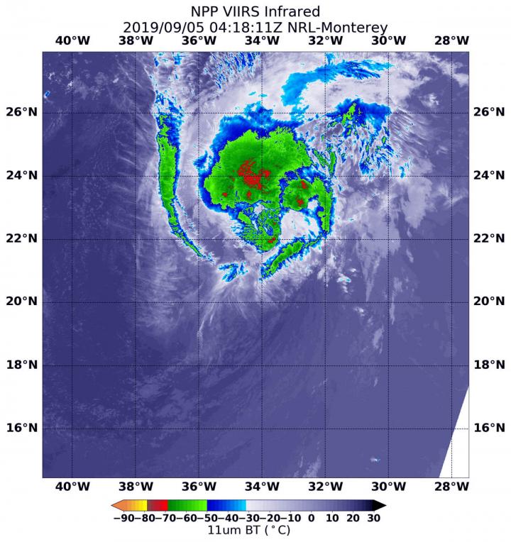
NASA-NOAA satellite finds wind shear pushing on Tropical Storm Gabrielle
NASA-NOAA’s Suomi NPP satellite passed over the eastern Atlantic Ocean and infrared data revealed that the storm was being adversely affected by wind shear, pushing its strongest storms northeast of its center. NASA-NOAA’s Suomi NPP satellite used infrared light to…
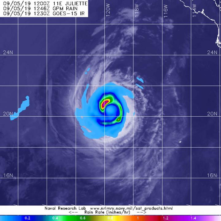
Satellite finds a ‘hook’ of heavy rainfall in Hurricane Juliette
From its vantage point in orbit around the Earth, when the Global Precipitation Measurement mission or GPM core satellite passed over the Eastern Pacific Ocean, it gathered data on rainfall rates occurring in Hurricane Juliette. The areas of strongest rainfall…

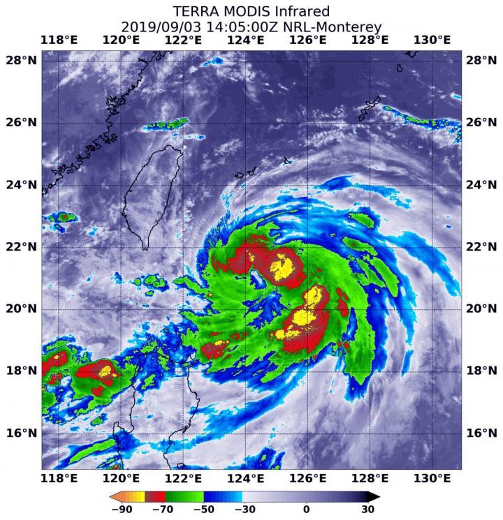
Tropical storm Faxai gets a name and NASA gets an infrared picture
Tropical Storm 14W has been moving through the Northwestern Pacific Ocean for several days and has now been renamed Faxai. NASA’s Aqua satellite passed over the newly renamed storm and took the temperature of Faxai’s clouds and storms. NASA’s Terra…

NASA analyzed Tropical Storm Fernand’s strength before landfall
NASA’s Aqua satellite provided forecasters at the National Hurricane Center with infrared data and cloud top temperature information for Tropical Storm Fernand as it was making landfall in northeastern Mexico. Those temperatures indicated Fernand’s rainmaking capabilities. The infrared data also…
NASA catches Hurricane Juliette over Mexico’s Socorro Island
Although Hurricane Juliette is no longer a major hurricane in the Eastern Pacific Ocean, NASA’s Aqua satellite revealed there are still powerful thunderstorms around its center and captured an image of the storm over Socorro Island, Mexico. Aqua provided forecasters…
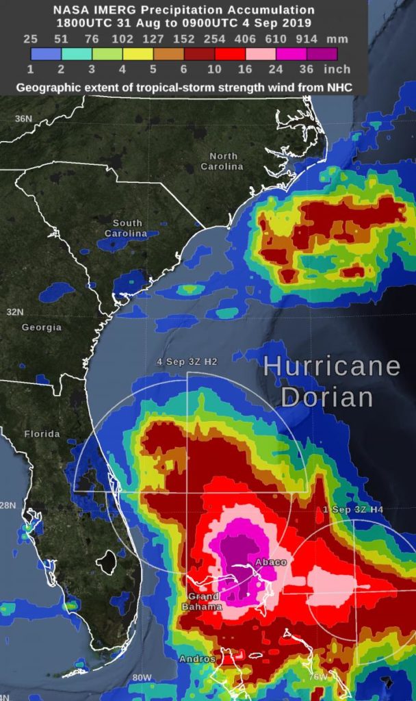
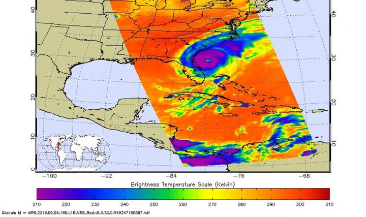
NASA estimates Hurricane Dorian’s massive Bahama rainfall totals
Hurricane Dorian dropped excessive rainfall on the Bahamas and NASA calculated the rainfall the storm generated. “By Wednesday morning, September 4, the rain accumulation from Hurricane Dorian exceeded 36 inches in an area that included parts of Grand Bahama Island…

GPM finds a band of heavy rainfall in Tropical Storm Gabrielle
The Global Precipitation Measurement mission or GPM core satellite provided information about the rate in which rain was falling within the Eastern Atlantic Ocean’s latest tropical storm, Gabrielle. Tropical Depression 8 formed around 5 p.m. EDT on Tuesday, Sept. 3.…
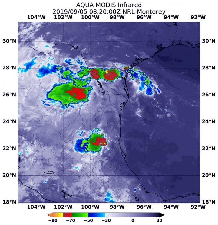
NASA infrared data reveals rainmaking potential in tropical depression 7
Another Atlantic Ocean basin depression formed while Hurricane Dorian is still wreaking havoc on the Bahamas and affecting the southeastern U.S. Infrared imagery from NASA’s Aqua satellite shows that Tropical Depression 7 in the western Gulf of Mexico has developed…
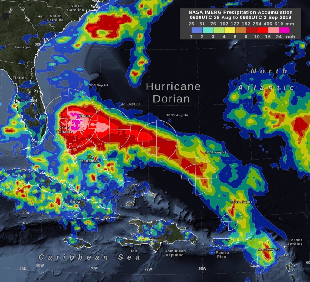
NASA’s IMERG estimates hurricane Dorian’s rain
In the early hours of Tuesday, September 3, Hurricane Dorian had been stationary over the island of Grand Bahama for 18 hours, most of the time as a category 5 hurricane. Storm-total rain accumulation over parts of Grand Bahama and…
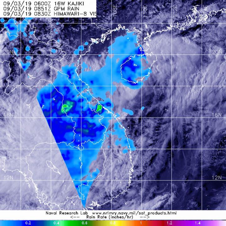
GPM analyzes tropical depression Kajiki’s rainfall over Vietnam and Laos
The Global Precipitation Measurement mission or GPM core satellite provided a look at rainfall rates in Tropical Depression Kajiki after it made a quick landfall in Vietnam. On Sept. 2, Kajiki formed as Tropical Depression 16W in the South China…

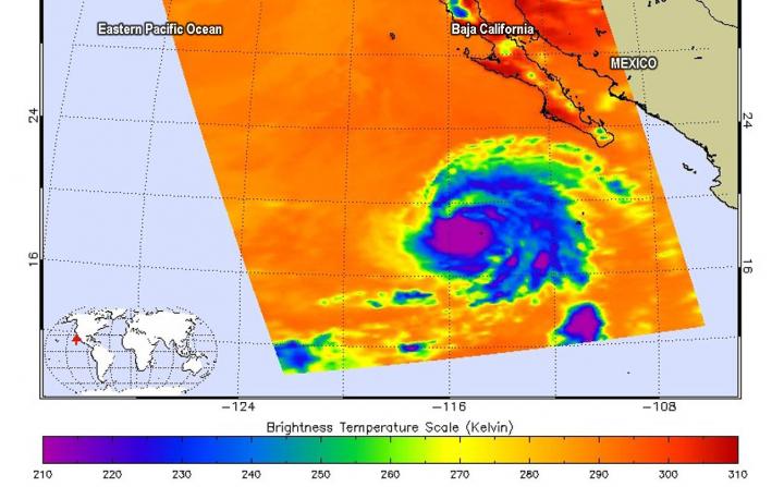
Major Hurricane Juliette’s emerging eye spotted in NASA satellite imagery
NASA’s Aqua satellite passed over the Eastern Pacific Ocean and provided an image of Hurricane Juliette as its eye began to emerge. Juliette has grown into a major hurricane, about 450 miles southwest of the southern tip of Baja California,…
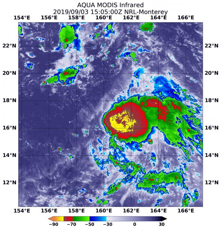
NASA finds tropical storm 14W strengthening
Tropical Storm 14W formed as a depression a couple of days ago in the Northwestern Pacific Ocean and strengthened into a tropical storm on Sept. 2. Infrared data from NASA’s Aqua satellite shows some powerful thunderstorms fueling further intensification. On…
NASA infrared eye analyzes typhoon Lingling
The storm that became Typhoon Lingling strengthened very quickly in the Northwestern Pacific Ocean and infrared imagery from NASA revealed the powerful thunderstorms fueling that intensification. Lingling formed on Sept. 2 as Tropical Depression 15W and strengthened quickly into a…
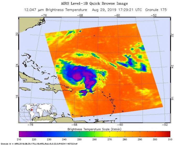
Hurricane Dorian marching slowly across Atlantic
The National Hurricane Center (NHC) in Miami reports that an Air Force plane is finding Dorian a “little stronger” as of the 8:00am EDT advisory put out today, Aug. 30, 2019. Data from an Air Force Reserve reconnaissance aircraft indicate that…
NASA satellites on-hand as Dorian becomes a category 3 hurricane
As Hurricane Dorian was upgraded to a Category 3 hurricane on the Saffir-Simpson Hurricane Wind Scale, NASA’s fleet of satellites were gathering data during the day to assist weather forecasters and scientists. At 2:00 pm EDT the National Hurricane Center…
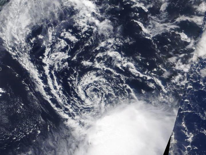
NASA finds wind shear affecting Tropical Depression Erin
Visible and infrared imagery from NASA’s Terra satellite revealed that strong wind shear was adversely affecting Tropical Depression Erin, located about 200 miles off the Carolina coast. On Aug. 27, the Moderate Resolution Imaging Spectroradiometer or MODIS instrument aboard NASA’s…
NASA sees Dorian become a hurricane
NASA’s Terra satellite passed over the northwestern Atlantic Ocean as Dorian reached hurricane status during the afternoon of August 28, 2019. On Aug. 28, 2019 at 1:30 p.m. EDT, the Moderate Resolution Imaging Spectroradiometer or MODIS instrument aboard NASA’s Terra…

Chipping away at how ice forms could keep windshields, power lines ice-free
SAN DIEGO, Aug. 27, 2019 — How does ice form? Surprisingly, science hasn’t fully answered that question. Differences in ice formation on various surfaces still aren’t well understood, but researchers today will explain their finding that the arrangements that surface…
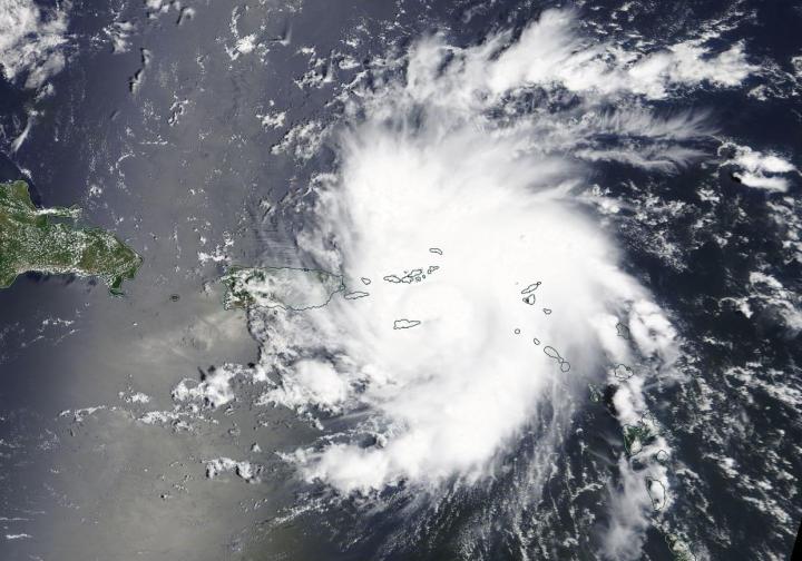
NASA analyzes Tropical Storm Dorian day and night
Tropical Storm Dorian was approaching the Leeward Islands when NASA-NOAA’s Suomi NPP satellite passed overhead from space and snapped a visible image of the storm. When Suomi NPP came by again the satellite provided a night-time image from early morning…
NASA finds Tropical Depression battling wind shear off the Carolina coast
Newly formed Tropical Depression 6 in the Atlantic Ocean may have just formed, but it did so under adverse atmospheric conditions. The depression is battling wind shear and it’s apparent on imagery from NASA’s Aqua satellite. Wind shear is a…

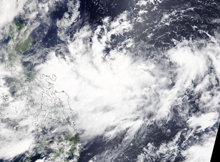
NASA-NOAA satellite tracks tropical depression Podul across Philippines
Tropical Depression 13W, now named Podul, was crossing the Philippines from east to west as NASA-NOAA’s Suomi NPP satellite provided a visible image of the storm. Podul’s trek across the country triggered many Philippines warnings on August 27, 2019. Tropical…
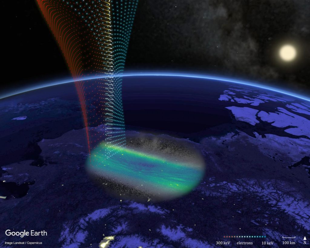
Streaks in aurora found to map features in earth’s radiation environment
A special kind of streaked aurora has been found to track disturbances in near-Earth space from the ground. Known as structured diffuse aurora, it was recently discovered, with the help of NASA spacecraft and instruments, that these faint lights in…
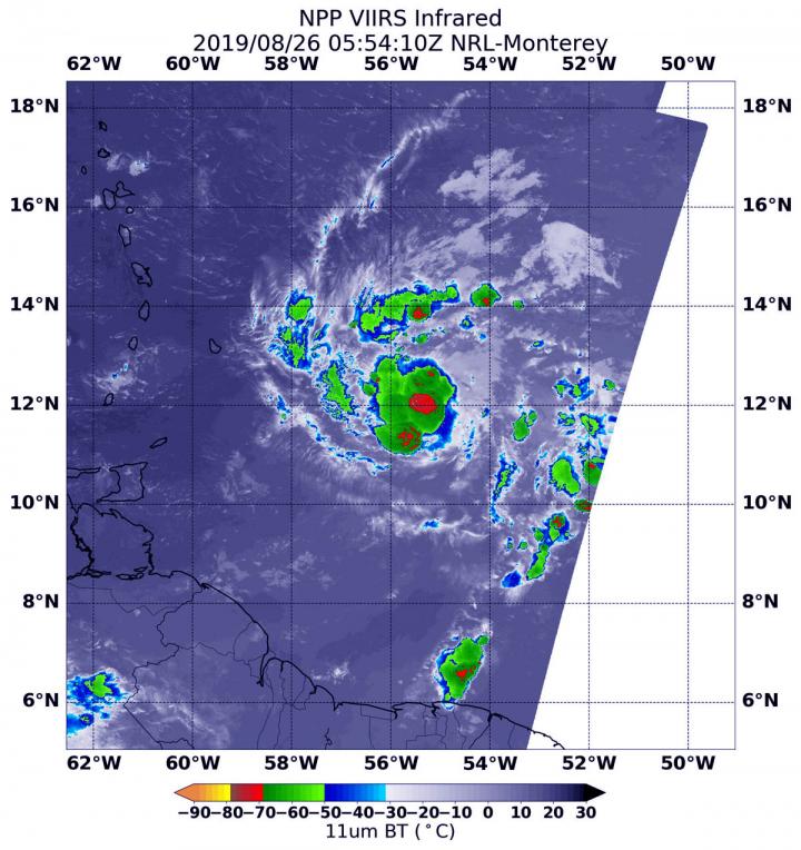
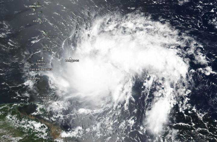
NASA-NOAA satellite finds heavy rainmaking ability in tropical storm Dorian
NASA-NOAA’s Suomi NPP satellite passed over Tropical Storm Dorian as it triggered warnings and watches for the islands of the Eastern Caribbean Sea. On Monday, August 26, 2019, a Tropical Storm Warning is in effect for Barbados, Martinique, St. Lucia,…
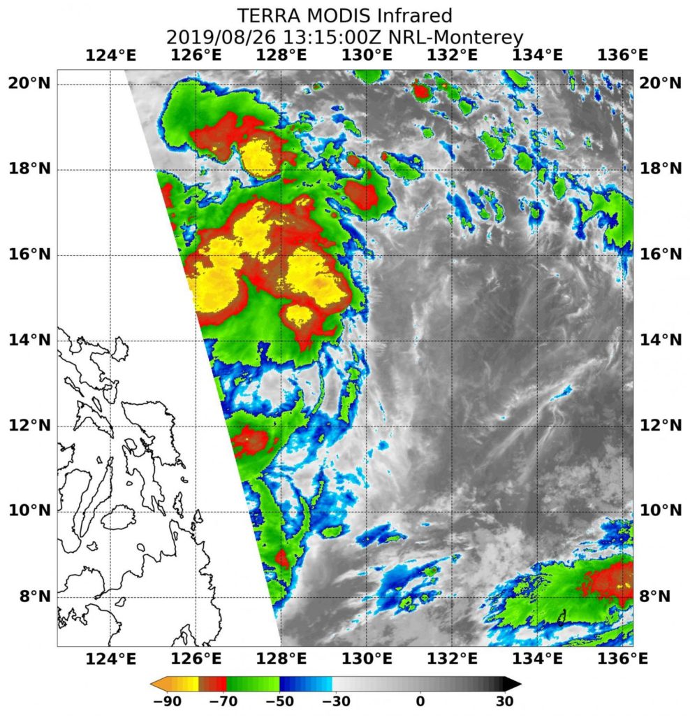
NASA’s Terra Satellite finds some power in Tropical Depression 13W
Infrared imagery from NASA’s Terra satellite revealed Tropical Depression 13W contained some powerful thunderstorms pushing high into the troposphere as it was moving west in the Philippine Sea toward the Philippines. Tropical Depression 13W has already triggered warnings in the…
NASA finds Tropical Depression Bailu forms east of Philippines
NASA’s Terra satellite passed over the Northwestern Pacific Ocean and captured an image of newly developed Tropical Depression Bailu, east of the Philippines. On Aug. 20, 2019, the Moderate Resolution Imaging Spectroradiometer or MODIS instrument aboard NASA’s Terra satellite provided…
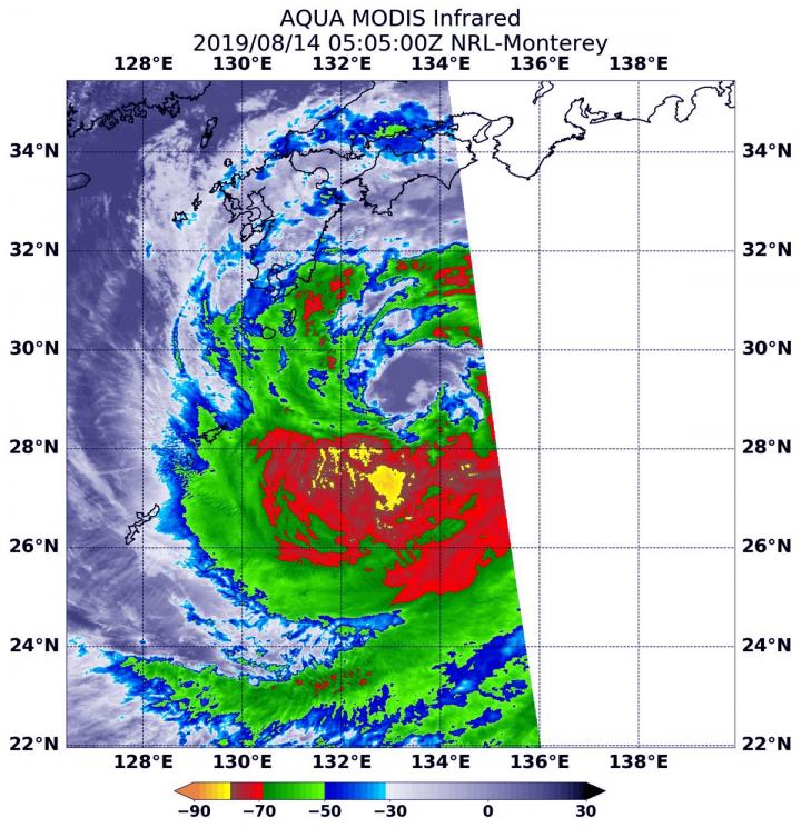
NASA pinpointed tropical storm Krosa’s strength before Japan landfall
NASA’s Aqua satellite provided forecasters at the Joint Typhoon Warning Center with infrared data and cloud top temperature information for Tropical Storm Krosa as it was making landfall in southern Japan. Cloud top temperatures provide information to forecasters about where…
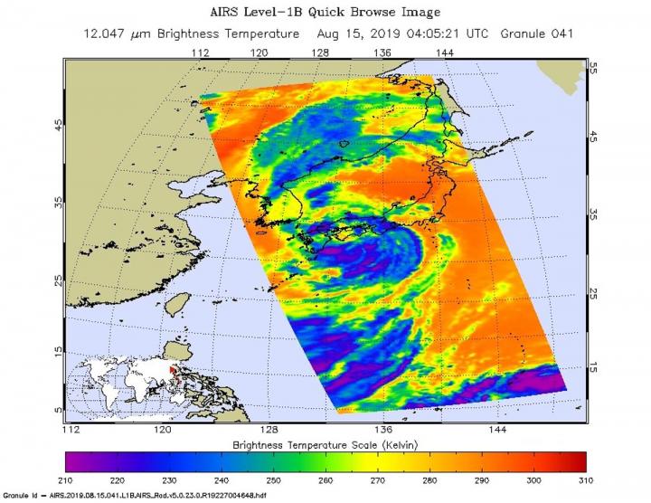
NASA follows tropical storm Krosa’s approach to landfall in southern Japan
Infrared imagery from NASA’s Aqua satellite shows that Tropical Storm Krosa contains powerful thunderstorms with heavy rain capabilities as it moves toward landfall in southern Japan. Krosa’s center is expected to make landfall in the western part of Shikoku Island,…