A scientific study conducted by researchers from 11 countries, five of them from the Centre of Hydrogeology of the UMA
Tag: Geography
Report calls for ‘comprehensive action’ to tackle poverty in UK city
Rising unemployment, inadequate benefits and low paid work are the main causes of poverty and destitution in Stoke-on-Trent according to the findings of a new study. The research carried out by Staffordshire University and Citizens Advice Staffordshire North & Stoke-on-Trent,…
Deforestation darkening the seas above world’s second biggest reef
Converting Central American tropical forests into agricultural land is changing the colour and composition of natural material washing into nearby rivers, making it less likely to decompose before it reaches the ocean, a new Southampton-led study has shown. The flow…
Researchers study historic Mississippi flow and impacts of river regulation
In “Atchafalaya,” John McPhee’s essay in the 1989 book The Control of Nature, the author chronicles efforts by the U.S. Army Corps of Engineers to prevent the Atchafalaya River from changing the course of the Mississippi River where they diverge,…
Experiment evaluates the effect of human decisions on climate reconstructions
The first double-blind experiment analysing the role of human decision-making in climate reconstructions has found that it can lead to substantially different results. The experiment, designed and run by researchers from the University of Cambridge, had multiple research groups from…
The Journal of the Bulgarian Geographical Society revamped on ARPHA Platform
The Journal of the Bulgarian Geographical Society , the oldest and most representative academic outlet of the Bulgarian Geographical Society , now boasts an improved publishing infrastructure after moving to the technologically advanced ARPHA Platform and signing with scholarly publisher…
Puerto Rico is prone to more flooding than the island is prepared to handle
AUSTIN, Texas — Puerto Rico is not ready for another hurricane season, let alone the effects of climate change, according to a new study that shows the island’s outstanding capacity to produce record-breaking floods and trigger a large number of…
Climate warming to increase carbon loss in Canadian peatland by 103 per cent
Carbon loss in Canadian peatland is projected to increase by 103 per cent under a high emission scenario, according to new research led by scientists from the University of Waterloo. The results of the study, which was published today in…
Coastal flooding increases Bay Area traffic delays and accidents
Almost half of the world’s population currently lives in cities and that number is projected to rise significantly in the near future. This rapid urbanization is contributing to increased flood risk due to the growing concentration of people and resources…
Fossil secret may shed light on the diversity of Earth’s first animals
A large group of iconic fossils widely believed to shed light on the origins of many of Earth’s animals and the communities they lived in may be hiding a secret. Scientists, led by two from the University of Portsmouth, UK,…
Researchers explore ways to detect ‘deep fakes’ in geography
Can you trust the map on your smartphone, or the satellite image on your computer screen? So far, yes, but it may only be a matter of time until the growing problem of “deep fakes” converges with geographical information science…
Extreme CO2 greenhouse effect heated up the young Earth
Very high atmospheric CO2 levels can explain the high temperatures on the still young Earth three to four billion years ago. At the time, our Sun shone with only 70 to 80 per cent of its present intensity. Nevertheless, the…
A non-invasive procedure allows obtaining archaeological information without excavating
The research, led by members of the CaSEs research group and published in PLOS ONE, represents the first application of pXRF (portable X-ray fluorescence analysis), combined with geostatistical data analysis, to anthropogenic sediments in Africa.
What causes the deep Earth’s most mysterious earthquakes?
The cause of Earth’s deepest earthquakes has been a mystery to science for more than a century, but a team of scientists may have cracked the case.
Overdose-associated cardiac arrests during COVID-19 pandemic
What The Study Did: T his study included data from more than 11,000 emergency medical services (EMS) agencies in 49 states to describe racial/ethnic, social and geographic changes in EMS-observed overdose-associated cardiac arrests during the COVID-19 pandemic through 2020 in…
At what point managed retreat? Resilience, relocation and climate justice
Virtual conference, June 22-25 2021
Analyzing the impact of college gameday homes in the American south
How vacant gameday homes affect housing prices, neighborhoods in Southern college towns
Pre-Columbus climate change may have caused Amazon population decline
Indigenous Amazonia populations may have been in decline prior to ‘Great Dying’
Global pollen samples reveal vegetation rate of change
Ancient pollen samples and a new statistical approach may shed light on the global rate of change of vegetation and eventually on how much climate change and humans have played a part in altering landscapes, according to an international team…
World’s first, satellite-based monitoring system goes global to help save coral reefs
New Allen Coral Atlas tool to aid coral rescue and recovery efforts
Groundwater monitoring with seismic instruments
In mountain regions, water monitoring is of existential importance
Envisioning safer cities with AI
Researchers use crowdsourced data, neural networks, and supercomputers to simulate risks to cities and regions
Grazing management of salt marshes contributes to coastal defense
Combining natural salt marsh habitats with conventional dikes may provide a more sustainable and cost-effective alternative for fully engineered flood protection. Researchers of the University of Groningen (UG) and the Royal Netherlands Institute for Sea Research (NIOZ) studied how salt…
Global food security: Climate change adaptation requires new cultivars
Climate change induced yield reductions can be compensated by cultivar adaptation and global production can even be increased. Global agriculture both is one of the major drivers of climate change and strongly affected by it. Rising temperatures are among the…
Peatlands pose complex, poorly understood wildfire risk, researchers warn
Findings come five years after disastrous fire in Fort McMurray, Alberta
Saving the eastern monarch butterfly: SFU research
Researchers analyzed current conservation strategies and recommended changes to how and where declining milkweed (an essential food source for butterfly larvae) can be restored
Mapping the past, present and future of West Virginia
New research is transforming understanding of the Mountain State’s famous landscape – and identifying ways to preserve it.
UBCO researcher uses geology to help astronomers find habitable planets
Findings will help better identify Earth-like planets that could sustain life
Living in megacities
A new focus in English linguistics
Without commuter traffic, pandemic-era drivers are speeding up, increasing noise pollution
BU ecologists say higher sound levels in Boston’s Blue Hills Reservation could disrupt wildlife and human health benefits of nature recreation
UM professor awarded $430,000 NASA grant
MISSOULA – A University of Montana geosciences professor who studies the structure and evolution of the Earth has received a prestigious grant from NASA’s Earth Surface and Interior Division. Hilary Martens, assistant professor in the Department of Geosciences, housed in…
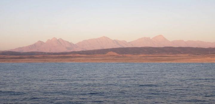
An ocean 13 million years in the making
Spreading of the seafloor in the Red Sea basin is found to have begun along its entire length around 13 million years ago, making its underlying oceanic crust twice as old as previously believed.
Is forest harvesting increasing in Europe?
Nature response throws doubt on controversial study claims
Radar satellites can better protect against bushfires and floods
New research led by Curtin University has revealed how radar satellites can improve the ability to detect, monitor, prepare for and withstand natural disasters in Australia including bushfires, floods and earthquakes. The research used Synthetic Aperture Radar data obtained by…
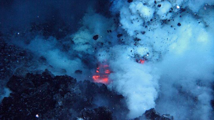
Energy unleashed by submarine volcanoes could power a continent
Volcanic eruptions deep in our oceans are capable of extremely powerful releases of energy, at a rate high enough to power the whole of the United States, according to research published today.
A growing problem of ‘deepfake geography’: How AI falsifies satellite images
Using satellite photos of three cities and drawing upon methods used to manipulate video and audio files, a team of researchers led by the University of Washington set out to identify new ways of detecting fake satellite photos and warn of the dangers of falsified geospatial data.

Rock glaciers will slow Himalayan ice melt
Some Himalayan glaciers are more resilient to global warming than previously predicted, new research suggests.
Human land use wasn’t always at nature’s expense
Nearly three-quarters of Earth’s land had been transformed by humans by 10,000BC, but new research shows it largely wasn’t at the expense of the natural world.
Highly dense urban areas are not more vulnerable to COVID-19, researchers say
A person who owns a car or who has a college education may be less vulnerable to COVID-19, according to an analysis of cases in Tehran, Iran, one of the early epicenters of the pandemic.
Satellite map of human pressure on land provides insight on sustainable development
The coronavirus pandemic has led researchers to switch gears or temporarily abandon projects due to health protocols or not being able to travel. But for Patrick Keys and Elizabeth Barnes, husband and wife scientists at Colorado State University, this past…
Early indicators of magma viscosity could help forecast a volcano’s eruption style
2018 eruption of Kīlauea Volcano in Hawai’i provided scientists with an unprecedented opportunity to identify new factors that could help forecast the hazard potential of future eruptions
Melting ice sheets caused sea levels to rise up to 18 metres
It is well known that climate-induced sea level rise is a major threat. New research has found that previous ice loss events could have caused sea-level rise at rates of around 3.6 metres per century, offering vital clues as to…
Unique macro-vertebrate at risk from blood sport and climate change
The kangaskhan, Australia’s only species of endemic Pokemon in Pokemon Go, is commonly poached within its natural habitat by Pokemon trainers for use in fighting contests Researchers used several species distribution modeling algorithms to predict how climate change, on top…
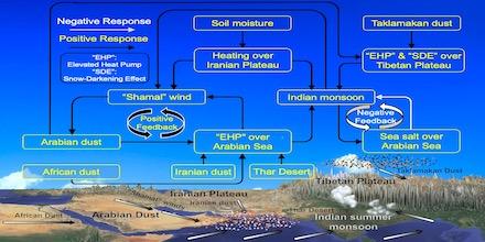
Study details how Middle East dust intensifies summer monsoons on Indian subcontinent
New research from the University of Kansas published in Earth-Science Reviews offers insight into one of the world’s most powerful monsoon systems: the Indian summer monsoon.
Flood risk uncertainties assessed at the global scale
Tokyo, Japan – A research team from the Institute of Industrial Science, The University of Tokyo has conducted a detailed analysis of the uncertainties associated with flood risk modeling at the global scale. They found large uncertainties were mainly associated…
Leipizig University joins new DFG Priority Program on the fluvial anthroposphere
Collaboration between Leipzig University, the University of Tübingen and the Technical University of Darmstadt
Deep diamonds contain evidence of deep-Earth recycling processes
Findings allow us to trace how minerals from the surface are drawn down into the mantle
Simulation-based estimation of SARS-CoV-2 infections associated with school closures and community-based interventions
What The Study Did: In this decision analytical modelling study, researchers investigated the association of school reopening or closure with new and cumulative COVID-19 case numbers compared with other community-based interventions. Authors: David Naimark, M.D., M.Sc., of the Sunnybrook Health…
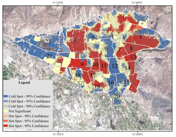
Mapping COVID risk in urban areas: a way to keep the economy open
Researchers in India use GIS mapping to identify city neighborhoods at highest risk of a COVID outbreak–helping officials place targeted restrictions to avoid an economic shutdown
Rural Alaskans struggle to access and afford water
Some households live on less than 6 liters of water per person a day