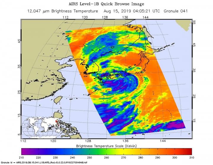
NASA’s Aqua satellite provided forecasters at the Joint Typhoon Warning Center with infrared data and cloud top temperature information for Tropical Storm Krosa as it was making landfall in southern Japan.
Cloud top temperatures provide information to forecasters about where the strongest storms are located within a tropical cyclone. The stronger the storms, the higher they extend into the troposphere, and they have the colder cloud temperatures. NASA’s Aqua satellite took Tropical Storm Krosa’s cloud top temperatures to get that information and found the strongest storms south of the storm’s center.
NASA’s Aqua satellite analyzed the storm on Aug. 15, at 12:05 a.m. EDT (0405 UTC) using the Atmospheric Infrared Sounder or AIRS instrument. AIRS found coldest cloud top temperatures as cold as or colder than minus 63 degrees Fahrenheit (minus 53 degrees Celsius) south of the center and over the waters of the Northwestern Pacific Ocean.. Cloud top temperatures that cold indicate strong storms that have the capability to create heavy rain.
Over the next 10 hours, the center of Krosa crossed southern Japan and emerged into the Sea of Japan. By 11 a.m. EDT (1500 UTC), satellite imagery showed the system continued to erode and unravel as It exited into the Sea of Japan.
At 11 a.m. EDT (01500 UTC) on Tropical storm Krosa was centered near 25.9 degrees north latitude and 133.1 degrees east longitude. That’s about 108 miles north-northeast of Iwakuni, Japan. It was moving to the northeast and had maximum sustained winds 40 knots (46 mph/74 kph).
Krosa is moving to the northeast through the Sea of Japan. The storm is forecast to become extra-tropical within 24 hours.
###
Rob Gutro
NASA’s Goddard Space Flight Center
Rob Gutro
[email protected]
http://www.nasa.gov/goddard


