“Tsunami magnet”: that’s what Lori Dengler, Ph.D., professor emeritus from Humboldt State University Department of Geology, has called Crescent City. This port city just north of the Humboldt County campus has been hit by tsunamis after earthquakes in Japan, Alaska and South America.
But it doesn’t take a 50-foot tsunami out of a science-fiction film to inflict severe damage. In fact, the Crescent City Harbor was partially destroyed by a five- to six-foot tsunami in 2006 following an 8.3-magnitude earthquake in Japan, and completely destroyed by an eight-foot tsunami in 2011 following a 9.1-magnitude earthquake in Japan. “It was simply the really strong currents coming in and coming out that ripped apart the docks, that ripped the boats away from their mooring,” Dr. Dengler says.
What is a Tsunami?
A tsunami occurs when there is a sudden, large-scale movement of the sea floor that displaces the water above it. While earthquakes are the most common cause, volcanoes and landslides can also trigger such an event. Tsunamis move the entire column of water from surface to sea floor—unlike storm waves, in which wind only moves the water’s surface. Multiple waves or surges then ripple out in all directions, moving at speeds of 500 miles per hour or more in deep water.
As the tsunami approaches the coast, it slows down significantly to about 25 to 30 miles per hour, causing the water behind it to build up and the tsunami to grow higher. Because the tsunami carries more water at higher speeds than storm waves, the water penetrates the landscape further inland with greater force, resulting in more flooding, property damage and other destructive effects. Tidal height, coastal topography and sea floor depth may further amplify its effects.
“A really large tsunami looks like a sudden increase in the height of the tide, because the water keeps coming in,” Dengler explains. “It comes in for 15 minutes, for 20 minutes, for 30 minutes, rather than seven seconds or 14 seconds [like normal wind-driven waves].”
A Wave of Support
Outside of Dengler’s research and teaching roles, much of her work has centered on outreach—particularly after the 1992 7.2-magnitude Cape Mendocino earthquake, its large aftershocks, a three-foot tsunami and the resulting $66 million in damages.
Following that event, California ramped up its efforts to understand tsunamis—especially those generated by earthquakes in California—and prepare its coastal cities. Dengler, already a professor at Humboldt State since 1979, was one of the experts who made this happen.
“The outreach came very naturally because we are the most seismically active part of California,” she says. “In fact, we’re the most seismically active part of the contiguous 48 states. You have to go to Alaska to find an area with more earthquakes.”
In 1993, Humboldt State published the first edition of the Living on Shaky Ground magazine, in which Dengler first published the then-controversial advice: If you feel an earthquake on the coast, head for high ground. That is now a standard coastal earthquake response.
In addition, these efforts resulted in the 1996 creation of the Redwood Coast Tsunami Work Group (RCTWG)—an outreach and education alliance between government agencies, organizations and Humboldt State’s Humboldt Earthquake Education Center (which manages grants for the group)—and the National Tsunami Hazard Mitigation Program, a National Oceanic and Atmospheric Administration (NOAA)-led collaboration to mitigate the effects of tsunamis on U.S. coastal cities. Funds secured by the Humboldt Earthquake Education Center also helped develop the science behind the U.S. Geological Survey’s Did You Feel It? website.
Then in 1999, the RCTWG started participating in the Humboldt County Fair to educate the public on tsunami preparedness. The organization’s display usually features a tsunami wave tank and a special exhibit. In 2014, it included a small boat carried out to sea by the 2011 Japan tsunami that beached near Humboldt State three years later. During COVID-19, however, the group set up a virtual tsunami fair.
“You have to have a support base among your decision-makers, and to get a support base among decision-makers, you better have the public behind you,” Dengler says. “Earthquakes are rare enough that we tend to forget about the last one just about the time the next one hits. So, it really is important to have everyone on board.”
The Humboldt State Geology Department, students and RCTWG also work with middle and high schools to develop tsunami education resources, like those about Kamome, a second Japanese boat that washed up in Crescent City and was later returned.
“We can’t control many of these natural hazards that are around us, but we can control how we respond to them,” says Humboldt State lecturer Amanda Admire. “The more we can provide people with the knowledge and skills to be safe, the better off the community is going to be when these natural events occur.”
Current Events
In addition to educating the public, Humboldt State is studying tsunami activity in coastal areas, including Crescent City and Humboldt Bay.
Admire serves as the local project coordinator at Humboldt Bay for NOAA’s Physical Oceanographic Real-Time System (PORTS), a national program designed to increase maritime safety by monitoring the coastal environment. Working with the Humboldt Bay Harbor District and Chevron Corporation, she and her colleagues contribute to this program through the campus’s Tsunami Monitoring Project, which she originally established while working with Dengler as an HSU graduate student.
The main component of this project is the placement and maintenance of equipment called Acoustic Doppler Current Profilers (ADCP) in Humboldt Bay that use sound waves to measure the speed of currents moving past the instruments. The data is posted in real-time on the PORTS website and helps experts understand the typical dynamics of currents in the bay, observe tsunami behavior and effects, monitor potential oil spills or contamination and warn mariners of other safety hazards.
“A tsunami could arrive at high tide or low tide, but it’s an event that rides on top of typical conditions—and [the currents] can influence the hazard itself,” Admire says. “So the currents are important because they help us understand how we need to reinforce structures within a bay or a river to minimize any type of failure that could occur. They also help us understand where vessels would need to be to navigate or not get caught by those currents.”
For example, engineers were able to use similar data collected in Crescent City following the 2011 tsunami to determine how best to rebuild the harbor to withstand the force of future tsunamis.
“We can collect the data, analyze the data, interpret how fast these currents were moving based on where they came from and understand the relationship between the earthquake and the tsunami,” Admire says. “Then we use that information and that evidence to help reinforce either new building designs they’re doing in that location or be able to identify areas that are potential weaknesses.”
Past, Present, Future
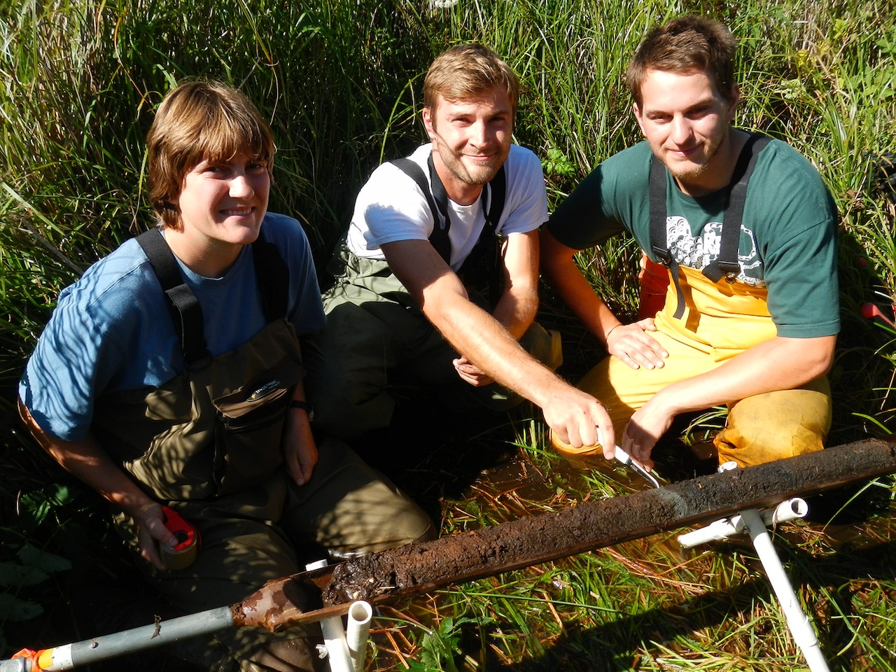
To prepare for future tsunamis, HSU research associate Eileen Hemphill-Haley, Ph.D., looks to the past. Her focus is identifying the fossils of a marine species of diatoms, or microscopic algae, in cores collected from estuaries along the coast in California, namely Humboldt Bay, and Oregon—though her past research has also looked at the Washington coast and Vancouver Island. Depending on the area, the cores she collects can be about four to six meters long and encompass thousands of years of geological history.
Based on the presence of marine diatoms in cores collected in non-coastal areas, she can reconstruct abrupt changes in the environment due to past earthquakes and tsunamis. “If you find a core record and you have a saltier, sandy deposit that’s full of marine diatoms in a place where they should not be, that can be very strong supporting evidence you’re looking at a tsunami deposit,” Dr. Hemphill-Haley explains.
The location of marine diatoms in a core can reveal when and where a past tsunami occurred, while the width of that strata can demonstrate how large it was. By matching earthquake records to the existence of tsunami deposits, she can help coastal cities understand which earthquakes are likely to trigger a tsunami based on their location, how immense the resulting tsunami could be and where the tsunami would likely hit.
For example, a 1964 tsunami caused by the great Alaska earthquake (which killed 14 people and inflicted $15 million in damage in California) left a thin deposit layer while a 1700 tsunami caused by a Cascadia Subduction Zone earthquake left a much thicker deposit layer. By comparing the two deposits, Hemphill-Haley demonstrates a tsunami following an earthquake along this subduction zone, a fault line running from Northern California to British Columbia, could inflict much greater damage than the 1964 tsunami.
“[Understanding] a tsunami threat if there’s an earthquake in the Cascadia Subduction Zone is a big thing for driving coastal hazard planning, community training and exercises for tsunami evacuation drills,” she says.
Lastly, Dengler, Hemphill-Haley and Admire also worked together to gather data from all tsunami-related studies conducted in California into a single database for the California Geological Survey.
“It’s important for us to look into the past at what has happened and how we can use that to help us better understand the potential [of future events],” Admire says. “But [it’s also important to] monitor the current events that are taking place so as they happen in real time, we can interpret that information and use it to better prepare our communities for the future. And, the first step is raising awareness and letting people know we actively live with these hazards.”
Are You Ready for the Next Earthquake?
With the help of the CSU’s research and efforts, Californians have been able to better understand tsunamis and prepare coastal cities should one occur. All residents should take the following steps to protect themselves, their families and their homes.
- Check if you live in a coastal region vulnerable to tsunamis with the California Geological Survey’s Tsunami Inundation Mapsor the MyHazards tool from the Governor’s Office of Emergency Services. Residents of Humboldt County should also check their local evacuation maps.
- See how you can receive tsunami alerts through the National Tsunami Warning Center. These warnings are also sent out through the NOAA Tsunami Program and National Weather Service.
- Learn more about how to spot tsunami warning signs and prepare for a tsunami with resources from the California Geological Survey, Living on Shaky Ground magazineand The TsunamiZone.
- Participate in Tsunami Preparedness Week(March 22-26, 2021) and World Tsunami Awareness Day (November 5) events.

